(Remember that you can click on the photos to see a
slideshow, and then hit "escape" to get back to the text. Also, a
note on the photo credits: as always, both Felice and I took these shots, and
many of my shots resulted from her suggestions.
I do the photo editing using Lightroom; my goal is to reproduce just
what we saw, as faithfully as possible.)
Usually, the forest roads between Kings Canyon and Sequoia
National Park are closed by snow in early November, but not this year. (This is a rather thin silver lining to the
drought.) So we took advantage of this
opportunity and found a really well-located boondocking site, north of Stony
Creek and south of Grant Grove.
Friday, November 11:
We took the Panther Gap/Mehrten Meadow hike out of Wolverton (8.4 miles,
1800 feet). Frankly, although the hike
itself was not difficult, the air quality was a disappointment. The forest service was conducting prescribed
burns in the Mineral King area, and the smoke was drifting over to the north
and east, obscuring the views. On our
way back, Felice scrambled up onto a boulder at Panther Gap:
Late that afternoon, just before sundown, we
stopped off at Lost Grove to pay our respects:
Saturday, November 12: It was another hazy day, so there was no sense in taking a "view hike.” Instead, we opted for Muir Grove (7 miles, 1200 feet). Since the road to the trailhead was closed, we started the hike where Cabin Creek crosses the Generals' Highway and then hiked down through a very recent prescribed burn (with a few still- smoldering logs!) to cross Dorst Creek. Usually, that stream crossing is difficult or impossible; but thanks to the drought, we had no trouble. The trail from Cabin Creek then intersected the main trail west of Dorst Campground.
Not surprisingly (given the difficult access), we were the
only ones in the grove. We first visited
the massive tree that Felice calls the "Sentinel," which guards the
entrance to the grove. Using our
outstretched arms, we measured the circumference to be in excess of 80 feet:
A hundred yards south of the Sentinel, there is a seldom-visited circle of very tall (over 200 feet) Sequoias, tightly bunched together:
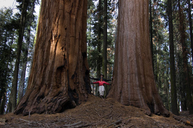
We then headed off cross-country, about a half-mile to the northwest, to see Felice’s favorite trees, the "Husband and Wife" pair. (Why isn't it ever "Wife and Husband?") Along the way, we came across this burnt out shell of a Sequoia, which is somehow still living -- this shot was taken from inside the tree, looking straight up:
Sunday, November 13:
It was a crisp, cool, clear day, so we decided to tackle Mitchell Peak (7
miles, 1800 feet). It took us almost an
hour to drive to the trailhead through the Big Meadows area. The dirt access road was undergoing repair,
and it was very slow going. But there
was no one else at the trailhead, and we didn't see anyone else the entire day!
We were pleasantly surprised at our ability to handle this
difficult trail – evidently, we were still benefiting from our conditioning
after hiking almost every day during our September trip. Beyond the sheer elevation gain and the
altitude, there were a few icy patches, and then we had to scramble (slowly and
carefully) over a boulder field as we approached the summit. Incredibly, it was warm, sunny, and calm at
10,000 feet in mid-November; the other times that we have taken this hike
(during the summer!), the summit has been very windy and cold.
This is a view east from the peak toward the Great Western
Divide; during late September, on our hike to Kearsarge Pass, we were looking
at that range from the other side:
Far to the north, beyond the Kaiser Wilderness, we could see some very high snowy peaks -- we took a bearing (330 degrees), and I am pretty sure this was the high country of central Yosemite, almost 100 miles away. This is a short video showing the whole panorama from the summit:
While we were relaxing in the sun and eating lunch, an eagle
was performing lazy spirals high above us -- because of the altitude, the sky overhead was a very dark blue, almost indigo:
That evening, we drove out onto a granite slab in the Big Meadows Area to await the rising of the "super-moon:"
Monday, November 14: We decided to hike up from our campsite to Big Baldy Ridge (1100 feet, 5 miles). Along the way, we came pretty close to the radio tower, which is visible throughout much of the area between Buck Rock and Dorst Campground:
Although there was still smoke in the south due to the prescribed burning, the views to the north were fairly clear:
That afternoon, we took a picture of our campsite, which was on a long cul-de-sac off of a rough forest road:
This was a lovely and silent site, even though it was just a little over a mile from the highway. The only downside is that throughout the forest, many of the old-growth pine trees are dead or dying, from a combination of bark beetles and the drought. The forest is loaded with fuel, just awaiting a spark.


