Thursday, October 25, 2018

The Mountain West, Fall 2018: Part 6 (Sedona)

(Click on the photos to see a slideshow; hit "escape" to get back to the text.  As always, both Felice and I took these photos.  I edit them on Lightroom, trying to reproduce just what we saw.)

Oct. 5:  We had arrived at the campground in the dark; in the morning light, we could see that the campground had recently been flooded -- there was fresh wet sand on the roadways and some tangled brush in the drainage ditches.  The kiosk attendant told us that the hurricane (the one we successfully dodged!) had caused a flash flood a couple of days back; they had just gotten the debris cleared and had just reopened the campground.  The campground, by the way, was very pretty -- lots of trees.  Not what we expected in Arizona, but our eyes have been opened!

We had always wanted to see Sedona, since it is relatively close to home (less than 500 miles, which is pretty close as compared with most of the West).  We've also heard that there is some good boondocking not too far from town, and the low elevation (around 4500 feet) means that it would be warmer than the Sierra in the winter.

Just to sample the hiking, we took the popular Courthouse Trail, and we were pleasantly surprised -- the rock formations were beautiful, and the trail was not crowded once we got away from the parking area.  The sunlight kept changing all day, and so did the cliffs:


That formation (the Courthouse) is several hundred feet high -- for scale, we are standing on a ledge at the bottom of this photo:


The trail went all the way around the Courthouse:


This is the Cathedral formation, visible from the northwest part of the trail:


We came across a group of healthy-looking ocotillo, which were bright green after the recent rainstorm:


The well-worn boots insisted on this shot -- we were on top of the Baby Bell formation, an easy climb:


The eastern side of the Courthouse was particularly colorful:


After the hike, we stopped off at the Chapel of the Holy Cross, built right into the cliff -- this looks post-modern, and yet it was built in the 1950s.  It was designed by a female student of Frank Lloyd Wright:


Back in town, we got some ice cream, and I played the pentatonic xylophone next to the Visitors' Center -- a very beautiful tone, made of thick-gauge aluminum tubing and mounted on coated stainless cable, with spacers (felt? rubber?) to help sustain the notes.  They are made by an outfit called Freenotes Harmony Park:


Oct. 6:  We left for home, with a wonderful overnight stop in the Palm Springs area to see some family members.  Excellent pizza was consumed, at last -- I had been wanting pizza for a month.

The Mountain West, Fall 2018: Part 5 (Taos and Santa Fe)

(Click on the photos to see a slideshow; hit "escape" to get back to the text.  As always, both Felice and I took these photos.  I edit them on Lightroom, trying to reproduce just what we saw.)

Sept. 30:  There was a visitor center near the RV park in Taos, and they had Motor Vehicle Use Maps for the Carson National Forest -- score!  Although the maps showed that there was plenty of boondocking in the desert, there was very little in the higher (and cooler) elevations.  So we decided to check out the Forest Service campgrounds between Questa and Red River on Highway 38.

Before heading out of Taos, we stopped for lunch at El TaoseƱo.  (Ordinarily, we don't eat out and rarely mention the restaurants; but the food in New Mexico is so great that we just have to say something.)  We walked in at noon on a Sunday, and the place (a large room) was jammed with locals, almost all of whom seemingly knew each other.  There was a lot of loud greeting and hugging.  This was festive, but it was also promising -- if this is where the locals go, the food must be outstanding!  (And it was.)  Truly great salsas, both red and green.

We headed north to Questa and then east (roughly) on Highway 38, looking at the campgrounds.  There were several that were still open, but all of them were right on the highway.  The best of the bunch was June Bug, right on the Red River (which is really just a noisy creek at this point).

After getting the trailer set up (in a site right by the creek), we tossed a few extra rocks into the creek to enhance the noise (fun!), and then convened the snacking circle:


The stars that night were excellent; the only problem is that the south wall of the canyon cut off the brightest part of the Milky Way:


Oct. 1:  We took the Middle Fork Lake trail (about 5 miles round trip, with about 1300 feet of gain).  The forest road to the trailhead was pretty rough, but nothing like the mining roads in Colorado -- even an ordinary SUV could have handled the road with no trouble.  The trail itself was pleasant, switchbacking up through the forest.  There was a nice mix of conifers and aspen:


Frankly, after what we had seen in Colorado, we were underwhelmed by the lake itself -- pretty, but not spectacular.  On the drive back to the town of Red River, though, the mountainsides were in full color.  Believe it or not, Felice took this with her iPhone:


Oct. 2:  There were rain showers in the morning, with more predicted during the day.  We felt like we had sampled the Sangre de Cristo Mountains around Taos, so we hitched up and headed for Bandelier National Monument, near Santa Fe, an easy drive of less than three hours.  There are signs along the road from White Rock into Bandelier stating that access is solely by shuttle from White Rock, but that is not true if you are staying at Juniper Campground.  (Juniper is not good for big rigs but there is plenty of room for small trailers and truck campers.  The "C" loop has more shade than the other two.)

That evening, we drove to Santa Fe for dinner, a long drive, but worth it -- we ate at the Pantry.  Excellent!  Then we walked around the Plaza in a light rain.  On the trip back to the campground, it rained hard most of the way.  (This was our one brush with the eastern edge of the hurricane.)

Oct. 3:  We spent most of the day at Bandelier, wandering through the ruins.  "Touristing" is not our usual style, but this day involved a fair amount of hiking and ladder-climbing, so we got more than the recommended daily minimum of exercise: 


Some of the cliff dwellings had been carved out of the canyon walls, which were relatively soft "welded tuff," hot volcanic ash that formed porous rock.  The Anasazi used stone axes to chip away the rock, not easy to do when standing on a ladder.  (By the way, "Anasazi" might be a politically incorrect name for the ancient Pueblos -- it is a Navajo word meaning "enemy ancestors.")

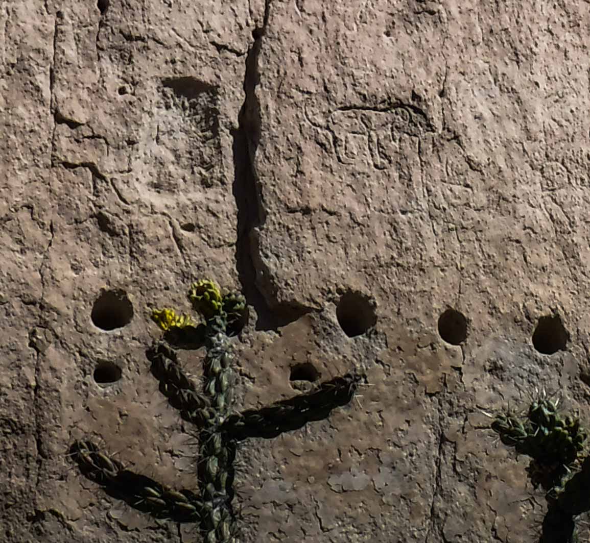
In addition to carving chambers into the cliff, the Anasazi built adobe houses adjacent to the cliff.  They would cut rows of round holes into the cliff face as a socket for the horizontal roof beams, as in the shot below.  You can also see a petroglyph of a dog (I think) in the upper right corner:


In the top center of this photo, to the left and slightly above the large chamber, there is a petroglyph of what looks like a Kachina doll:


It is somewhat amazing that the national monument allows the tourist to climb the ladders up into the ruins.  Although the ladders are well anchored into the rock and are very sturdy, they are steep, and the rungs are round.  We were wearing hiking boots, but some of the folks were in sandals -- yikes!  (Of course, the Anasazi must have worn sensible shoes when climbing the ladders carrying their children and their supplies.)

One particular area, the "Alcove House," involved several ladders, leading to a cave perched high above the canyon.  In this shot, Felice is standing next to a big kiva, a ceremonial chamber; on the right side of the photo, you can see the edge of the cliff and the canyon floor far below her:


For purposes of scale, this is a shot of the Alcove House from below -- just to the left of the center of the photo, you can see two people on one of the ladders:


We were pleasantly surprised that Felice's vertigo did not bother her at all, despite the heights and the sheer cliffs!

Perhaps it depended on the season, but sometimes the Anasazi came down from the cliffs and lived in ground-level dwellings -- this shows the foundation of a creekside village, laid out in an arc around a central plaza.  For scale, see the people at the bottom right:


After several hours of viewing the ruins, we hopped into the truck and headed over to Valles Caldera National Preserve, about a half hour away. Valles is (surprise!) a volcanic caldera; over a million years ago, a huge mountain blew up, an event 300 times larger than Mt. St. Helens, leaving a wide plain in the middle of the mountains. 

We hiked around Cerro La Jara, a 300 foot lava dome that rose in the middle of the caldera after the eruption.  To get a sense of the scale of this valley, you can just see the cluster of park buildings to the right of the base of the dome.  Incredibly, this is another iPhone shot:


The hike was short and pleasant; we could hear several bull elk bugling in the forest nearby, sounding like a concert for rusty gates.  We were glad that we had visited Valles, but we were also glad that we had not planned a whole day around it.  There were relatively few hikes available, and the park service restricts access to the interior of the park; only 35 vehicles are allowed into the backcountry each day.

Back at Bandelier, we found a great observation area, just inside the park boundary, where we could watch the sunset.  Felice took this shot of the Taos area (to our north) with her iPhone:


There was a big thunderstorm to the southwest -- at the bottom left of this next shot, you can see rain backlit by the sunset, with the bands of rain slanting in several directions due to the downdrafts bursting out of the base of the anvil cloud:


Oct. 4:  We hitched up and headed for Sedona, 450 miles away.  At sundown, we pulled into Cave Springs Campground, south of Flagstaff and north of Sedona.

Tuesday, October 23, 2018

The Mountain West, Fall 2018: Part 4 (Silverton)

(Click on the photos to see a slideshow; hit "escape" to get back to the text.  As always, both Felice and I took these photos.  I edit them on Lightroom, trying to reproduce just what we saw.)

Sept. 25:  We drove to Silverton from Montrose over Highway 550, the infamous "Million Dollar Highway."  Some folks have complained that this road is too steep, narrow and twisty, with too few guardrails.  We thought it was a piece of cake, compared to some of the other mountain roads we've been on.  Just take it slowly, and use the pullouts if you are holding up traffic.  Your passenger will enjoy the views.  The driver probably should watch the road.

Just north of Silverton, we turned off the highway into the South Mineral Creek area, at around 10,000 feet.  It's no secret that there is plenty of boondocking available there.  It is fairly close to Silverton, and there are not a lot of other places nearby that are open to boondocking; so we were not surprised to see a fair number of rigs in the wide-open flats next to the creek.  Great sites, but no privacy, and too many big rigs with generators.  (Bigger rigs often need more electricity, so they tend to run their generators more frequently and for longer periods of time.  That's not always true, but often it is.)

We were hoping to score a more secluded site up on the hill, overlooking the canyon and somewhat removed from the forest road.  Success!  The site I had spotted on Google Earth was open.  We hopped out of the truck and checked out the "driveway."  It was pretty steep, but not as steep or muddy as the one in Crested Butte.  There were some big boulders on either side of the driveway -- we had to do a fairly tricky S-turn to get around them.

The real fun, though, was in turning the trailer around in the campsite at the top of the "driveway."  The site was cramped, bouldery, and very uneven -- we were grateful to have such a small and maneuverable trailer.  You've heard of a three-point turn?  This was a long, slow, nine-point turn, carefully gaining a few degrees of rotation with each back-and-forth iteration.  It sounds like a hassle, but no -- it was a really enjoyable process, with Felice planning out the moves, one by one, and guiding the truck and the trailer through the obstacles.  This was her reward:


Every time we park the trailer in a new boondocking site, we try to aim the front window at the best possible view.  This was the result, viewed from Felice's seat at the dinette:


After getting the trailer leveled and stabilized and setting up the solar panel (pointed due south, with the help of the compass app on Felice's iPhone), we drove up the canyon to South Mineral Campground, which was fairly full of big rigs.  Although the campground is technically closed after Labor Day (no trash, no water, no bathrooms), dry camping is still allowed for self-contained vehicles until the snow flies and the road closes.  (For some reason, folks in the Rockies don't say "it's open till the first snowfall."  They say "it's open till the snow flies.")

Next to the campground was the trailhead for Ice Lake, our goal for the next day's hike.  The aspens were backlit by the late afternoon sun:


We took a quick drive (about 15 minutes) into Silverton, which was much more down-to-Earth than fashionable Crested Butte.  We got ice cream cones (a luxury!) and walked around town, gawking at the Old-West buildings.  This establishment was particularly unpretentious:


Since it was usually too chilly on this trip to sit outside in our camp chairs for cocktails and snacks, there are relatively few photos of our late afternoons.  That's sort of unfortunate, in a way -- the blog makes it seem like every day is consumed with strenuous activity.  But after hiking or setting up camp, almost every evening involves several hours of snacks, mixed drinks, hot showers, resting, reading, dinner, desert, star-gazing, and enjoying the peace and the silence.  Also, because we prefer to camp in cold places, we get to wear warm clothing and we sleep under several blankets, relatively rare treats for Southern Californians.  As we sometimes say, we're not roughing it -- we're smoothing it.

Sept. 26:  Early in the morning, the cliff on the mountain above the head of the canyon was sharply illuminated -- this view is from inside the trailer.  I think that those reddish strata are layers of volcanic ash, rather than ordinary sedimentary rock:


This was the perfect day (cool and breezy) for our big hike to nearby Upper Ice Lake, about 6 miles round trip with an elevation gain of about 2000 feet.  Instead of departing from the lower trailhead, we cheated -- we started the hike from a higher elevation, around 10,300 feet.  The guidebook told us that there was a rough four-wheel drive road that led to a shortcut.  The hardest part of the drive was parking -- the "parking lot" (a wide spot in a narrow road, just big enough for three vehicles) was a jumble of big boulders and deep muddy ruts.  No problem -- we crawled up onto the rocks in four-wheel low, and off we went.

The trail was steep and rocky the whole way; there were a couple of places where we had to actually use our hands to climb up and over rocky ridges.  This was not real "mountain climbing" -- it was just "manually assisted mountain walking."  Effortful but not life-threatening.  The thin air was a challenge, even though we were well acclimated to high altitude hiking.

Toward the top of the route, the trail passed over a crest, and this is what we saw:


I hope you are looking at that photo on a good monitor.  Believe it or not, that peacock color was far more astonishing and vivid in real life than anything that a computer screen can display, despite my best efforts at editing the image.  There were several other experienced hikers who arrived at the lake at the same time that we did, and everyone agreed that none of us had ever seen such a beautiful and jaw-dropping sight.  It's different from the deep indigo of Crater Lake -- more luminous, a lighter translucent neon blue, with electric aquamarine highlights and slanting late September afternoon sun sparkles.  Indescribable.  Mesmerizing.  Riveting.

Our hard-working "stout boots," the ones that dragged us up this tough trail to this amazing lake, deserve special recognition:


The color in this video is not too far off the mark:


We sat on the shore for about an hour, trying to soak it all in.  As we left, Felice surveyed the canyon of South Mineral Creek, surrounded by thirteen and fourteen thousand foot peaks:


At one point, we passed an outcropping of what I think is breccia, a volcanic formation.  But I am not sure -- it might just be conglomerate, since some of the inclusions were cobblestones, rather than angular debris.  Maybe it was a mix of both:


Back below treeline, the sun highlighted small groups of multicolored aspens among the dark evergreens:


Near the trailhead, Felice indulged her passion for waterfalls:


That evening, the sunset was framed by the canyon walls -- Felice gave it two thumbs up:


Sept. 27:  We hiked to Black Bear Pass, almost 13,000 feet.  The access to the trailhead was on yet another really tricky jeep road.  This time, Felice really did get out and walk, because the truck felt to her as though it was going to tip over and roll down the cliff.  (I did not share her misgivings, but the drive did require a lot of concentration.  Fun, in a technical way.)

The "trail" was actually the jeep road itself; the guidebook said that on weekends, there is a lot of traffic, but we saw only two jeeps all day long.  However, the trail surface was really difficult -- the gravel had been rounded by the jeeps into marble-size ball bearings, and the dried mud on the roadbed meant that the ball bearings were free to roll out from underfoot, which they certainly did.

The wind was howling up at the pass:


The west side of the pass looked down toward Telluride:


The east side looked out toward Silverton and the many "14ers" (14,000 foot peaks) near Lake City:


After eating our peanut butter sandwiches in the shelter of a rock outcropping, we headed down.  The descent was even trickier than the climb had been.  I walked as carefully as I could on the "ball bearing" gravel, but my feet slipped out from under me.  I didn't fall, but the sudden lurch felt like I had dislocated my hip -- a very sharp pain.  Felice was right there with the Advil -- yay for being prepared!  I limped all the way back to the truck, a couple of miles on that bad footing.  Not fun.

I was sure that our trip was at an end -- that we would have to begin the long drive home.  But miraculously, I felt pretty good the next morning, we went for another hike, and I was just fine.

Sept. 28:  This was a much better day -- we took the Minnie Gulch hike up to the Continental Divide Trail.  The route to the trailhead was another in a series of fun jeep trails, with more crawling over rocks on the edge of a cliff.  It could not have been too bad, though, since Felice never once got out and walked.  The trailhead was at 11,500 feet!

We were not surprised to be the only folks on the trail -- this was really out in the middle of nowhere.  (In the distance, we did see one intrepid young lady on a mountain bike.)  The trail angled upslope through a broad windswept glaciated valley.  At the ridgeline, we crossed the Continental Divide Trail, marked out with big stone cairns every quarter mile or so:


In this photo, I am standing on the divide, pointing to the Atlantic drainage:


After meeting up with the CDT, the trail followed the ridge to the north, steadily gaining elevation -- we went for about 6 miles round trip, ending up at around 13,000 feet.  The whole hike was far above treeline, so the geology was well-exposed; across the canyon, we could see a volcanic plug (the black cliffs and the talus slope), flanked by strata of volcanic ash (on the right side of the photo):


This was not the most photogenic hike we have taken, precisely because the landscape was so vast in scope; there is no way to provide any scale in the pictures.  And yet this was one of our favorite hikes of the whole trip -- such an isolated, wild, "top of the world" feeling.

To give some sense of scale, the truck is in the center of this shot:


There were mining ruins all along the trail and the jeep road, including this little cabin:


On our way back to our campsite, we stopped in Silverton for a minute to check the weather.  Surprise!  A Pacific hurricane was on its way to the Four Corners area (including Silverton), promising several days of heavy rain and flash flooding.  Uh-oh.  Our plan had been to head to Capitol Reef in Utah, directly in the central path of the storm.

Sitting in the parking lot near the Silverton Visitors' Center (great cell signal!), we read several of the detailed National Weather Service forecast discussions, each covering a specific geographical area.  They are full of technical language, but they provide the  most complete analysis.  Flagstaff looked bad.  So did Las Vegas.  And Grand Junction.  Even Reno was iffy.

But Albuquerque gave us hope -- they thought the storm would brush western New Mexico but not the central or eastern portions.  Only one problem -- we had no guidebooks for hiking in the Taos or Santa Fe areas, no downloaded Motor Vehicle Use Maps, only a partial "Four Corners" paper map.  We would have to wing it, depending on Felice's iPhone as our lifeboat.

This plan became our on-the-fly "draw play" strategy:  the storm would rush in from the southwest to the northeast, and we would run around the back of the storm and return home via the southern route, just after the storm had passed.  It worked!

Sept. 29:  We packed up, hitched up, and headed to Taos via Durango and Pagosa Springs.  Although it was only a 250 mile trip, it took most of the day, since the roads were slow and twisty.  Highway 64 was particularly beautiful, passing through large stands of aspen in the high country of the Carson National Forest.  We got a space in an RV park for the night and ate dinner on the patio at La Cueva (not fancy, but great food and excellent salsa roja).

Next:  Part 5 (Taos)


Saturday, October 20, 2018

The Mountain West, Fall 2018: Part 3 (Crested Butte)

(Click on the photos to see a slideshow; hit "escape" to get back to the text.  As always, both Felice and I took these photos.  I edit them on Lightroom, trying to reproduce just what we saw.)

Sept. 20:  We drove from Fruita through Montrose and Gunnison to Crested Butte, just over 160 miles, an easy drive.  Using Google Earth and the Forest Service Motor Vehicle Use Maps, I had spotted a bunch of decent boondocking sites in the canyons not too far north of Crested Butte.

This time, we did not unhitch the trailer -- Google Earth had shown me that there were a few wide turnaround areas in the canyon.  We cruised slowly up Washington Gulch, which was a relatively smooth gravel road (at least in the lower reaches of the valley).  We were surprised (and not pleasantly) to see so many RVs parked in the meadows on an early Thursday afternoon in mid-September.  Fortunately, the spot that I had hoped to get was in the upper part of the canyon, where the road was narrow and rough, not suitable for most RVs (except truck campers).  And yes, the spot was still open!

The muddy "driveway" up to our campsite was very steep -- probably the steepest unpaved grade I had ever towed on.  (Please excuse the preposition at the end of the sentence -- this is a very exciting story.)  I had to put the truck into "Four Wheel Low" (a rare event, prior to this trip) and crept up the hill.  The truck did not lose traction, but I had to give it a lot of gas to make any progress at all.  (End of exciting story -- I guess you had to be there.)

At the top of the access road, the campsite per se was very spacious (which, as we will see later, is not always a good thing):


There was no view of the canyon from the site because of all the doggone trees, but the trees themselves were pretty good:


Late that afternoon, a polite young guy pulled his car onto the lower portion of our "driveway" and told us that "about 20 of his friends and family members" would be joining him that weekend.  We were not happy to have neighbors, but it's a free country, so (to quote Tony Soprano), "Whaddaya gonna do?"

Sept. 21:  Just after breakfast, Felice went to get something out of the truck.  Something was coming out of the trees, just a few feet away from the trailer -- a fairly large bull moose!  She called to me and (showing great presence of mind) snapped a couple of photos with her iPhone:


After the excitement of the moose wore off, we finished our coffee:


This is not a trick shot -- that is a reflection in the window:


 We headed back into town to do a few errands but were waylaid by Gothic Mountain:


That afternoon, we had time for a short hike in the upper part of Washington Gulch.  The trailhead was at around 11,000 feet; we hiked for about four miles (round trip).  The road up to the trailhead was not too rough, but there was one hairpin curve that was too tight for a long wheelbase truck, so we had to do a three-point turn.  That was something I had never encountered.

From the trail, we could see into the Slate River canyon, otherwise known as the "Oh-Be-Joyful" area (great name!):


The trail leading from Washington Gulch over to the Gothic Valley looked down on the town of Crested Butte:


The geology of the Gothic Valley was complex -- the strata ran every which way:


Sept. 22:  We headed out toward Kebler Pass on Route 12, a surprisingly-busy gravel road, to Horse Ranch Park, and took the Gold Creek trail.  We hiked around 7 miles, round trip, with less than a thousand feet of elevation gain.

Not far from the trailhead, we came across an aspen grove under attack by some ambitious beavers.  At first, we could not figure out why they would cut down so many large aspens and then just abandon the trunks, wasting all of that effort:


But a close look at a nearby pond cleared up the mystery -- they cut down the trees so that they could get to the branches to build their lodges and their dams.  Note that the leaves on these branches are still fresh and green -- very recently cut!


All along the trail, there were good views through the trees -- this is East Beckwith Mountain, I think:


According to our guidebooks, the aspen groves in this area are some of the largest in North America:


The trail passed through the Raggeds Wilderness (not ragged):


I am pretty sure that the arched peak is Marcellina Mountain, on the left side of this photo.  Geology aficionados (and aren't we all?) will of course recognize it as a classic laccolith, where a blob of magma rose under the base of the mountain, caused the overlying strata to bow:


(Just to be clear, I did not know that until I looked it up.)

The aspens were so bright and so dense that the air looked like light green water.  We took a super slo-mo movie:


On our way back to our campsite, we came across my favorite road sign:


Back in town, we noticed a lot of activity.  It turns out that this was the local celebration of Vinotok, a pagan harvest holiday, complete with a bonfire and a parade.  Felice got so excited that the end of the video has the marchers going straight up:


It was too chilly to have cocktail time outside, but we could still see the late afternoon sun on the aspens:


That evening, we discovered that in addition to the promised "20 friends," a new group arrived, about 50 kids from town, with little tents dotted all around us.  Not too close, but still annoying.  They all went down to town to participate in the Vinotok festivities and then came back late at night.  Fortunately, they were not too noisy, and they were all gone by the middle of the next morning.  Most astonishingly, they did not leave one speck of trash --  a miracle!

Sept. 23:  We often have multiple guidebooks for any given area -- sometimes, one author will describe a hike that the others have omitted.  This was one of those instances -- one of the books mentioned a newly-opened trail to the North Pole Basin, which was not open to the public until around 2013.  It sounded good, and it was great.

We headed up through the Gothic area to the trailhead (just north of Schofield Pass).  The guidebook warned us that the access road from Schofield Pass to the North Pole trailhead would be tricky, and it was -- very narrow, very rough, cut into the side of a significant cliff.  Much more suitable for a little Jeep than a full-size truck. 

We crawled along very slowly and carefully.  Big bulging ridges of bedrock caused the truck to lean over sideways toward the edge of the cliff.  I was not alarmed, but I was fully alert (and having fun, in a cautious way).  At one particularly challenging place, Felice threatened to jump out and walk.  (She didn't, at least not this time.)  I asked her to take a video of the truck inching over the really interesting boulders, but she did not think that this would be a good idea. 

Fortunately, when we got to the trailhead, there was a small flat space available for parking.  We were the only vehicle at the trailhead (always a good sign!), although later in the day two more vehicles arrived.  (Most of the trail is on land belonging to the Rocky Mountain Biological Laboratory.)

The first part of the trail was pleasant but unremarkable, winding upward through the forest.  At one point, we came across an abandoned wooden hot tub, so I climbed in:


(It turns out that this hot tub belonged to a defunct resort, which is now part of the RMBL property.)

Eventually, the trail breaks out of the trees and begins a fairly steep climb up an old mining road.  As we climbed, the south side of the Maroon Bells came into view:


The upper portion of the trail was above treeline, with sweeping views of the surrounding peaks:


This shot provides an even better view of the Maroon Bells, in the center of the photo.  For most of the day, we were completely alone in this chilly and breezy basin, at nearly 13,000 feet:


Felice is looking up at the uptilted strata of Crystal Peak:


Usually, our pictures come reasonably close to capturing the feeling of the places we go.  These really don't -- there is no way to catch the huge, open, silent expanse of this wild area.  This was among our favorite hikes of the whole month-long trip.  (For the record, we hiked about 7 miles round trip, with about 1500 feet of vertical gain.)

Sept. 24:  After breakfast, it looked like it was going to rain; being hardy Californians, we just hitched up and fled, heading down to Montrose for some errands, and then on to Silverton.  As we left Washington Gulch, we stopped for one last view of Gothic Peak:


Next:  Part 4 (Silverton)