(Remember that you can click on the photos to see a slideshow, and then hit "escape" to get back to the text. Also, a note on the photo credits: as always, both Felice and I took these shots, and many of my shots resulted from her suggestions. I do the photo editing using Lightroom; my goal is to reproduce just what we saw, as faithfully as possible.)
(Please forgive the occasional text formatting glitches -- this is a known issue with Google Blogger, and it is not worth the time it takes to fix it!)
(Please forgive the occasional text formatting glitches -- this is a known issue with Google Blogger, and it is not worth the time it takes to fix it!)
We had time for a quick trip to see the Sierra in
deep snow, after an extraordinarily wet year.
The only hitch was that we had to have bombproof cell coverage, so that
I could answer student questions by email every evening (in preparation for
final exams). So we ended up at the
Highlanders RV Park in Bishop: not our usual boondocking trip, but it would
have to do. Anyway, almost all of the
roads into the high country were blocked by snow, leaving us little choice.
Tuesday, April 25: We headed up Highway 168 to Lake Sabrina,
fully expecting that we would never get that far. The county road department had told us that
the road would be plowed only as far as Aspendell, a couple of miles downhill
from the lake. And sure enough, as we
approached the edge of this little town, there was a sign saying "Road
Closed Ahead 500 feet." Bad news.
I started to pull over and park. But Felice said, "Sometimes those signs
are wrong. Let's go check it
out." And sure enough, the gate was
wide open and the road was plowed to within a quarter-mile of the lake: score
one for she who questions authority!
We strapped our snowshoes to my backpack and trudged up the
hill. The trailhead on the east end of
the dam was in deep snow. We tried
hiking without the snowshoes but it was impossible: the snow was too deep into
soft. So we put on the snowshoes and
tried to find the trail.
After about a half hour of hunting around, aided by my GPS
and by Felice’s iHikeGPS iPhone app, we got exactly nowhere. The cliffside was so steep, and the trail
itself was so thickly buried in snow, that it would have been too dangerous to
cross the steep snowfields where the trail was supposed to be.
As a more-than-adequate consolation prize, the lake basin was really beautiful
– we had never seen it in such deep snow:
Heading back to the car, we crossed Bishop Creek and realize
that we had taken pictures here during the fall color season. This is what it looked like on September 30, 2008:
We then decided to try our luck at South Lake but soon ran into a locked gate several miles below the lake. So we set up our chairs on a bridge over the
stream and enjoyed our peanut butter sandwiches. When all else fails, eat lunch.
Finally, we headed back to the North Lake turnoff, not far down the hill from Lake Sabrina. The road to North
Lake rises out of the Sabrina Basin, giving us sweeping views of the range of
peaks behind the lake. All of these,
including Mount Darwin and Mount Wallace, are well over 13,000 feet. In this picture, Felice is the tiny figure in the bottom
center of the shot, silhouetted against a snowfield:
We kept going for a while but were eventually forced to turn back when the drifts got even steeper, accompanied by a sharp cliff on the downhill side. Too risky -- one misstep would have ruined our whole day.
Wednesday, April 26:
It was a dark and stormy morning.
We had hoped to hike to Minaret Vista, west of Mammoth Mountain, but it
was obvious that there would be no view from the top due to the thick cloud
cover. This is the view of Mammoth Crest
and Crystal Crag, looking west from the Twin Lakes area – not a good day for high-altitude
hiking. Crystal Crag is the dark obelisk just to the left of center:
And this is Crystal Crag and Mammoth Crest as seen from the north, on the trail to the crest out of Lake George, in July of 2009. Crystal Crag is the big fin in the center of the shot:
So instead of hiking into that storm, we headed into the Lakes Basin and started our walk from the Tamarack Lodge. Inside the lodge, the windows were completely covered with deep snowdrifts:
Fortunately, the resort had just stopped grooming the network of cross-country ski trails, so that we were free to snowshoe wherever we
wanted. The surface was somewhat packed
by all of the grooming equipment, and we were able to make much of the hike
without snowshoes.
It was both gratifying and amazing to see so much heavy snow
cover extending over so many square miles of territory, storing up so much
precious water. This was not fluffy snow -- according to the remote sensors, many locations are holding 50 inches of water equivalent (and often more), just waiting for the big thaw:
As we reached Lake Mary, it started to rain slush: not
exactly snowing, not exactly rain. (The
English language needs a new verb:
"slushing."
"Sleeting” is not quite accurate.)
Felice posed on the edge of the frozen lake.
We quickly headed back downhill using the Lakes Basin
Trail, which was not packed but was perfect for snowshoes. We hopped in the truck and headed south to
Convict Lake; as we had hoped, the trail on the north side of the lake (i.e.,
the side exposed to sunshine) was fully melted out. The storm was just starting
to clear up. That's Laurel Mountain at
almost 12,000 feet on the right side of the shot. Mixed in with the granitic rock is a healthy
dose of metamorphic "roof pendant," on the left side of the ridge. Felice is in the lower right corner of the shot:
As the storm cleared, the wind began to howl; I think that
some gusts approached 50 miles an hour, using the ancient Beaufort scale to estimate the wind speed.
Even though the lake is tiny, fairly big waves soon developed (about 3
feet high), and the wind was blowing the spray from the whitecaps in clouds
across the lake:
This shot was taken a little later from the spillway at the
east end of the lake. It was blowing so much spray that I had to use our little waterproof camera to take this shot. That's Mount
Morrison off to the left, over 12,000 feet high:
As we were driving back to Bishop, we passed the vista point overlooking the whole Bishop Creek drainage, one of my favorite views. Usually, it's too tricky to stop here because we are towing the trailer, and I don't get to look at this wonderful view because I am watching the road. But since we were driving the truck with no trailer, I finally got a chance to pull over and look at this whole area in heavy snow cover. Lenticular clouds were developing in the lee of the mountains:
This is a zoomed-in shot of Mount Tom (about 13,600 feet) and the Bishop Creek basin, with Buttermilk Country and the Tungsten Hills in the left middle foreground:
Thursday, April 27:
The weather had cleared, so this was our day for Minaret Vista. The trail started at the Mammoth Mountain
Inn, at the base of the ski resort. We
were relieved to find that the trail to Minaret Summit was well-packed; we
later discovered that the resort had been offering catered snow cat tours over
this route, conveniently compacting the snow for us. (We still needed our snowshoes, but the going
was much easier than it would have been in fluffy snow.) These tours apparently cost $60 for each
person, and the website describes the experience:
After a day on the slopes,
celebrate a spectacular view over the Ritter Range and the Minarets with a
toast at one of Mammoth’s most scenic spots. After the tour, enjoy chocolate
covered strawberries, a charcuterie board, and a glass of wine with the sun
setting over the Sierra peaks.
Later in the
day, we saw one of the snow cats parked down by the Inn, and it looked really
luxurious and futuristic, with upholstered armchairs in a glassed-in
climate-controlled cabin. I prefer our method of getting to the summit (no people, no machinery), but those charcuteries sure sounded good. (I had to look it up -- little meat snacks.) We also discovered that the tours were on Fridays and weekends, so we were glad to have missed that whole mechanized event.
We couldn't
resist a "snowshoe shot." We were a little concerned that our new red windbreakers would clash because they are slightly different shades -- (you know how important fashion is to us) -- but you be the judge:
This is a
panorama of the entire ridge:
For the sake of comparison, we were here in late September of 2016, at the end of five years of drought:
On our way
back down to the Inn, a wet cumulus cloud passed overhead, right near the
sun. We could see some rainbow
highlights at the edges of the cloud , but the camera was able to pick up the colors better than we could:
Friday, April 28: We hiked into the McGee Creek area. In the summer, this hike is hot and exposed, but we were blessed with a cool, breezy day. The road to the campground had not been plowed, but most of it had just melted out. There was a 10 foot thick wall of icy snow blocking the road to the trailhead. No problem: we parked the truck and kicked steps into the side of the snowdrift. Beyond the blockage, the road was clear to the trailhead:
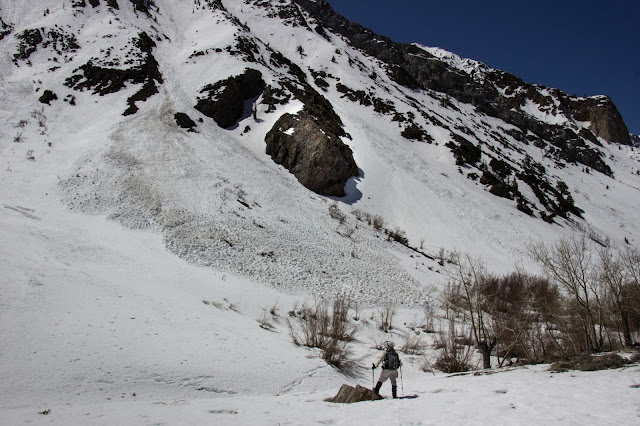
Apparently, there had been recent avalanche activity in this canyon; we stayed well away from the avalanche chutes:
We quickly realized that we had our
own personal Sierra creek basin -- we didn't see anybody else all day long:
Although the snow was fairly soft, we couldn't really use our snowshoes because there was so much brush (mostly willow) across the trail. So I carried the snowshoes on the back of my pack in case we really needed them, and we trudged several miles through soft snow on slanting hillsides. It was fun but exhausting:
(Note to self -- it's not a good idea to carry the snowshoes like that for any length of time, especially not when hiking 6 miles through soft, deep snow with a lot of underbrush. Two days after this hike, I came down with my first (and hopefully last) case of sciatica, almost certainly caused by the awkward weight of the snowshoes, coupled with the bad footing.)
From the floor of the canyon, we could see that the mountain
ridges far above us were covered in dangerous ice cornices. This picture of the crest running from Mount
Crocker on the left toward Mount Baldwin on the right (outside the shot), all over 12,000 feet, shows
the overhanging layers of ice, just waiting for an excuse to come crashing down the
mountainside. I'm guessing that these massive ice formations are about 80 to 100 feet thick:
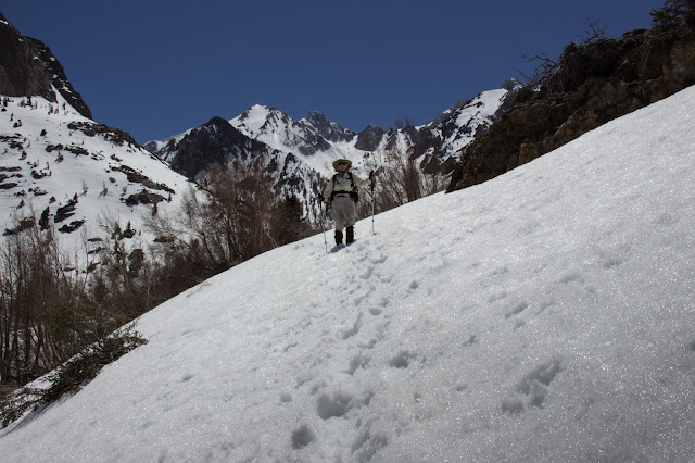
Some of the drifts over the trail were a little daunting, but we kicked steps into the snow in order to cross safely over the steep places:
Some of the drifts over the trail were a little daunting, but we kicked steps into the snow in order to cross safely over the steep places:
We were delighted to spend a perfect day in our own private glacial canyon:


