Sunday, May 20, 2007

Sequoia National Park, May 2007

We took a quick trip up to Sequoia. Most of the trails were pretty snowy. On our long hike to Heart Lake above Lodgepole, we didn't have snowshoes and had to "post hole" through deep soft wet snow (in other words, our boots punctured the crust and our footprints looked like post holes). But our first view of the lake made it all worthwhile:


There was no one else for miles around, and the lake was still partially frozen:


On our drive back to the Montecito resort, we passed a couple of early-season bears tearing up a log, looking for grubs:


We took a short hike to Lost Grove. Click on the picture and look carefully at the ground between the bases of the trees:

Tuesday, May 01, 2007

Mendocino and Santa Ynez, April 2007

During Spring Break of 2007, we stopped off to do some bike riding in the Santa Ynez Valley. The poppies were going strong:


This is Felice's favorite oak tree on Happy Canyon Road:


We camped for several days near Fort Bragg. This is a trillium:


The rides in Russian Gulch and Van Damme State Park were mostly along the streams:


The rhododendrons were growing amongst the redwoods:


Saturday, January 06, 2007

Yosemite, January 2007


Felice and I spent the first several days of 2007 in Yosemite, hiking and snowshoeing. The first view of the valley after Wawona Tunnel is always exciting. [Remember to click on the pictures to see them full size.]


One evening, we hiked up the south wall of the valley and watched Half Dome turn orange in the sunset.


In honor of Ansel Adams, I turned a couple of the pictures into black and whites. Here is the full moon rising over Half Dome.


These snowy boulders were reflected in the Merced River.


This herringbone pattern was made by a few slanting logs reflected in the river.


We snowshoed up to a fire lookout tower near Crane Flat. Apparently, a mountain lion got there before we did.


The day before we left, it snowed several inches. The next morning, we took a hike near our cabin. The trees and bushes were all coated with snow and ice.

Monday, July 31, 2006

Northern Calif & Oregon Cascades, July 2006

Felice and I spent much of July in the redwoods of Northern California and in the Cascade Mountains of Oregon. We stayed for three weeks in our tiny trailer, and it was (amazingly) very comfortable and a lot of fun. A day by day description of the trip would be very repetitive -- lots of hiking and biking along beautiful streams, through the trees, in the mountains. [Remember to click on the pictures to see a bigger version -- the pictures look a little better blown up.]

We started out in Northern California. Although the coastal redwoods are not as massive as the Sierra Sequoias on an individual basis, they are much more numerous, and they grow in lush surroundings. They tend to cluster in family groupings -- this is on the James Irvine trail in Prairie Creek:


This is the same shot, edited much later in Lightroom:


Some of the state parks (and national forests) permit mountain biking on selected trails through the redwoods and along the rivers. These are "singletrack" trails, which tend to be challenging -- full of roots and rocks. But it was a pleasure to be able to ride through the deep forest on narrow paths cushioned with bark chips and leaves:


We spent a lot of time taking pictures of wildflowers. (In fact, we have about 800 pictures; be glad we aren't posting more than just a fraction of them.) Here is a small sample:


Columbia Lily


Lupine


Some tall pink flower - fireweed, I think.

On our honeymoon in 1978, we spent some time at Clear Lake, east of Eugene, Oregon, and we were happy to discover that the lake is still as blue as it was back then:


Clear Lake

After riding and hiking in central Oregon, we went north to the Columbia Gorge. There are probably 20 or more major waterfalls in the Gorge, and we hiked to virtually all of them. Again, it would be redundant to post pictures of all of them; here is a representative sample:


This is the same shot, edited much later in Lightroom, which enabled me to correct the white balance:


I could not resist including more waterfall shots -- the falls are everywhere throughout the Gorge, and Felice just could not get enough of them, especially because the weather was hot and the falls cooled the air:


We hiked to Tunnel Falls on a hot day (a 14 mile hike!). There is a tunnel immediately behind the thundering waterfall:


This is the same shot, edited much later in Lightroom:


There were other falls with trails behind the water -- Felice is right in the middle of the shot, between the two halves of the falls:


We next stayed at Mt. Hood, an 11,000 foot volcano not too far south of the Gorge:


Mt. Hood and Bear Grass

The wildflowers (mostly lupine and Indian paintbrush) were just getting started on the mountain, since the snow had recently melted:


Lupine on Mt. Hood

Friday, June 09, 2006

Santa Cruz Redwoods, June 2006

in June of 2006, we spent several pleasant days hiking and biking in the redwoods near Santa Cruz. We stayed in our little trailer, in a quiet RV park across the river from Henry Cowell Redwoods State Park.


This is typical of the mountain biking that we did each day. There are several former railroad grades or logging roads that wind through the forest for many miles, generally contouring along the hillsides and across small creeks.


Many of the smaller redwood trees were showing a lot of new growth (the lighter green vegetation) after a season of heavy rain.


Because of all the rain, little "Tiptoe Falls" was flowing pretty well. I took this time exposure (at about a 15th of a second), using a handy stick as an improvised monopod.


It was a good season for wildflowers. This is a wild iris.


We aren't sure what this is. Goldenrod, perhaps?

Thursday, April 27, 2006

Southwestern Utah, April 2006


Here are a few shots of our trip. The formatting of the blog is very poor -- but you get the idea. If you want to see a particular picture in more detail, just click on it. When you want to get back to the blog, just hit the "back" button. [This is probably obvious to most folks, but it was news to me.] Each caption refers to the picture below.

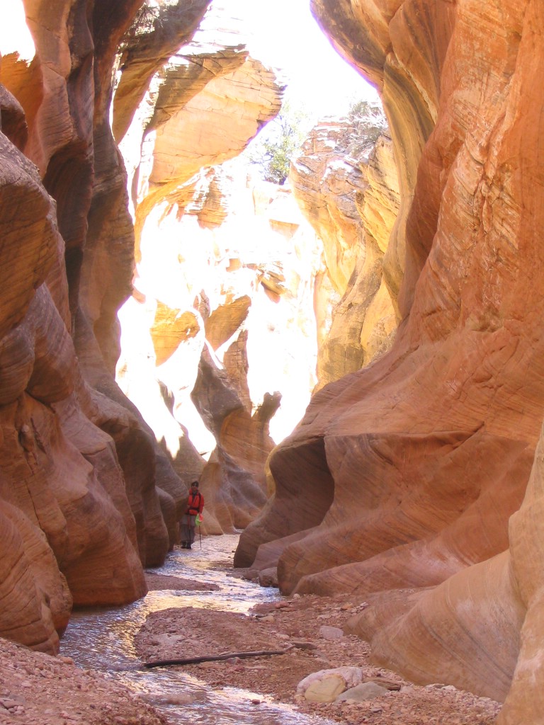
The plateaus of Utah are cut by streams that sometimes form "slot canyons," some of which are so narrow that you can't see the sky. We did not go into any of those, but we did see a couple of really narrow canyons. You can see Felice in the orange jacket in the shot below -- we had to hike through the stream.


This is almost the same shot, edited years later in Lightroom:


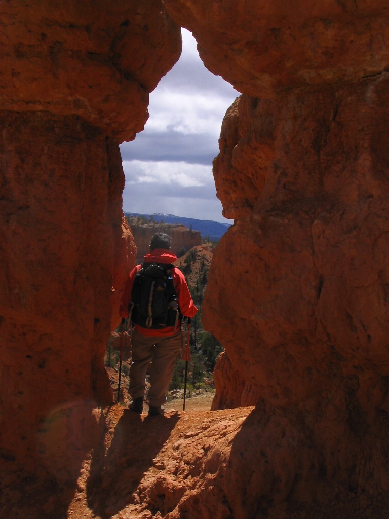
The canyon walls and rock formations were eroded by wind and by "frost wedging," where the snow melts and freezes, breaking the softer rocks apart and leaving the harder rocks as caps. The archway below was formed by wedging. In the distance beyond Felice, a snowstorm is approaching us.


Biking in Red Canyon on a cold and windy day. Great paved bike trail near the highway. Lots of steady climbing at 6,000 feet, followed by a great downhill run.


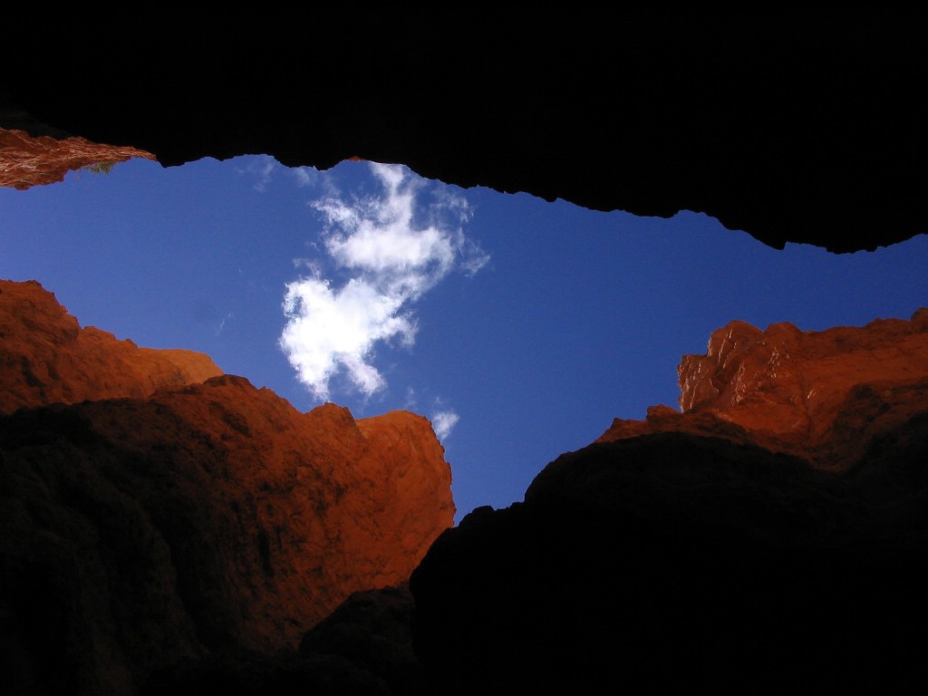
Another slot canyon, this one at Bryce Canyon.


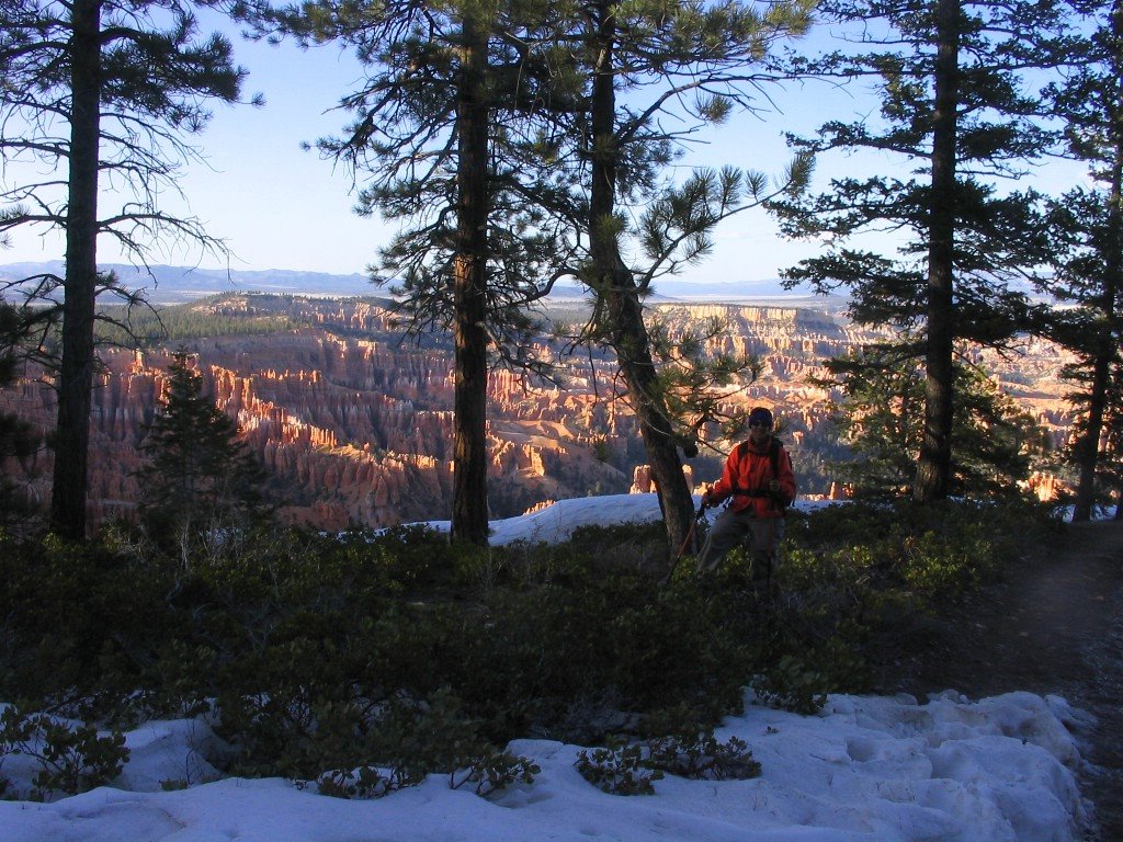
There was still snow at the higher elevations in Bryce in mid-April -- this part of the park is at 8300 feet -- the "Silent City" is in the background:


This is a better view of the Silent City on a cold, clear, windy late afternoon -- we could literally see for a hundred miles:


"Hoodoos" at Bryce.


More hoodoos, backlit.


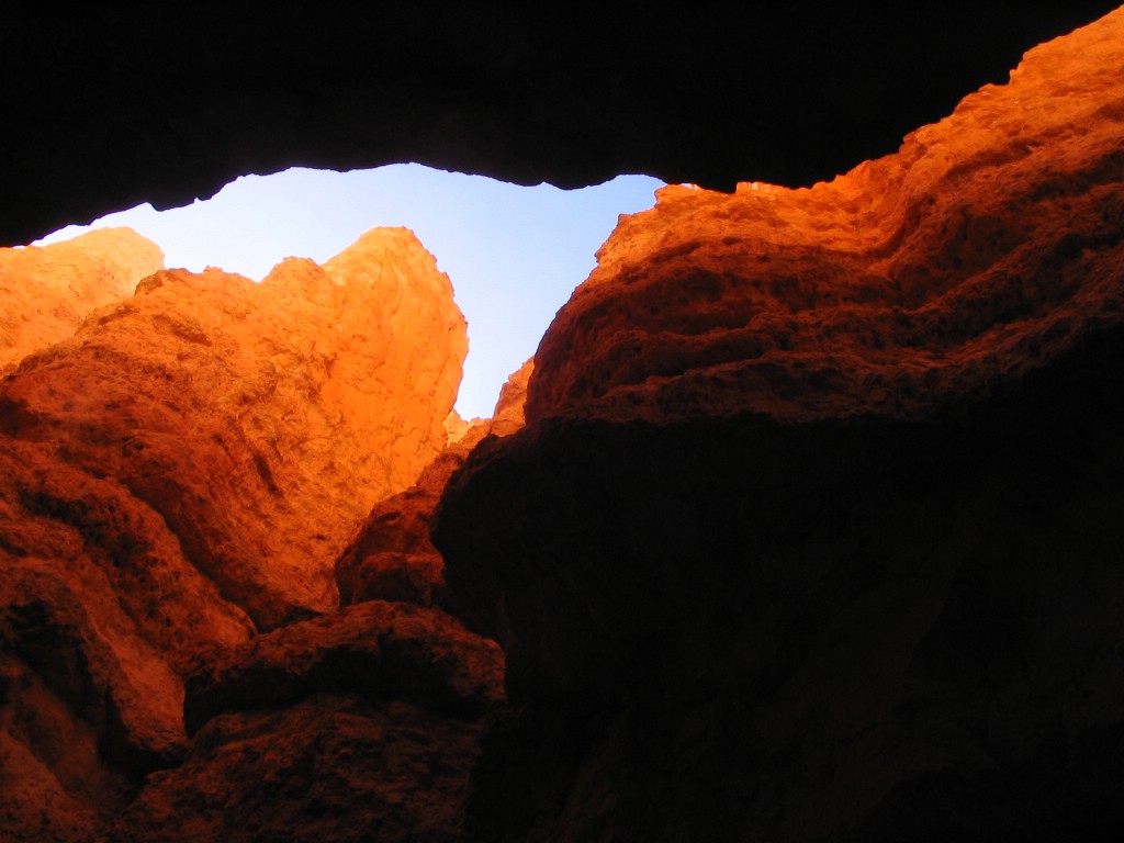
Slot canyon, looking up. There was ice on the floor of this one, covered with a thin layer of mud.


This is almost the same shot, edited years later in Lightroom:


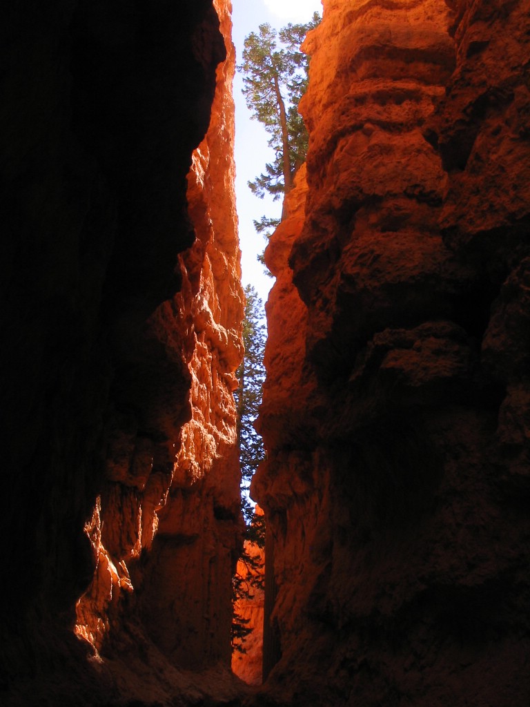
Slot canyon, looking sideways.


In Zion, the biking was great -- the main canyon road in Zion prohibits cars, and the shuttle buses were not a problem. This is one of the greatest biking roads we have ever been on.


This archway is more than a thousand feet high. It's called a "blind arch" because it is not cut all the way through the mountain. The sheer walls of Zion are created when the river cuts into the softer layers of sandstone toward the bottom of the strata. The top layers, which are harder, resist the undercutting as long as they can and then peel off in huge sheets:


One evening, we rode from the campground on the bike path that follows the river -- this is the Watchman in the late evening light:


In 2013, I added several shots that did not make it the first time -- these are "sand pipes" in Kodachrome Basin -- they are fossil geysers:


This is Calf Creek Falls:


And this is the Zion area, shot from the Canyon Overlook trail, looking west: