Thursday, March 12, 2020

Skiing While Boondocking: June Lake, March 2020

"This is going to be uniquely procedural."  That is what we predicted when we decided to combine boondocking (camping in the national forest, not in a campground) and skiing in the same trip, something we had never done before.  Each activity requires a lot of gear and a lot of preparation.  Taken together, they were, well, uniquely procedural.  But in a good way:  the trip was a success!

March 1:  We stopped for the first night at Keough's Hot Springs, south of Bishop.  They have a campground with electric hookups, and their main building encloses a warm pool (90 degrees) and a hot pool (104 degrees).  The facilities are best described as "funky:"  the building dates from around 1919 and has not been altered much since that time.  But it was pleasant to hang out in the hot tub after a long drive.  Many of the other customers had come from Mammoth to soak in the tub after skiing and before driving back to Southern California.

During the night, fresh snow fell in the higher elevations -- almost a foot at Mammoth and June.

March 2:  We spent the day looking for boondocking.  (This sounds like a chore, but it's actually a lot of fun.)  Our goal was to find something not too snowy and not too far from June Lake.  The Inyo National Forest's motor vehicle use maps showed the areas that were open for boondocking; I had then used Google Earth to preview each potential site, had saved the images on my phone as jpegs, and had dropped precise waypoints on our ihikeGPS apps to provide real-time phone guidance.  (It sounds like a lot of work, and it is, and yet it is part of the fun, too.)

We first looked at sites in the area around Deadman Summit and Obsidian Dome.  Although the main forest roads were generally free of snow, the spur roads were not.  The campsites (mostly above 7500 feet) were just a little too snowy for safety.  We parked the car and hiked into the back country, but there were drifts more than a foot deep in many places.  Too risky -- getting the truck or the trailer stuck (or both!) would be very expensive.  Nope.  (A wise person once told me, "The term '4x4' means 'you will still get stuck, just a quarter mile further from the pavement.'")

We then looked at a boondocking area near Mono Lake, the Aeolian Buttes.  The sites were just below the snow-line, at around 7100 feet.  But the sites were rather bleak and dusty, there were limited views of the mountains, and the soil was mostly pumice.  Nope.

We finally looked in the area north of June Lake and south of Lee Vining.  (I can't be more specific than that.)  Bingo!  We scored a great site west of the highway, with a 180 degree view of the snowy east side of the Sierra.

Access to the campsite was pretty tricky:  the primitive "two track" access road was so narrow that the thorn bushes scratched both the truck and the trailer (more Sierra pinstripes!), and then we had to do a tight three point turn and back the trailer up a steep sandy hill to a very small semi-level pad.  A trailer any bigger than ours (12 feet) would not have fit into that spot.  My handy Hitchball Wizard guided me right into place, easy as pie.  (I don't know how she does it, but I am very grateful.  She waves her hands and I just follow her directions.)

All of the nearby peaks looming over us were 12,000 footers:  from south to north, we could see Carson Peak, Parker Peak, Parker Canyon, Mt. Lewis, Mt. Gibbs, Mono Pass, Mt. Dana, Tioga Peak, and Lee Vining Peak.  The cold late-afternoon wind was howling out of the northeast, blowing the fresh snow off the ridges:


After we got the trailer stabilized and arranged and all of our equipment secured, it was time for a snack.  This was the evening view from the dinette table, inside the trailer -- that's the window frame at the top of the shot:


The cold weather gave us a perfect excuse for hot chocolate laced with a shot of Bailey's Irish Cream and a splash of Kahlua, a ritual that we enjoyed every afternoon before dinner.  (Just because we are "camping" does not mean we have to suffer!)

That first night was the coldest of the week, probably into the mid-teens.  We were plenty warm (a down comforter and several blankets), and our heat cables kept the fresh water tank from freezing.

March 3:  It was 31 degrees inside the trailer when we woke up.  We took the foam pad off the front window, hoping to see the sunrise on the mountains.  This is what we saw:


Yes, that is ice on the inside of the window, and it did not want to come off.  So, Plan B -- go outside and look at the sunrise:


After breakfast, we stepped outside with our coffee:


A little later that morning, on our way to June Mountain, we got a shot of the trailer with Mono Lake to our northeast, in the background.  The trailer is to the left of the middle of the photo, a little white box in a sea of sagebrush:


The skiing was a pleasant surprise -- we had expected patchy snow because of the dry winter, but the combination of snow-making equipment and the recent storm had created perfect conditions, with a thin layer of soft snow over a firm base.  There was almost no one else on the mountain:


We really enjoyed the intermediate runs, cruising on the corduroy in a leisurely fashion.  Far from epic adventure, but just fun:


That evening, as we returned to the trailer, we grabbed this shot of the backside of the campsite.  The trailer is in the middle of the photo, just to the right of Parker Pass:


March 4:  This is a "morning version" of the previous shot:


We started the day at Obsidian Dome, walking with our microspikes over the icy, crusty snow.  The microspikes were great on the solid ice.  Not on the snow, though.  It was so warm that the snow would melt and refreeze underfoot, creating huge awkward clumps of icy snow that made it difficult to walk:
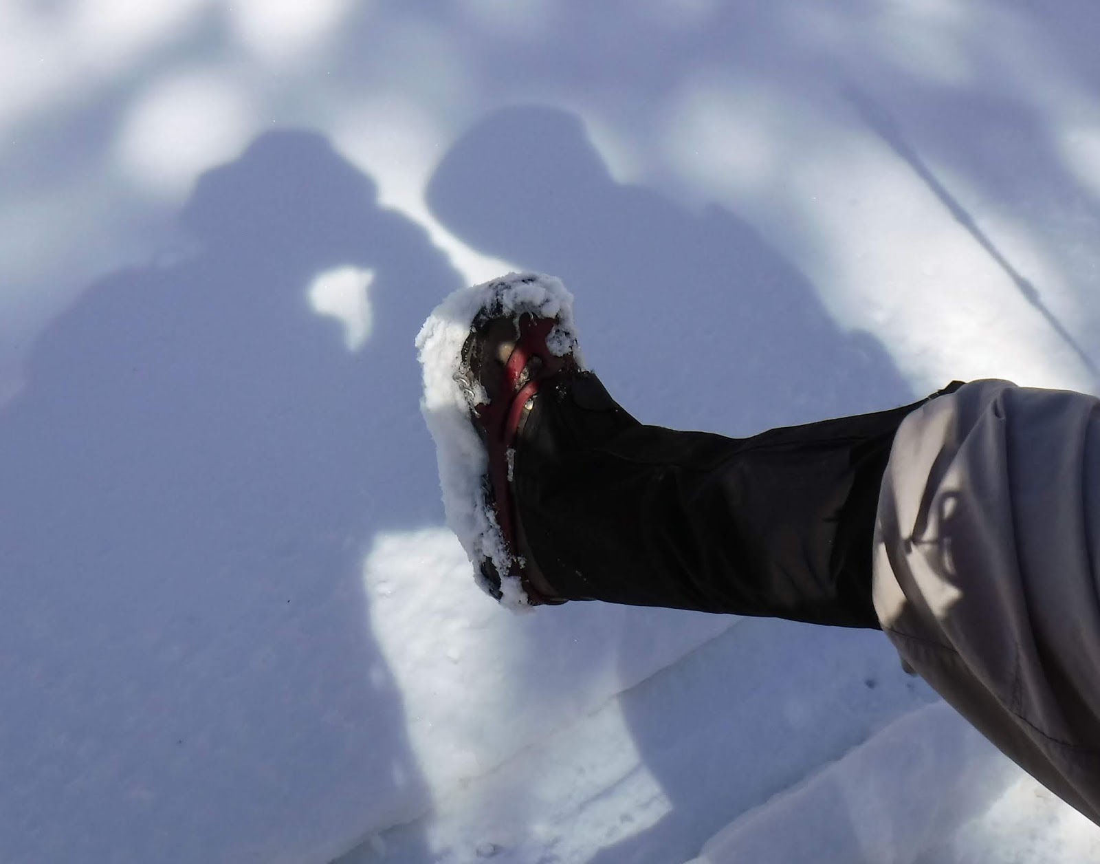

We had experienced the same clumping phenomenon when using snowshoes in similar conditions.  We had hoped that microspikes would be the magic bullet.  Nope.

So, Plan B.  We drove into Mammoth Lakes, looking for a source of fresh water.  (We actually had plenty of fresh water in our holding tank, but we wanted to fill one more jerry can just in case of an emergency.)  The ranger at the visitors' center told us that there were no outdoor water faucets operating anywhere because they would freeze at night.

We asked her whether we could fill our jerry can from the faucet in the restroom, and she said we could.  But the problem, of course, is that the bathroom sink faucets were not made for filling jerry cans; the water emerged from stubby little openings, with no way to attach a hose.

Back to the truck -- what to do?  Felice spotted an empty 16 ounce plastic water bottle in the cargo bed of the truck and grabbed it. (This was a minor miracle -- we almost never have plastic bottles in the truck because they get put into the recycling bin.)  I said, "Wait, that's no good.  It'll take us a year to fill the little bottle, pour it into the jug, refill the bottle, and so on."

She smiled, already having developed a MacGyverish scheme.  There was a hose in the truck that I had brought to fill the jerry cans.  She screwed the plastic bottle into the hose fitting -- it fit perfectly!  (That was a major miracle -- what are the chances that the bottle would fit the hose??)  She then used the scissors on her Leatherman tool to cut a slice off the bottom of the water bottle, creating a sideways funnel.

Back to the bathroom -- success!


And a MacGyver selfie in the mirror:


After that triumph, we headed out to the Lake Mary area, hoping (correctly) that the snow had cooled off enough so that clumping would no longer be a problem.  We walked out toward the lake, first passing a road sign.  Here is the sign in late April of 2017:


And this is what it looked like in early March of 2020:


That's a seven foot difference in the snowpack.

We walked to the edge of frozen Lake Mary.  The area behind us on the left is the Mammoth Creek/Duck Pass drainage, a familiar destination during our summer hikes:


On our way back to the trailer, we grabbed a pizza at June Pie -- a very rare event.  Pizza!  We ate the whole thing, something we've never done before.  Very memorable.

That evening, I once again tried to capture the essence of boondocking in a little trailer in the middle of nowhere:


The moon was almost full and illuminated the mountains.  Even with the moon, the stars were surprisingly bright -- Orion is in the top center of this shot, just above Parker Peak:


March 5:  We went back to June Mountain for another day of skiing.  Carson Peak was reflected in June Lake -- the ski resort is on the left side of the shot:


The mountain was, if anything, even emptier than it had been a couple of days earlier, but the snow was still excellent:


We were treated to a spectacular sunset -- these are lenticular clouds:


And yes, that is exactly the way it looked.  This is not a trick shot.

March 6:  The day started with yet another sunrise photo -- I can't resist those shots:


Even with a wide-angle lens, it was not possible to get a complete panorama:


We hiked to Parker Lake, to take advantage of the unusual fact that the forest roads were open while the mountain was still snowy.  For most of the day, we were the only people on the trail.  The trail was intermittently icy and dry, so we had to take our microspikes off and put them back on a couple of times.  Not a serious problem, and we were very glad to have them on some of the icy, steep traverses.

Up at the lake, a cold wind was howling down Parker Pass.  The lake was partially frozen:


Felice decided that a black and white version would be a proper homage to the surrounding Ansel Adams Wilderness:


We returned to the truck in the mid-afternoon and had time to take a walk on Tioga Road, which was closed to traffic but snow-free:


And this is what the same place looked like almost exactly a year ago:


March 7:  A snowstorm was rolling in over the mountains while we were packing up to go home.  No problem -- we just bundled up and took care of our chores.  We rolled out just before the storm hit, but we were sorry to leave this campsite:


(Post-script:  just after we got home, the coronavirus pandemic hit the U.S., and the "shelter in place" orders were published.)

Tuesday, February 25, 2020

Southern Sequoias: February 2020

(Click on the photos to see a slideshow, and hit "escape" to get back to the text.  Both of us took these photos.)

February 11:  We took a long drive from Potwisha Campground into Mineral King on a very slow and twisty road.  It was almost 90 minutes from the trailer to the trailhead; but then again, we had the entire mountain range to ourselves.

About halfway up the road, there is a gate that is locked in the winter.  (We had gotten the combination from the ranger at Foothill Visitors Center.)  The gate is tricky to open:  the lock is hard to reach, and the bolt is balky.  But if you want solitude, you have to put up with some difficulties.

The road ends (in the winter) at another locked gate two miles from Atwell Campground, so we had to walk on Mineral King Road to the trailhead for Paradise Ridge.  There were quite a few Sequoias along the roadway:


(In each of the photos of the Big Trees in this post, look carefully at the  base of the tree to get a sense of scale -- you may have to click on the picture to see the person!)

When we got to the turnoff for the Paradise Ridge trail, the route began to climb steeply.  The guide books describe this part of the trail as shaded, but that was before the bark beetle infestation destroyed many of the pines.  The good news is that the Sequoias are apparently impervious.

The most striking thing about this isolated trail is that there were no footprints at all, even though the soil was soft.  Perhaps since the road was closed in October, we were the first folks to have hiked this trail since the autumn months, so the rain and the melting snow had erased any traces of last year's boots.

After a mile or so of climbing, we reached a very dense grove of Sequoias:


Not far from the Sequoias, we came across the biggest pine cones we have ever seen, about two feet long:


A little research later revealed that sugar pines produce the largest pine cones in the world, up to 26 inches in length.

The guide books also said that there would be views of the Great Western Divide from the trail, but we were not able to see the high country skyline.  However, there were pleasant views of the snowy Mineral King drainage:


Ironically, some of the best views were from Mineral King Road itself.  The triangular mountain on the left is Sawtooth Peak, over 12,000 feet high:


Overall, we concluded that this hike was worth doing once, just to experience the novelty of having an entire Sequoia grove all to ourselves, with no one else within 20 miles of us.  Absolute silence, all day long. But the "commute" (90 twisty minutes each way) was pretty daunting.

February 12:  We headed up to the Giant Forest area, intending first to drive out to Moro Rock and then to hike among the big trees.  But the road to Moro Rock was closed due to ice and snow.  No problem -- we turned it into a hiking trail!  This enabled us to see the Sequoias along the road, which are usually hard to see from a car:


As one might imagine, there were very few people hiking to Moro Rock.  The climb up the rock was not difficult -- there were handholds and steps, with hardly any snow or ice.  And the view of the Great Western Divide was terrific:


The road past Moro Rock toward Crescent Meadow was also closed.  We came across this tight group of "three sisters:"


We took the Bear Hill Trail back to the General Sherman Tree area, and we were once again completely alone for the rest of the hike.  Heading down the highway back to the campground, we got a good view of Moro Rock at sunset:


The big trees at the base of the rock provide some sense of scale.

February 13:  We hiked to Marble Falls; the trailhead was at the campground, so there was no long commute.  The trail was surprisingly warm for a day in February, and the climb was steady but not too strenuous.  After a couple of hours we almost reached the falls, but a recent rockfall had made it impossible to get all the way to the falls.

We enjoyed lunch next to a cascade:


Many of the boulders in the canyon were covered in a crystalline deposit -- I think these are calcite crystals:


Speaking of geology (as I often do), the photo below contains a fun mystery, which I think I might have solved.   This is obviously a sedimentary bed of sand that has been tilted from the horizontal to the vertical.  Along the way, it was then lightly "cooked" by metamorphosis (heat and pressure) and is now sandstone.  The layers are a little wavy after having been cooked.  The outcropping has later been eroded away, pitted by the water of the stream.  Look at this shot and see if something weird jumps out at you:


What's that zig-zag running across the top of the shot?  It is about six feet long and about an inch and a half wide, give or take.  Clearly, it was created after the sedimentary strata were deposited, because it bisects the strata.  It looks like a snake's tunnel, but it seems unlikely that even the most vigorous snake would have penetrated so many layers of well-packed sand.  It's not a fault -- there is no offset of the strata. 

I think it might be a fulgurite:  a fossilized lightning strike!  When lighting hits sand, it sometimes happens that the sand is fused along the path of the strike, creating a long, thin vein of quartz-like rock.  If my guess is right, this happened while the sand was still horizontal (and possibly moist and uncompacted).  It would be a lot harder for the electricity to flow through dry or dense sand.

Going further out on my limb, I think the strike occurred on the right side of the photo, because the area of fused sand is much thicker on the right side than on the left.  After the strike took place, the top of the sandbank (on the right) was then buried by additional deposition.

(End of geology lecture.)

The trip back down to the campground was uneventful, but we were greeted by a group of very tame deer:


The campground was very quiet all week long -- there was almost no one else around. 

February 14:  Even though it had been a warm and dry winter, we just had to do some snow hiking up on Little Baldy.  We strapped on our microspikes and had no difficulty with the ice on the switchbacks:


This "boot shot" of the Great Western Divide includes the red straps of the microspikes:


Up at the summit, we decided to re-enact a famous family photo from 1991.  This is the original:


And the copy:


(I guess you had to be there.)

As is often the case, we had the whole mountain to ourselves for several hours:


Later that afternoon, we paid a quick visit to the Congress Grove area and headed up the Alta Trail for a while:


At the end of the day, the obligatory "tree trunk wishes" were carefully made:


Tuesday, October 15, 2019

High Country of the Eastern Sierra: September 2019

(Click on the photos to see a slideshow, and hit "escape" to get back to the text.  Both of us took these photos, and then I edit them.)

After a difficult summer (for many reasons), we just wanted to unwind and relax.  No epic adventures.  The camping equivalent of "comfort food:" something familiar, pleasant, and restorative.  The choice was obvious: the high country of the Eastern Sierra.

September 21:   We spent the first night at Horton Creek Campground, northwest of Bishop, a BLM facility.  It was surprisingly busy, but we managed to snag a campsite on the uphill edge of the campground, with the entire Bishop Creek drainage as our background:


 Even though we were within a few miles of Bishop, the Tungsten Hills blocked the lights of town; the stars were excellent.  That's Jupiter on the right side of the Milky Way:


 In this shot, I tried to "paint" with an old incandescent flashlight (which has a better color temperature than an LED light does), in an attempt to create some foreground interest.  The experiment was semi-successful.  The technique needs a little work:


September 22:   The early morning sunlight picked out the colors and the texture of the mountain range.  That's Mt. Tom on the right side:


That morning,  the forecast was for mild weather all week; so we took a chance and headed up Tioga Pass to Tuolumne Meadows in Yosemite, to see if we could snag a first-come-first-served campsite.  Much to our surprise, there were plenty of campsites available.  This was the last week that the campground would be open, and apparently demand drops off at the tail end of the season.

The campsite was very pleasant, as campgrounds go.  (It ain't boondocking!)  But it was quiet, most of the time, and relatively uncrowded.  Plus, the campground is very well-located, saving us from having to make a long "commute" up from Lee Vining to the high country trailheads.

After getting the campsite set up, we went for a leisurely hike along the Lyell Fork of the Tuolumne River, as far as the footbridge.  The lighting was unusual.  Although the late-afternoon sky to the west was cloudy (and we were in open shade), the sky to the south was not; thus, the reflection in the stream was a particularly intense peacock blue, not washed out by direct sunlight.  I took this shot at 1/10 of a second in order to smooth out the reflections:


September 23:   We took the Cathedral Lakes trail, about 9 1/2 miles with about 1700 feet of gain.  The views of the Cathedral Range kept changing as we circled the base of the mountains.  The peak was reflected in the stream leading to Lower Cathedral Lake:


The rim of the lower lake is composed of glacially-polished granite:


After stopping off at the lower lake, we made it up to Cathedral Pass.  That's Upper Cathedral Lake on the left, with the peaks of the Hoover Wilderness in the background:


September 24:  We took the North Dome trail which is also about 9 1/2 miles with about 1700 feet of elevation gain and loss.  Most of the trail is unremarkable, but there is one very short pitch with poor footing and a sheer granite face.  We went down (and up) that part of the trail while sitting down.  It's only about a 5 foot span, but one would think that the Park Service would create a couple of steps in the middle for folks who are not expert rock-climbers.

But of course, it was worth the effort.  North Dome sits right across Yosemite Valley from Half Dome:


September 25:  We packed up and moved to a boondocking site north of Lee Vining, in search of silence and isolation.  We spent some time positioning the trailer, in an effort to maximize the view from the front window.  Mono Lake is on the left in the distance, and that's Boundary Peak (about 13,000 feet) on the horizon:


That evening, it was warm enough to sit outside and watch the mountain shadows race across the desert, far below us:


It is impossible to capture the wonderful sensation of being all alone in a very small trailer at the edge of a silent forest at 9500 feet on a cold dark starry night.  This shot is yet another attempt to bottle that feeling:  


September 26:  Soon after leaving the Lundy Canyon trailhead, we came across a fairly recent debris field.  I'm not sure if this qualifies as a rockslide or flash flood debris, but it was a mess.  The flow originated in the orange-colored ravine in the middle of the shot:


For the space of about a hundred yards, the aspens had been completely wiped out.  On either side of the main flow, there was a lot of talus and gravel choking the trunks of the remaining aspens.  After a little Googling, it looks like this took place in July of 2018 as the result of heavy monsoonal flow.

But some aspens are lucky enough to grow in well-protected areas.  The oldest aspens in parts of Lundy Canyon are almost four feet in diameter:


The light was just perfect --  crisp, clear, autumnal:


We hiked up to the cascades:


This shot looks riskier than it was:


There was an odd berry bush near the cascades:


You'd have to be of a certain age, but doesn't that look like Barney Google?


September 27:  We took a leisurely hike up to Green Lake.  At the lower elevations (but not the upper??), the aspens were at peak color:


We came across some freshly-cut aspen.  The tip of the pole shows that these trees were at least a foot thick.  Maybe someday, we will see a beaver in action:


Up at the lake, it was windy and cold.  Green Lake was not green; it was a vivid mix of slate blue and aquamarine:


September 28:  It had been a very windy night.  The forecast was for gusts up to 60 mph, and there might have been a few of those.  Every so often, the trailer would shake as though a 5.0 earthquake had just hit nearby, even though we had the stabilizers deployed.  The wind was howling and moaning.

We peeked out at the sunrise -- there was a big dust storm on the other side of the lake:


This is a zoomed-in view of the dust cloud:


Back to bed, and we slept till 8:30 (!), a rare treat.  Instead of hiking, we spent the morning getting ready for the predicted change in the weather:  a dusting of snow, with more high winds.  All of our equipment was covered with tarps, anchored with big rocks.  To eliminate the midnight earthquakes, we also set up the truck as a windbreak for the trailer, parking it very close to the trailer and across the path of the wind.  (Spoiler alert -- it worked!)

In the afternoon, we hiked around on the nearby forest roads, checking out other potential boondocking sites.  One site, on a high ridge, overlooked our campsite from a couple of miles away.  The trailer is the small square white object in the center of the shot.  The storm clouds were visible to the far north:


The late afternoon was very cold (below freezing) and windy.  The trailer's doorframe is on the left side of this photo:


That evening, we rigged up our DIY hot water recycling tube (which shunts hot water into the fill port of the fresh water tank), along with our new Ultra Heat cable.  The heat cable wraps around the drain tube at the bottom of the water tank, which is the most vulnerable point in the water system.

This was our first time using the heat cable -- success!  Despite night-time temperatures below 20 degrees, the water system did not freeze.  And the current draw (about two amps for about ten hours) was well within the reserve capacity of the battery.

The night was as windy as predicted, but the truck protected us from the heavier gusts.  There were snow flurries all night long.  Unlike rain (which makes a gentle tinkling sound on the roof), snow is almost silent.  But the trailer was so quiet that we could sometimes hear the snow hitting the roof and walls.  Indescribably pleasant. 

September 29:  The temperature inside the trailer was just slightly above freezing when we awoke.  We were perfectly comfortable with a down comforter and four blankets, so it was almost impossible to get out of that nice warm bed to watch the sunrise on the fresh snow.  We did it anyway:


The clouds over the mountain were reflecting the dawn:


The truck, patient, humble, and sturdy, is entitled to credit for protecting the trailer from the brunt of the storm.  Note the wipers pulled away from the glass so that they would not freeze to the windshield.  Please do not ask how I learned that trick:


(By the way, not to worry:  although we watched the sun come up over the snowy landscape before 7:00, we forced ourselves to go back to sleep till after 8:00, an extraordinary luxury.)

This next photo may be my favorite shot of the trip, not because it is so lovely but because it means that we were warm and dry at the breakfast table, drinking our fresh-brewed Starbucks, looking out at several inches of new snow:


After yet another uncharacteristically leisurely morning, we headed up the Virginia Lakes trail, mostly to see the familiar canyon with a fresh dusting (something we rarely get to see).  We stopped at the old miner's cabin:


This is Cooney Lake:


This is Teapot Lake, I think.  The new snow really accentuated the strata in the metamorphic "roof pendant" above the granite:


The wind sweeping down the canyon had whipped freezing spray off the lake, creating a display of dagger-shaped icicles:


September 30:  We left the Lee Vining area and looked for a campsite further south, closer to the Rock Creek trailhead.  We first checked out McGee Creek campground, which seemed kind of bleak -- no shade, fully exposed to the wind.

We then toured the East Fork campground on Rock Creek, but it was poorly laid out -- tight roads, too many campsites shoehorned into one small area.  With so many sites in such close proximity, there would be no escape from the inevitable early-evening generator concert.

We finally chose Big Meadows campground, not far downhill from East Fork.  Because we were using the heat cable every night to keep the water lines from freezing, we needed somewhat more juice than usual.  Each morning, we would take the depleted battery out into the nearby sunny meadow where we had deployed our solar panel.  By the end of each day, the battery was back to full strength.  (Note -- "depleted" does not mean "dead."  The battery never got below 12.1 volts while resting, i.e., a 50 percent state of charge.) 

October 1:  The main reason we stayed in Rock Creek Canyon was to get an earlier start than we usually do when we have to "commute" to Rock Creek from Bishop.  Did we?  Nope.  Slept late again.  No excuse, other than CDTS ("Cold Dark Trailer Syndrome").

Because the trailhead is at 10,200 feet, the two-day-old dusting of snow was still largely intact on the surrounding peaks:


The views kept improving as we approached the Gem Lakes area at around 11,000 feet:


I think the beige stripes in the cliff face in the upper right might be quartz veins.  I doubt that they are metamorphic strata because they are not even remotely parallel. 

Gem Lake was sparkling in the afternoon sunlight. The stripes in this particular headwall do look metamorphic, unlike the chaotic veins in the prior shot.  Note the large snowfield in the lower left, a stubborn remnant of the heavy winter:


This is one of those lucky shots -- the lighting and composition arranged themselves.  It really captures the feeling of this magical valley on a chilly, breezy late afternoon in early autumn:


October 2:  We have taken the McGee Creek trail several times, but it always seems too hot and shadeless.  This was an exception, cool and windy.  The fall color began about two miles up the trail from the trailhead:


There were icicles in the streams -- this ice-encrusted branch looks like a Henry Moore sculpture, or maybe one of Modigliani's ladies:


Geology fans (and aren't we all??) will recognize this as an intricately-layered metamorphic sequence, vertically tilted a full 90 degrees:


We didn't get as far as we'd hoped, because the bridge at the three mile mark was still out.  (We assumed, incorrectly, that it had been repaired.)  Next time, we will have to ask the Ranger in advance.

But we did get within sight of a familiar flat ridge, high atop the range.  This is what it looked like in dry weather:


And this is what we saw a few years ago, during a snowshoeing trip.  This is the same ridge, covered in deep concave cornices:


Overall, the trip was exactly what we needed:  relaxing and unpressured.  Lots of "unstructured" time, long leisurely meals, quiet evenings reading, hot chocolate with Kahlua, recreational carbohydrates.  Not exactly a Spartan existence.  At the same time, the trip was physically demanding, not only because of the hiking but also because we were camping in freezing weather.