(Note -- since this blog post is very long, I have organized the entries by date. Feel free to skip around -- some of the detail is just for our own records. And remember that you can click on the pictures to enlarge and then hit "back" to get back to the blog.)
Wednesday, July 21: We drove to Stockton and called Kim, Felice's college roommate, on a last-minute whim. We enjoyed cocktails and dinner, and she generously gave us a mixed case of really excellent red wines -- we enjoyed the wine every night for the rest of the trip! This shot is a little out of focus, but it preserves the moment:

Thursday, July 22: We drove through Redding to Klamath. We discovered that Highway 299 is long and twisty, and it would have been better to cut over to 101 on Highway 20. That evening, we hiked along the coast on a cliff overlooking the Klamath River estuary; the resident pod of gray whales was enjoying the sunset as much as we were.
Friday, July 23: We hiked the James Irvine Trail in Prairie Creek State Park to Fern Canyon and back. This was a very long hike, with classic redwood groves. (I haven't included our photos of the redwoods in the Prairie Creek area. Ironically (or perhaps paradoxically), the trees were so dense, and the foliage so lush, that the photos weren't that great: it was too shady, and there was no way to get much of a perspective on the huge trees because there were too darn many of them!)
Saturday, July 24: We hiked the lovely Brown Creek Trail in Prairie Creek and then the Lost Man Creek Trail (which was not as lovely).
Sunday, July 25: We hiked the Boy Scout Trail in Jedediah Smith State Park, up near Crescent City. The redwood groves in this area were particularly beautiful, perhaps because they were not quite as dense as the groves in Prairie Creek:

We turned around at Fern Falls:


Monday, July 26: We drove to Vancouver, Washington.
Tuesday, July 27: As we were driving from Vancouver up toward northern Washington, Felice called the ranger station in the Mount Baker area to check on conditions. The ranger reported that there was still 15 feet of snow on the trails! So, on the spur of the moment, we took a sharp right turn to Mount Rainier and ended up spending the next 10 days there. We just could not tear ourselves away from the views of this magical mountain.
We camped in Ashford at Mounthaven RV Park, which was very close to the Nisqually entrance to the national park. On that first afternoon, we took a steep hike to Lake Christine. The mosquitoes were fierce, but the avalanche lilies were poking up out of the snow and mud:

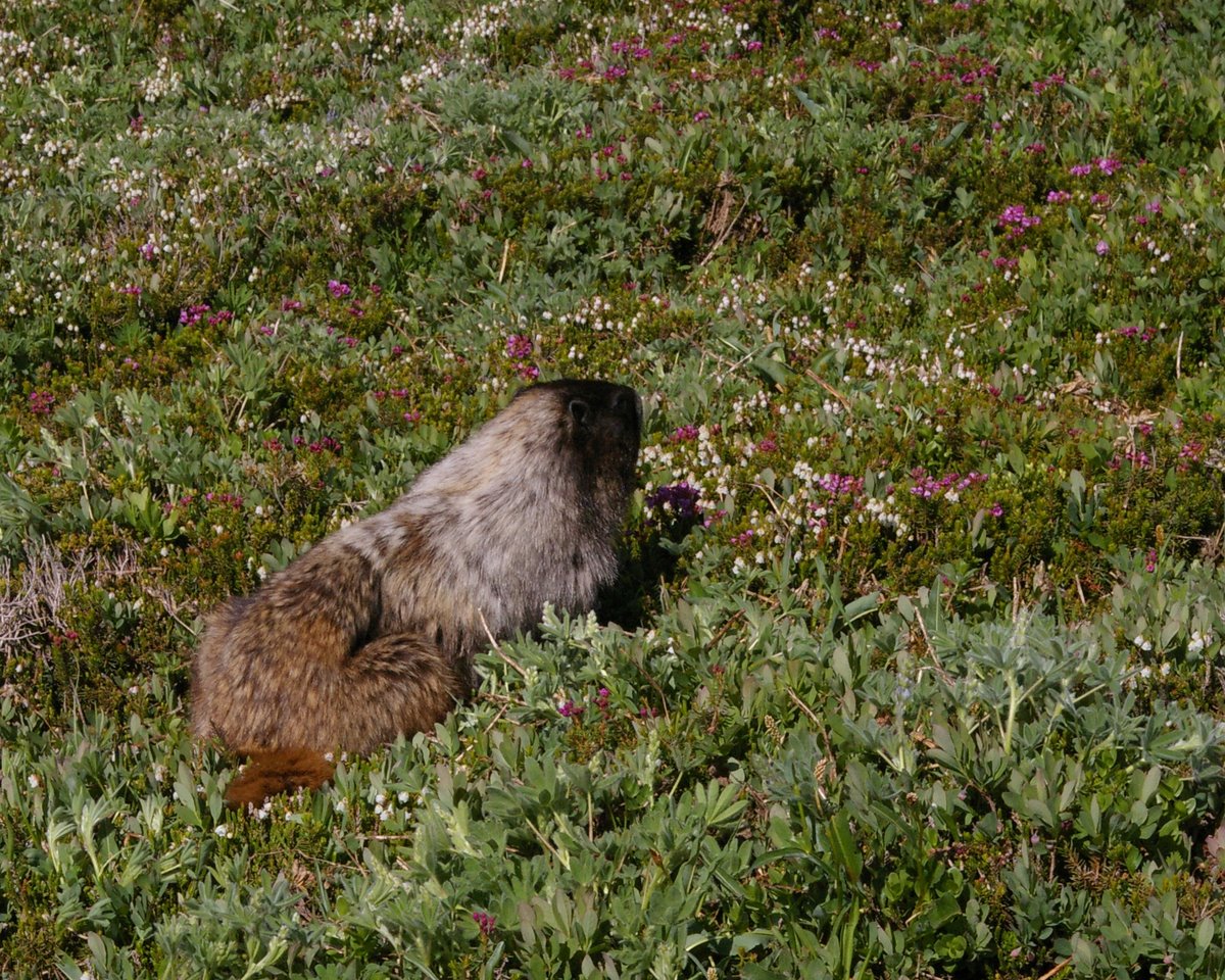
Wednesday, July 28: We hiked in the Paradise area of the national park, up to to Panorama Point and the Muir Snowfields (at about the 7200 foot level). The route was a little bit tricky -- there were some icy chutes. Along the way, we were greeted by the obligatory marmot:
It was really exhilarating to get up so high on the mountain:

The mountain was very clear for almost our entire ten-day stay, which is apparently somewhat unusual. There were terrific views of Nisqually Glacier:

Thursday, July 29: We hiked up to Comet Falls. Just before arriving at the main falls, we came across this unnamed fall on Falls Creek, with a whirl of spray backlit by the morning sun:

This is a similar shot, edited more than three years later in Lightroom:

Further along, Felice clambered down to the foot of Comet Falls. I stood back, away from the spray, to take her picture:

This is the same shot, edited three years later in Lightroom:

I could see that she was getting soaked; she seemed very excited, shouting and waving her arms. As she climbed back up, she was yelling she had been completely encircled by a brilliant double rainbow at the foot of the falls. I put down my equipment and my backpack and hiked back down with her. It was true: a double circular rainbow! As best we can figure out, this rare phenomenon was caused by a lucky combination of circumstances. First, we were at the falls right around noon in the summertime, so that the sun was nearly overhead. And instead of developing a deep plunge pool, the falls had filled in at the bottom with a boulder field, so that the spray shot out in a horizontal plane, surrounding us (and soaking us). The high sun angle, together with the horizontal sheet of spray, caused the circular horizontal rainbow. In addition, since the sun was so bright, the light within the rainbow was refracted twice, causing the double rainbow. Even though there is a rational explanation, this seemed like a miraculous phenomenon.
After getting thoroughly wet, we continued our steep climb up toward Van Trump Park, which is a fairly level meadow far above the falls. A group of aggressive gray jays (sometimes called "camp robbers" or "whiskey jacks") tried to take our peanut butter sandwiches right out of our hands. They didn't succeed, but they posed rather nicely while waiting for a chance to steal our food:

Feeling adventurous, we continued further up to Mildred Point, which was a very steep climb -- we had to use our hands at times. (But this was not a rock scramble -- the trail was loose dirt.) This portion of the trail was right at the limit of our abilities. (The entire hike was roughly 8 miles, with well over 2000 feet of elevation gain.) On the trail back from Mildred Point, we could see lenticular clouds forming over the crest of the mountain. These are essentially "standing waves," where the moist air condenses in the cold air at the top of the mountain. The cloud stays in one position, even though the wind and the moisture are continually streaming up and over the crest:

Parts of the trail were lined with bear grass, which apparently is actually eaten by bears:

Friday, July 30: Starting at Cougar Rock campground, we hiked to Carter, Madcap, and Narada Falls, ending at Reflection Lake, another long and steep hike. Felice was content to hang out above Madcap Falls while I played around with long time exposures:

The rainbow at Narada Falls was very intense:

This is the same shot, edited three years later in Lightroom:


In the late afternoon, the Nisqually River was in full flood, carrying meltwater from the foot of the glacier. We discovered that streams grew substantially during the course of the day, as the volume of meltwater increased:

Saturday, July 31: We hiked to Paradise Glacier. Although the Paradise area was very crowded, we quickly left everyone behind by venturing out onto the snow with our microspikes, which are light-duty crampons. It felt like our feet were suddenly equipped with four-wheel drive -- no more slipping on icy slopes! These devices were so helpful that we had to guard against overconfidence, which could have gotten us onto some dangerous slopes. The microspikes fit over the boots very easily:

Amazingly, we were all by ourselves at the edge of the glacier:


Below us, the fog and low clouds drifted in and out; the rugged Tatoosh Range (just south of Rainier) is visible through the clouds in the lower left corner of the picture:

On the lower portion of the trail, back in the clouds, the magenta paintbrush were popping up everywhere:

We frequently came across the pasque flower. Here is the flowering stage of the plant, which is not particularly remarkable:

But the seed head is really odd (and funny) -- it looked to us like the Lorax by Dr. Seuss. A ranger called it a "mouse on a stick":

Sunday, August 1: We drove from the southwest side of the mountain around to the north side. The road from Paradise down toward Stevens Creek was very rough; some of our cabinets opened, spilling clothing into the trailer, which has never happened before, even on rough dirt roads. (When the sign says "Rough Road" in Washington, believe it!) We scored an amazing "pull through" campsite in White River Campground, right on the river. The river itself was very wild: milky-white glacial melt roaring through a canyon of big boulders:

That afternoon, we first tried to hike to Emmons Moraine, but the trail had been washed out by a flood and we couldn't climb up the very steep rocky bank. Instead, we hiked up to Glacier Basin, which was a lovely meadow full of not-so-lovely mosquitoes. As we were hiking back down, I saw a bear cub emerge from the bushes in a meadow below the trail. We stopped. The mother and another cub soon joined the first one. This picture may be worth clicking on -- the cubs are looking right at us, very alertly:

We had to wait on the trail for quite a while, not wanting to cross anywhere near the mother (who seemed to be taking no notice of us). Eventually, the cubs ran off into the woods:

Sunday, August 2: We took a long hike to the Summerland area, which looked very much like the countryside in the "Sound of Music":

Above Summerland, we headed through the snow toward Panhandle Gap. The snowfields were melting rapidly, and creeks had cut down through the snow:

The snowfields were piled up against the rock ridges like enormous sand dunes:

The crest of the mountains had been scooped out by glaciers, leaving huge sunny cirques. If you enlarge this picture and look carefully at the snow near Felice, you can see pink snow -- this is caused by algae that grow at high altitudes during the summer:

Looking west toward Emmons Glacier, we could see another wave of lenticular clouds beginning to form above the peak. I think these clouds were sponsored by Nike:

After a strenuous hike, it was very pleasant to kick off our boots and enjoy our usual cocktail hour at our campsite, overlooking the river. Gin and tonic and lime, with three real ice cubes from our little freezer:

Late that evening, the mountain put on its final show of the day:

Tuesday, August 3: Starting in the Sunrise area, we hiked up to Skyscraper Saddle. The lupine were in full flower:

The views of Rainier from the saddle were the best that we encountered during our stay, which is quite a strong statement. The mountain filled the whole sky:

We later figured out that we were probably viewing the mountain under optimal circumstances. It had been a very snowy winter and spring, and it had snowed fairly recently. So although the trails had just cleared, the mountain and the glaciers were deep in snow. To see it any snowier, we would have had to visit on snowshoes.
On the way back down, we came across this helical yellow flower, which a ranger told us was “lousewort.” (Couldn’t they come up with a better name for such a cool flower?)

Wednesday, August 4: We shifted over to Ohanapecosh Campground, on the southeast side of the mountain. The campground was very pretty but there was not as much privacy as at White River. That afternoon, we hiked up the river to Silver Falls:

Thursday, August 5: We hiked the Eastside Trail, starting at the Deer Creek trailhead and heading south along the river. We did not see another person the entire day. The river was a luminous pale emerald-green, clear and cold -- but not too cold for swimming. We stopped off at Stafford Falls:

Friday, August 6: We finally (and regretfully) left Rainier and drove south to Mount Hood in northern Oregon, staying at the Mount Hood Village RV park. We took a great 5 mile jog in the Wildwood area, where the shady paths wind in and out along the Salmon River.
Saturday, August 7: We hiked to Ramona Falls. Some of the hike was hot and dusty, some of it forested, but it was worth it:

This is the same shot, edited three years later in Lightroom:

We scouted boondocking sites in the area, but it was overused and threadbare, probably because it's so close to Portland. We also discovered that virtually all of the campgrounds in the area are very close to the highway.
Sunday, August 8: We hiked in the morning to ZigZag Falls -- this may be my favorite picture of the entire trip:

This is the same shot, edited three years later in Lightroom:

Later, we hiked up to Umbrella and Sahalie Falls, taking the "counterclockwise" loop through alpine meadows in full flower. That afternoon, we scouted boondocking sites on the east side of the mountain. It was more of a quiet wilderness than the west side, but the roads were just too rough for our trailer. We then looked at the Summit Meadow area near Trillium Lake: great views of the mountain but still too threadbare. We finally ended up at Still Creek Campground, which was beautiful and shady, with a babbling creek. But we could hear the trucks on the highway far above us -- not a perfect campground.
Monday, August 9: From Timberline Lodge on Mt. Hood, we climbed to Silcox Hut and beyond, up on the west side of White River Glacier on the lateral Moraine. We made it to the bergschrund (literally, "mountain crack") near the head of the glacier at 8100 feet:

The hike was challenging because of the difficult footing: deep volcanic ash on a steep narrow ridge, with a lot of elevation gain. Incongruously, there was a ski area right nearby, with hordes of snowboarders zooming down the slopes.
Tuesday, August 10: We hiked to Tamanawas Falls, four easy miles along Cold Spring Creek. If you click on the picture, you'll see Felice in the lower right corner, giving you some idea of the height of the falls:

This is the same shot, edited three years later in Lightroom:


Later that day, we drove around to the north side of the mountain to the Cloud Cap area, on a long and rough gravel road through a huge swath of recently-burnt forest. Above the burn area, we started out on the Timberline Trail west toward Eliot Glacier, but the trail had been destroyed by a devastating flood. We turned around and headed east toward Cooper Spur. On a whim, we went off-trail and scrambled up onto the lateral moraine on the east side of Eliot Glacier. The lower portion of the glacier was a vast foggy expanse of mixed gravel and ice:

Later that afternoon, we checked out the Cloud Cap Inn, which is now used as the base of operations for the mountain rescue team. Several members of the rescue crew (and their families) were on the deck enjoying the view of the north side of the mountain; the fog had cleared and both of the glaciers, Eliot (left) and Coe (right), were looming above us:

Wednesday, August 11: We drove south to Chemult, near Crater Lake, and (with the help of the forest service rangers) we found an amazing boondocking site in a pine forest, just two miles from the north entrance to Crater Lake. We took a hike up to the Watchtower overlooking the lake in the late afternoon:

Thursday, August 12: In the early morning, I took this shot of our boondocking site from high up on a cliff. If you look carefully, the trailer is in the lower left-hand corner of the picture. The rim of Crater Lake is in the upper right-hand corner:

I zoomed in on Felice, next to the trailer, waving up at me:

We then hiked the Cleetwood Trail from the rim down to the lake, a 700 foot descent in about a mile. We took our obligatory "Boots Plus Fill in the Blank" picture:

Hiking down the trail, we made very slow progress because we were entranced by the astonishingly intense "iridescent indigo electric peacock blue" water. It is hard to capture on "film," but the following picture comes very close to catching the actual color. This one is worth a click:

A ranger told us that the color is caused by the unusual clarity of the water -- the sunlight penetrates to great depth, and everything other than the blue is absorbed. At the bottom of the hill, we saw people swimming in the lake, which seemed impossible (since it's snowmelt and it's 2000 feet deep). But apparently the top layer gets up into the low 60s for a few days the year, and this was one of those rare days. So we hiked back up to the top of the trail to the car, grabbed our bathing suits and our crocs, and hiked back down (a total for the day of almost 5 miles of hiking with a significant elevation gain/loss).
The sensation of swimming inside that color is indescribable -- the water was radiant and clear:

Friday, August 13: We drove from Crater Lake to Vacaville, California.
Saturday, August 14: We drove to Pt. Reyes. Along the way, we found a great blackberry patch -- Felice was telling Matt (via cell) all about it in this shot:

But if you pick ripe berries, your fingers are going to get purple:

That evening, Matt and Greg joined us for cocktails at the RV park in Olema:

Dinner for four in the trailer -- amazingly comfortable. Matt said it was like holding a dinner party in an airplane restroom. I think it was cleaner than that, but you get the idea:

Sunday, August 15: We hiked to Sculptured Beach. Along the way, we came across this wonderful flower; I have tried (without success) to find out what it is:

(Five years later, Google Images tells me that this is a crocosmia, which is not native.)
Matt timed this shot of us perfectly, with a good-sized wave approaching a rock arch behind us:

Over the next couple of days, we headed home. This was a terrific trip with a lot of strenuous hiking, both in terms of average daily mileage (between six and eight miles) and elevation gain (roughly 2000 feet, more or less). In retrospect, that was a very good thing -- Felice was in great shape prior to her surgery, which probably contributed substantially to her rapid recovery.
4 comments:
Dan, we really hope to tour some of
your northwest before we die!!
Your pictures and blog are awesome
and so much fun to read and imagine
being there with you.
Thanks so much for sharing your wonderful adventures with us!!
Peace!!
Dan in Kentucky
OMG! What fun to read & to see your beautiful photos.
I hope you can tell more about the slow speed you mentioned.
I guess you carry a triPod everywhere??? ...Or did you just find a kind soul or a nice rock upon which to place the camera.
I'm still smiling from your blog.
Hi Dan and Felice...so enjoyed these pictures and so glad I was able to visit with you...love to you both and best, Kim
Great photos, thanks for the the blog post
Post a Comment