Just one week after getting the "all clear" from Felice's surgeon (who admonished her to "take it easy" -- ha!!), we headed up Highway 395. First stop: Bishop, in the Eastern Sierra. On Thursday, October 7, we hiked up from Lake Sabrina (rhymes with "Carolina" and with very few other words). This was a strenuous hike to Blue Lake, with scattered patches of ice and snow and an elevation gain of about 1300 feet. (Note that this was six weeks to the day since Felice's surgery -- hence the six fingers in the picture.) The fall color was past peak because the recent storm had knocked off many of the leaves, but it was still lovely:

The snow from the day before was still clinging to the trees:

We were all alone at Blue Lake, at an elevation of about 10,300 feet:

The sunset that evening lit up the Sierra with "alpenglow:"

This is a similar shot, edited in Lightroom:

Friday, October 8: We woke up very early and got to see the sunrise reflected on the snowy Sierra:

That day, we drove from Bishop, all the way across Nevada on Highway 6. The two-lane blacktop road was almost completely deserted for virtually the entire day; it was cold, clear, and windy, with great visibility. We were amazed at how empty Nevada really is. Often, half an hour (or more) would go by before we would see another car or any other sign of human existence.
The geology of the "basin and range" terrain was starkly visible: major mountain ranges, oriented north and south, separated by deep valleys filled with sediment from the mountains. We intended to camp at Great Basin National Park in order to see the stars, but it was so cloudy that we pushed on to Delta, Utah, to an undistinguished RV park for an overnight stop.
Saturday, October 9: We drove from Utah all the way to Idaho Falls, Idaho, to another ordinary RV park. We took a long walk around the historic part of the town; the river (and its famous falls, which is essentially a long low concrete dam) were crowded with Canada geese. In the evening, we happened to be walking over a bridge when several groups of geese decided to take off over our heads:


Sunday, October 10: In the morning, we shopped at Wal-Mart and bought two bananas, among other things. (That sounds like a completely random observation, but it's not -- see the banana story at the end of this posting!)
We drove to West Yellowstone, Montana. We considered camping in a campground in Yellowstone, but we soon realized that the cold weather meant that all of the campers would be running their generators constantly, which is not very relaxing. (Paradoxically, an RV park can sometimes be a lot quieter!) Usually, the quietest alternative is "boondocking" or dispersed camping, but the National Park Service does not permit boondocking (unlike the Forest Service). So we settled in at Grizzly RV Park; as it turns out, since the weather was so cold, the campground was fairly empty. Our campsite was isolated from the other folks and was very quiet.
It was so cold in West Yellowstone that we had to disconnect our water hose every night; otherwise, the hose would freeze and burst. And because we didn't want to use the heater during the night (because it's noisy), the interior of the trailer was often in the low 30s when we would wake up each morning, with ice coating the insides of the window frames. We had no trouble sleeping; we were buried under a thick stack of blankets and comforters. The problem, of course, was in getting out of bed.
Monday, October 11: The early part of the day was rainy and misty. We drove to Firehole Falls in the National Park and hiked down a steep slope to the side of the falls. We were able to see trout jumping up into the falls, although we never saw one actually make it all the way to the top, and I couldn't quite catch the trout in the act:

(Someone asked me how we get these "blurred waterfall" shots. I attach a "neutral density" filter that darkens the lens, and I choose a very tight F-stop, sometimes as high as F 38. Since so little light is coming into the camera, I can then use a very slow shutter speed. It's not complicated.)
Later in the day, as it began to clear, we drove south toward the Old Faithful area. The bison were very accommodating, posing in front of a geyser basin:

We walked around the Fountain Fire Pots. These were very colorful "mud pots," bubbling like huge bowls of chili; it turns out that the acid in the water dissolves the minerals in the rocks, creating a thick soup of liquid clay:


Where the water was very hot, it was clear and blue because the heat kills all of the bacteria:

Where it was not quite as hot, the bacteria provided all sorts of gaudy colors -- we read that NASA is studying these tough bugs in preparation for the search for life on other planets:

We then went further south to Midway Basin, another "geothermal area" with colorful pools and steaming hot creeks tumbling down into the river:

Continuing south, we hiked in from Fairy Falls Trailhead and then scrambled up a hill to get an overview of Midway Basin; up above the steam, we could really see the colors in Grand Prismatic Pool:

At the end of the day, we went to Biscuit Basin, which contained several frequently-erupting small geysers and more of those blue pools -- Felice just loved those pools:


On our "commute" back to West Yellowstone, we saw a herd of elk near the Madison River:

Tuesday, October 12: The morning was very cold -- we took the coffee maker out of the closet and the cord was frozen. Look carefully at this picture:

The bison seemed to be well-trained, posing artfully in front of the geothermal features:

This was our day to explore the Old Faithful area. As usual, we suited up in full hiking regalia (boots and packs and poles). We marched through the Visitor Center and watched an eruption at around noon -- it was impressive, but the air was so cold that the hot water created a huge cloud of steam that blew right towards us, and we couldn't see much of the hot water. As the steam floated overhead, it condensed into light rain in the cold air -- I had to protect the camera with my jacket.
We then hiked up a hill to an observation area over the geyser basin; on our hike up the hill, a bison trotted past us on the trail, grunting and snorting. By the time we got down, it was time for another eruption of Old Faithful. This time, we found a great vantage point, upwind of the steam:

We then wandered around the geysers on the boardwalks, enjoying the strange formations until it was (of course) time for another eruption of Old Faithful. We decided that we needed some ice cream after so much hiking; while spooning down a carton of peanut butter ice cream on a bench near the General Store, we suddenly realized to our horror and vast amusement that we were not “hiking” -- we had been strolling and snacking on the boardwalks within a half-mile of Old Faithful ("Old Facefull") for several hours while dressed in our serious all-REI hiking outfits, looking like pretentious fools next to the tourists (who were sensibly clad in tennis shoes and jeans). We were painfully reminded of the old Monty Python sketch of the heavily-equipped mountain climbers on the sidewalk, crossing a busy London intersection. (If you haven't ever seen this, just Google "Monty Python mountain climbers" and click on the youtube link. You won't be sorry.)
Wednesday, October 13: In order to escape the too-civilized boardwalks surrounding most of the geothermal features, we took a hike in the back country. We first went to Fairy Falls. It is about 200 feet high -- see Felice in the lower right corner:

A ranger had told us that if we continued past Fairy Falls, we would come to a geyser basin; this basin is not on most maps, and it was not listed in any of the several guidebooks we consulted. The trail first took us to Spray Geyser. It was fun (but a little worrisome) that there were no Park Service safeguards keeping us away from the geysers; the earth’s crust in Yellowstone is very thin, and there is often boiling water just below the surface:

Near Spray Geyser, we saw a steaming creek; the bacteria had stained it a vivid yellow, and it smelled like a bad accident in an egg processing plant:

Following the creek upstream, we came to Imperial Geyser. It was almost continuously erupting from the center of a deep blue pool, roaring and throwing glittering jets of boiling water twenty feet up into the cold air:

Around the pool was a string of bubbling mud pots:

This was a magical experience -- we were completely alone, several miles from anyone else, in a clearing in the forest, surrounded by mudpots and geysers, growling and hissing and steaming and bubbling (and smelling like sulfur). The sandy grassland around the geyser was dished out by several "buffalo wallows," where the bison come to roll in the sand (probably to scratch their parasite-infested backs). We just sat there, for a good long while, taking in the show:

(Incidentally, someone asked me how we get shots of both of us when there is no one else around to click the shutter. It is very easy: I put up my tripod, we set up the camera with a 12-second self-timer, I push the button, and I run like a madman to try to get myself into the shot next to Felice. Some of the funniest pictures are snapped when I have placed the camera too far away -- I am often photographed in mid-stumble.)
On the hike back from Imperial, we came across a bison posing in front of the river. Unfortunately, I devoured a wonderful bison steak the last time we were in Canada, and I get hungry every time I see one of these delicious animals. I felt that this was a shameful and unworthy thought in a national park, but it was unavoidable -- think what my smoker could do to that magnificent roast:

This is the same shot, edited in Lightroom:

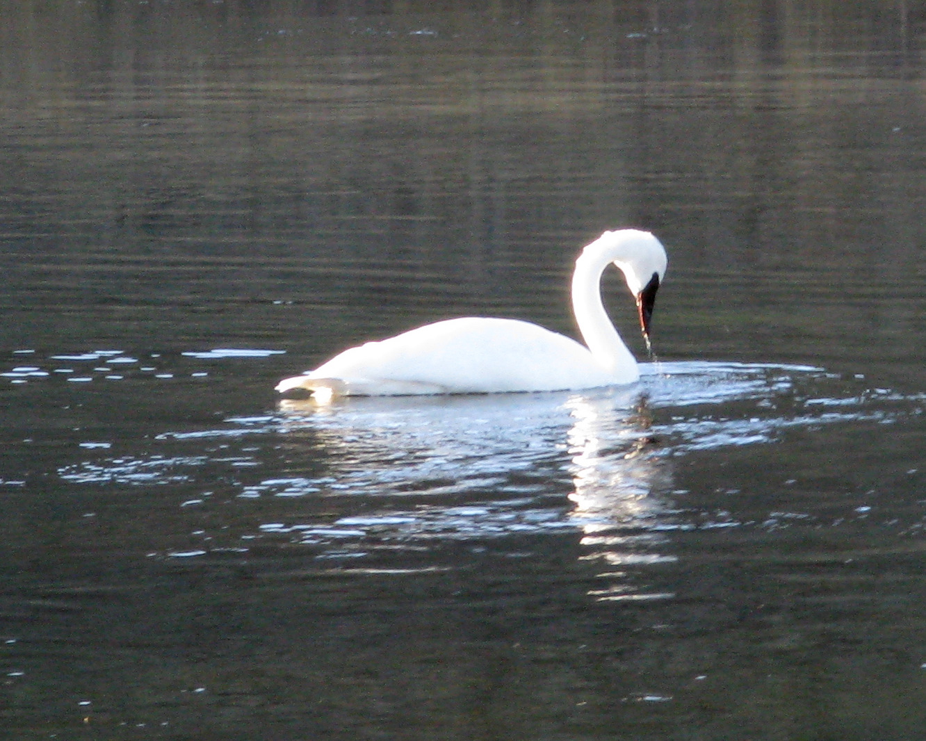
Late that evening, we came across a lone trumpeter swan in the Madison River:
Thursday, October 14: We spotted an eagle in a tree near the Madison, on our way toward Yellowstone Falls:

We hiked to the base of the lower falls -- I think this is the spot where "Yellowstone" got its name (no kidding):

The mist from the falls, combined with the slanting October sunlight, created an intense rainbow, which was nicely set off against the darker rocks on the canyon wall:

The canyon was vividly streaked with mineral deposits -- hot springs had percolated up through the rock, leaving iron, sulphur, manganese, and copper, and then the river had cut down through the plateau, exposing the sides of the fossilized springs, which then had eroded into brightly-colored wedges:

We then took a back country trail on the south rim of the Grand Canyon of the Yellowstone, through a geothermal area. The earth's crust seemed fragile -- there were mudpots and smoking fumaroles everywhere. (I read that half of the planet's geysers are in Yellowstone. I believe it.)
If you've never heard a mudpot puffing away, click on the video:
Friday, October 15: We took a long drive up to Mammoth Hot Springs, in the northern part of the park. The hot springs were eerie, a wasteland of dead trees and bubbling terraces:


Any object submerged in that mineralized water would quickly become petrified -- just ask this unhappy dragonfly:

Later, we hiked to Boiling River, where a thermal stream meets the Gardner River near Gardiner, Montana -- yes, the two are spelled differently. The hot river is at about 200 degrees and the cold river is at 50. The steam rises from the hot stream as it pours into the cold river:

We changed into our bathing suits and found out that if you get too close to the hot water, it is scalding. Too close to the main stream, and it is too cold. We located the "comfort zone" of 100 degree water and soaked in this natural jacuzzi for about an hour, surrounded by sage brush and cottonwood trees on a cool, breezy day:

On our "commute" back to our campsite, we watched a coyote hunting mice in a meadow:

Later, we ran into a herd of elk fording the Madison River:

The bull stood guard:

Saturday, October 16: On a rainy and cold day, we drove south from the Yellowstone area to the Tetons. All of the campgrounds were closed, as were all of the nearby RV parks and the lodges. Fortunately, boondocking was available in the nearby Gros Ventre National Forest; we ended up (with the ranger's permission) in a closed campground near Lower Slide Lake, just a few miles east of the Grand Teton National Park boundary. The cold wind cleared out the storm in the late afternoon:

This was a wonderful campsite -- silent, isolated, yet accessible via decent gravel road (rather than our usual rocky dirt road). Every night, the wind would howl around the trailer; we could hear coyotes wailing in the distance. Across the lake from us was a very peaceful-looking cattle ranch. Every so often, when the wind stopped, we could hear the cows mooing in the distance.
It was so quiet that one evening, while we were out for a moonlight walk, we heard a flock of Canada geese landing in the middle of the lake. I don’t mean that we could hear them honking, which is no great feat. We could actually hear the simultaneous splash as they all skidded to a stop, half a mile away.
Sunday, October 17: The morning was clear, windy, and very cold; it was in the low 30s inside the trailer. We were dressed, as always, like Siberian peasants:

I know what you are thinking -- "why didn't they run the heater?" When we are boondocking (without electrical power), the propane-powered furnace gobbles a lot of juice from our batteries, and it makes a lot of noise (especially at night) when it kicks on. We do have a generator, but we try not to run it very much, since the whole point of boondocking is to enjoy the silence. So we run the heater when we first get out of bed for a few minutes; we also run it in the evening, when we are getting ready to shower. Other than that, we wear lots of layers, including gloves and jackets, and we spread blankets on our laps during mealtimes. After all, it is camping, right?
Someone asked me what we eat on these Spartan camping trips. Breakfast is almost always scrambled eggs with a four-cheese topping, with toast and butter and fresh-brewed Starbucks coffee, followed by pastry. (No kidding.) Lunch is a peanut butter sandwich and an apple -- easy to carry on a hike. Dinner is usually something brought from home in the freezer, like smoked pulled pork or tri-tip or teriyaki chicken, defrosted and then sauteed in chopped garlic, along with toast and butter and a tossed green salad. We always serve good red wine (often a Zinfandel) -- we drink better wine in the trailer than we do at home. Why not?
Anyway, back to our travelogue: that morning, on our commute to the National Park, we were waylaid by the fall color and the Gros Ventre River:

The views of the Tetons from the Gros Ventre River Ranch were stunning:

It seemed almost as if the Park Service had deliberately placed old barns and cottonwoods in the valley, in order to frame the mountains:

We hiked from the Laurance S. Rockefeller Preserve to Phelps Lake, a pleasant but not very adventurous hike. Late that evening, we could see the Tetons reflected in Slide Lake:

Monday, October 18: Once again, we were detained by the views of the Tetons as we drove from our campsite toward the park. There was a ruined log cabin in a meadow just off the Gros Ventre road:

I climbed inside to shoot the Tetons through a window:

There were quite a few abandoned farmhouses in the Jackson Hole area:

Later that day, we hiked up Signal Mountain, near Jenny Lake. As we hiked down from the peak, we heard this unearthly metallic screeching, sounding something like a rusty gate amplified by a bad speaker system. We quickly figured out that it was a bull elk "bugling" to his herd.
Peering through the trees, we could see the whole herd (with the bull and his huge antlers) grazing in the middle of a lake bed. We tried to tiptoe toward them; they heard us immediately and ran away. After we had come down from the mountain, and as we were driving back to our campsite, we saw a black bear and her cub cross the road.
We could not get enough of the fall color against the mountains, especially in the late afternoon:

That evening, we were treated to another great sunset over “our” lake:

Tuesday, October 19: As we drove from our campsite to the Tetons, the road was blocked by a herd of bison. They refused to move out of the way. Several of them were happily (and comically) scratching themselves against convenient fence posts and roadside snow plow guide poles:


If you've never seen a bison chewing, click on the video:
We took a strenuous hike up Cascade Canyon, with a substantial elevation gain. Once we had made the initial steep climb, the floor of the canyon was surprisingly flat -- clearly a glacial “hanging valley.” From time to time, the stream widened out into little lakes, reflecting the skyline:

As we got further up toward Mt. Owen, we could see the wind gusts blowing snow from the peak:

Right near the trail, a huge bull moose was calmly stretched out in the bushes, chewing his lunch. The reddish bushes are huckleberries, which are very much like blueberries. But the berries are long gone, and the moose is eating the twigs and leaves:

Not far away, we came upon a mother moose and her calf:

The sun sinking behind the mountains provided us with a constantly-changing light show -- these are technically called “crepuscular rays:”

That afternoon, as we drove back to the campsite from the Tetons, the mountains were framed by cottonwoods:

As we approached our campsite, another bull moose crossed the road right in front of us and started munching on a small tree:

It took him a little while to react to us:

Here is a quick video of how he strips leaves from small trees:
Wednesday, October 20: The sunrise was reflected off the mountains:

On our way from the campsite to the Tetons in the morning, a herd of pronghorn antelope trotted near to the road. One brave creature came really close to us:

He obligingly looked up when we asked him to, as you can see in this video:
He then trotted alongside the car -- click on the video to watch a pronghorn in low gear:
Our hike on this day was into Garnet Canyon, a very strenuous hike (more than 8 miles round-trip, with about 2500 feet of elevation gain). It was exhilarating to hike into the rocky heart of the Tetons -- Felice is in the lower right hand corner of this picture:

We got way up to tree line at the 9000 foot level:

That evening, I tried some photography by moonlight, with long exposures. The picture of the trailer came out fairly well; if you look carefully, you can see stars above the ridgeline. (This photo may be worth a click.)

This is the same shot, edited three years later in Lightroom:

This 90-second exposure of the Tetons was a little blurred, probably because the wind was howling through the tripod. It was so cold that I had some difficulty with the camera batteries. It's amazing that the colors of the hills and the mountains are visible, even by moonlight:

(Someone asked me how we get these long exposures. I have an electronic cable release -- I open the shutter by pushing a button, count to 90 or whatever, and then close the shutter. It involves a lot of trial and error, which is really fun in sub-freezing temperatures and high winds.)
Thursday, October 21: Sadly, we had to leave the Tetons -- a big snowstorm was on the way. We jogged in the morning along a bike path right next to the mountains and then drove south through rural Wyoming down to Park City, Utah, for an overnight stop.
Friday, October 22: On a rainy day, we drove from Park City to Moab. Again, we considered boondocking, but we wanted to go to Arches National Park, and there was no really good boondocking nearby. We stayed at a nice RV park, just a couple of miles from Arches. The Colorado River was right nearby, flowing through a canyon of red cliffs:

Saturday, October 23: We hiked in Arches NP to Delicate Arch. Although there were a fair number of people on the trail, the hike was really worthwhile. The light kept changing, and our perspective on the arch kept shifting as we clambered around it and through it:


In the afternoon, we hiked in the Windows area of Arches -- this is Turret Arch, with a stormy sky behind Felice. I think this is my favorite picture of the entire trip -- it may be worth a click:

This is the same shot, edited three years later in Lightroom -- much more "true to life:"

This is the other side of the same arch:

A brief rain shower put a shine on the red rock:

We trotted around to the east side of the rock wall, hoping for a rainbow (since the sun was in the southwest), and there it was:

At the end of the day, we walked through Park Place, a dramatic canyon of “fin walls,” the thin vertical remnants of larger formations. On the floor of the canyon, the water had sliced through marbled layers of sandstone -- each layer in this close-up is less than an inch thick:

Sunday, October 24: We hiked in Arches NP in the Devil's Garden area . The La Sal Mountains to the south had received a fresh coat of snow:

At times, the trail was pretty tricky; it followed the top of one of the “fin walls,” which meant that we had to walk carefully on a narrow ridge of sandstone (aka “slickrock”), with a drop on either side of a hundred feet or so:

Felice was able to overcome her vertigo, but we passed several people who could not go on. Double “O” Arch was at the far end of the trail:

Later that afternoon, the fin walls looked like Stonehenge:

Monday, October 25: On a blustery and rainy day (with some snow flurries in the mountain passes), we drove from Moab to Goosenecks State Park in the far southeastern corner of Utah. This primitive park is on the San Juan River, which meanders within steep canyons incised into the plateau. Our campsite was about a half-mile east of the small "park," which had almost no facilities. We were camped, all alone, on the edge of the canyon. Monument Valley is visible to the south, on the right side of the picture:

To our north were the 1500 foot cliffs of Muley Point:

The wind battered the trailer all night long. It was strange being in such a windy place without any trees -- usually, the wind rustles the leaves and sometimes roars or howls in the treetops. But southern Utah is pretty barren -- just low bushes and rocks. There was no roaring, and there was nothing to break the impact of the wind gusts.
Tuesday, October 26: We watched the sun come up and illuminate the canyons and Monument Valley:

Incidentally, "watching the sun come up" is not as rigorous as it sounds at this time of year and in this place. There is nothing obscuring the horizon, and the sun rises at about 7:30 during October in Utah, a very civilized hour.
We drove to the nearby Valley of the Gods, which is a primitive area maintained by the Bureau of Land Management. Unlike Monument Valley (which is tightly controlled by the Navajo tribe), we were able to hike freely among the rock formations. There were no trails, but we climbed up a dry wash to "Lady in the Tub:”

At the very top, we spotted a small cold rattlesnake, apparently asleep in his hole, all curled up. As we got ready to take his picture, he woke up and shook his rattle at us rather convincingly. We put the camera down and backed away slowly as he slithered deeper into his hole.
We drove the “Moki Dugway” up to Muley Point -- this road switchbacked up very steeply, with gravel hairpin turns and thousand foot cliffs on the side of the road. It sounds worse than it was -- we took it slowly, and it was no problem. Monument Valley was easily visible from Muley Point, at about 6200 feet:

This was “big sky” country, even though we were not in Montana. The horizons were endless; the air was ultra-clear. We could see mountains almost 200 miles away. (For example, we could see Humphrey’s Peak, near Flagstaff.) That evening, the sunset over the canyons was astonishing:

Wednesday, October 27: We left the Goosenecks and drove south through Monument Valley, not sure of where to go next -- Flagstaff? Sedona? Grand Canyon? We decided that this was the perfect season for the south rim -- not too crowded, cool and clear, and it was right on the way home. (We are still getting used to the idea of spontaneous travel -- it seems so strange and risky.) We decided to stay in the RV park near the rim, because the boondocking would have been 10 miles away. Late that afternoon, we had time for a hike along the rim:

This is the same shot, edited more than five years later in Lightroom -- this is much more realistic:

There was a bright ice rainbow (sometimes called a "sun dog") near the sun:

We watched the sunset from Hopi Point:

The reflection of the sunset bounced around inside the canyon:

Felice forced me to hike back along the rim after sunset in the dark, which was actually very pleasant. Late that evening, after dinner, we again went to the rim to watch the moon rise. It was bitterly cold, with a very strong wind, gusting up to 30 or 40 mph. In this time exposure, you can see the moon rising, a few stars, and the surrounding trees blurred by the wind gusts:

Thursday, October 28: Nine weeks to the day after Felice's surgery, we took a very ambitious hike down the South Kaibab Trail to Skeleton Point. The round-trip distance was about 6 miles, with an elevation loss (and gain) of over 2000 feet. It was strange to be within the canyon, rather than looking down on it from the top. (Felice is holding up nine fingers.)

We got down far enough to see the river. (Maybe someday, we will hike down to Phantom Ranch, spend the night, and hike back up the next day. I think we could do it!) That evening, we watched perhaps the best sunset of the whole trip, which is quite a strong statement; given the wide open horizons and the clear skies, we watched the sunset almost every night:


Friday, October 29: In the morning, Felice forced me to jog on the rim trail; with an elevation of 7000 feet, the jog was fairly strenuous (but was actually kind of fun):

We started driving west, not knowing exactly where we would stop: Kingman? Needles? Barstow? Much to our surprise, we drove all the way home, almost exactly 500 miles, the longest drive we've ever made with the trailer. It took us 10 1/2 hours, door-to-door. No problem!
And now, as promised, the banana story: when we bought the bananas in Idaho Falls, they were green, but we figured that they would ripen. Three days later, they hadn't changed color at all, and we realized that the trailer was so cold that these bananas might last forever -- sort of like taking a vacation in the cold produce room at Costco. Here, then, is the photographic record of their eventual fate:


11 comments:
Wow...such beauty....loved the banana story...love, Kim
Thank you so much for this wonderful trip report. We were in Yellowstone and Grand Tetons back in August and you have awoken in us a desire to go back later in the year (maybe next year) and see all the things we missed. I want to soak in that hot water. See Yellowstone again without all the crowds and NO wildlife. I think most of the animals were hiding from the tourists.
You guys are such an inspiration to us all! You are living a lot of our dreams. Thanks for taking us along!
Always love the natural hot springs :). Wonderful pictures, glad my RV's furnace doesn't gobble the power as bad!
Your pics are great. I visited most of these places last summer, however my pics are not as good as yours. i took a trip across the U.S. i was gone for three months and put 15,000 miles on my tow vehicle. Great experience. My blog is:
http://my-travels2010-exboater.blogspot.com
Can't thank you enough for the awesome blog and photos. Rita & I visited many of those places on 2 different trips in '05 (Yellowstone area) and this year (Moab area).
They are wonderful even in the summer but I can appreciate the peace and quiet you found there. Riding our motorcycle around the Teton scenic loop was a lifetime highlight experience. Glad you included a couple shots of the trailer too.
Peace & Love!
KyDan
Dan what do you use to pull your Shadow Cruiser?
I intend to purchase one this coming spring and was wondering if my Ford can do the job.
Data2000 asked about our tow vehicle. It is a 2005 Nissan Pathfinder with a 6000 pound tow rating. That is overkill for our little trailer, but it has very beefy brakes and transmission.
Out standing nature and our favorite,currently in the East coast but will be back.
Thanks for sharing we are doing the Tetons and Yellowstone this spring... hopefully before the big crowds.
I would totally pull the kids out of school for a fall trip and some "real" life experiences.
Thomas
My fiance and I, got engaged in June in Yellowstone. He proposed on a small wooden bridge overlooking the Upper Falls. Being from Jersey, I had never seen anything as naturally beautiful as Yellowstone. He and I loved it so much that we have planned our honeymoon in the Grand Tetons. Your photos have us sooo excited! Thank you
Post a Comment