Every summer, we try to take an ambitious trip (usually in July). This year, we were hoping to go to the high country of Southwest Colorado; but in mid-June, I spoke to a ranger in the area, who said that the trails in the area were covered with 10 feet or more of hardpacked snow. So, a quick change of plans -- almost 2 weeks in coastal northwestern California, followed by almost 2 weeks in the Sierra. This was going to be a "consolation prize" trip; but as it turned out, it was a first-prize winner!
We headed north on July 3 and spent a delightful evening with Kim, Felice's college roommate, who lives in Stockton. On July 4, we arrived in Redcrest, at the north end of Humboldt Redwoods State Park, south of Eureka. The next day we took a lovely (albeit hot) hike in the Rockefeller Grove/Big Trees area, along Bull Creek:

July 6: We decided that biking would be cooler than hiking. We rolled slowly along Mattole Road and Avenue of the Giants, admiring the old growth:


Here's a quick video, so that you can get the feel of rolling through the shady woods:
Strangely, the most interesting parts of the bike ride had to do with people, rather than the trees. At one point, we veered off the main road onto a little dirt road that wandered next to the Eel River. At the end of the dirt road, in the middle of nowhere, we came upon a new white Mercedes coupe, decorated with wedding pom-poms. On the back window, the happy couple had scrawled "Newlyweds Plus Baby." The young mom was leaning against the car, proudly watching her new husband and her toddler as they stood near the stream in their bathing suits, happily tossing pebbles into the water. It was such a lovely scene that we just had to turn away -- because we didn't have the heart to tell them that the dad and the baby were standing in a waist-high patch of poison oak. (Our guess is that the rest of the honeymoon wasn't quite so wonderful.)
Later, we passed by an out-of-the way RV park located right on the river. As we rode our bikes into the park, we noticed that virtually all of the RVs were older motor homes, and most of the campers were old fishermen, sitting around enjoying the afternoon breeze. Out of idle curiosity, we stopped at one motor home to ask a couple of guys how they liked the RV park. One of them started to answer almost incoherently; he'd obviously been drinking. His buddy piped up, "Oh, don't mind him, he's already had a few." The first guy shouted, "Yep, the kids all call me Uncle Drunk, but that's OK, 'cause it's true!!" We decided that this wasn't exactly our kind of RV park, but our little dilapidated trailer would have fit right in.
Still later, we were riding back along the Avenue of the Giants. The afternoon had gotten pretty hot. As we came around a curve, we spotted a rather luxurious Honda three-wheeled motorcycle pulled off to the side of the road; an older, very out-of-shape couple stood next to the motorcycle in the shade. As we approached, we could see that they were each holding something in one hand. We stopped, and we realized that they were munching on honest-to-goodness Twinkies, complete with plastic wrappers. The older lady greeted us: "Howdy! Sure is hot, isn't it? We just had to stop and cool off." I wanted to say, "Yes, and nothing says cool refreshment like a Twinkie." (But I didn't.) It turns out that they were from Bakersfield and were unsuccessfully trying to escape the heat by fleeing to the redwoods.
July 7: We escaped the heat by fleeing to the coast. But first, we took a "dream jog" (Felice's words, obviously) through the forest at Bull Creek -- gotta get some exercise before a long car ride. The road over the mountains to Mattole Campground, a primitive BLM facility, was rough, long, steep, and twisty, but very scenic. The campground was almost deserted; the beach was just behind the trailer, over the dunes:

We hiked along the beach to the estuary of the river -- the wind was blowing so hard that the sand was exfoliating our legs. Later that afternoon, we took an exciting ride in the Canyonero (our SUV) up a very steep dirt road (hurrah for four wheel drive!) to a bluff overlooking Cape Mendocino. The wind was blowing at 40 mph; the campground is hidden under the bluff at the left side of the pictures:


We were sure that the fog would come in every afternoon, the way it does at home during the summer in coastal Orange County -- but amazingly, the skies were clear, even at night. As you might expect in such a remote and dark location, the stars were astonishingly bright and thick -- we could easily see the ropy texture of the Milky Way.
July 8: We took a series of short bike rides on quiet country roads. The area is not really well-suited to biking because most of it is so steep; and as we discovered, there is very little hiking in the area, other than hiking along the Lost Coast.
July 9: In the morning, we walked along the beach for quite a while toward Punta Arena. Here and there. backpackers had built driftwood shelters to protect themselves from the wind:

The Lost Coast was impressively desolate; it is amazing to find a huge stretch of California coastline that is completely undeveloped:


We hitched up and drove that afternoon to an RV park in Fort Bragg.
July 10: We had heard that there was primitive camping in Jackson Demonstration State Forest, just a few miles inland from Fort Bragg; the state Department of Forestry, which administers the demonstration forests, does not actively promote its camping facilities. Armed with a topo map and my GPS, we went "campground hunting" in the morning, hoping to leave the RV park behind. (Hunting around for "boondocking" or remote camping is always time-consuming, but that is part of the fun. It is very liberating to travel without a set schedule or destination.)
We found the obscure entrance to the state forest; we left the highway and drove down into the forest, over several miles of rough gravel roads. There were campsites along the road, but they were all marked "closed." Very discouraging. After crossing a small stream, we arrived at what appeared to be the "camp host" site, but it was abandoned. There was a large signboard indicating that most of the campsites were unavailable.
At this low point, a young forestry ranger drove up in his Jeep. He greeted us like long-lost friends and told us that there was a perfect campsite just waiting for us down the road and that he would escort us there. We followed him to a dream campsite: far from anyone else, and situated in a shady grove of very large second-growth redwoods. He proceeded to tell us that the campsite had its own outhouse (a luxury!), and that it had bear-proof trash cans. He told us that during the week, a "senior citizen retired annuitant" (his words!) would show up to remove the trash.
Best of all, the campsite was a "pull through" -- no backing up necessary. (We've become experts at backing up, but sometimes it's very nice to just drive right to the perfect spot.) We also discovered that our campsite came equipped with its own little stream and waterfall, perfect for our late-afternoon cocktail hour. And, by the way, the campsite was absolutely free -- the Department of Forestry does not charge for camping. Since the area was fairly close to the coast, it was delightfully cool and breezy.
After reserving this amazing site on the signboard, we zipped back to the RV park, packed up the trailer, hitched up, and drove back down into the forest. The trailer looked very small next to the redwoods:

The Department of Forestry allows campers to gather and cut downed wood -- so I whipped out my small bow saw, and Felice and I took turns cutting firewood:

Once we had gotten the trailer all leveled, stabilized, and arranged (which always takes a good bit of time and effort -- part of the fun!), Felice said, "I wonder if there's any decent mountain biking in this area." My topo showed that the little dirt road that led to our campsite followed a stream up into the hills, without gaining too much elevation. So off we went. Just beyond our campsite, we encountered a locked gate, which kept the nonexistent cars from using the road (but did not stop our bikes). This dream road continued for another several miles, alongside the stream; the road surface was covered in a thick carpet of redwood "duff" (leaf litter), cushioning our tires. It was a fantasy bike ride (if your fantasies run toward bike rides):

July 11: Based on a tip we had gotten from another pair of middle-aged mountain bikers, we went riding in the network of fire roads behind Caspar, California, a little ways down the Mendocino coastline. The roads followed the various forks of Caspar Creek; some of them were a little steep. It was shady and pleasant, with ferns and columbines everywhere:

July 12: We hiked through Jug Handle State Natural Reserve. This little park follows a series of wave-cut terraces from the beach back through a mature redwood forest. The trail began on the headlands:

Back in the forest, we came across lots of purple iris and some of the last rhododendron blooms of the season:


The streams were choked with horsetail ferns:

At the highest level of the park, a shallow layer of clay hardpan soil had stunted the roots of the trees, creating a "pygmy forest" -- imagine bonsai trees planted in small impermeable containers. Here, Felice (not a very tall person) is as tall as a fully-grown 100 year old redwood:

We went beyond the back boundary of the state reserve onto an abandoned plant nursery -- most of the plants were dead, but we came upon an astonishing patch of reddish-orange flowers within a fenced enclosure -- I have no idea what these are:

Near one of the abandoned greenhouses, I saw a truck with a faded logo for "John Podesta & Sons Nursery." When we got back home, I looked up the company -- it was defunct. I called the number that the company used to have -- I spoke to a very nice elderly lady,, who I think was Mr. Podesta's widow. She told me that he had passed away in 2006 and that she didn't know anything about the flowers at their former Mendocino site. A mystery.
July 13: We biked through Van Damme State Park on a gloriously windy day. We started out hiking on the headlands -- the color of the water was a deep turquoise:
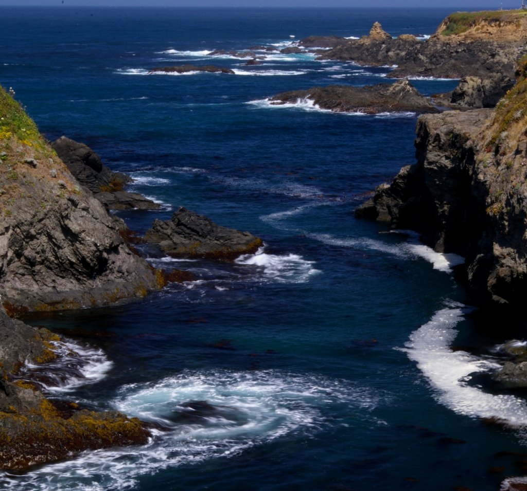

Here's a quick video of the water swirling around the dark rocks:
The headlands were undercut by a few sea caves, some of which had become "sea bridges:"

This is a view toward the south from the headlands -- I used a fairly long exposure to blur the waves:

This short video (taken from a bike!) gives you the feel of riding through Van Damme:
At the end of the day, we enjoyed cocktail hour next to our own private mini-waterfall -- the sun was filtering through the trees and hitting the "falls:"

July 14: We biked through Russian Gulch State Park. Unfortunately, because of the state's budget crisis, the trails had not been maintained, and we had to carry the bikes over several large fallen logs -- quite strenuous. At the end of the bike trail, we parked the bikes and hiked to a lovely waterfall:

Felice wanted to get closer to the water:

She spotted two banana slugs engaged in some sort of a wrestling match -- she described this as yin and yang, but I can't tell who is who:

In case you're interested (and who isn't?), banana slugs are hermaphrodites. If you'd like to learn more about these fascinating creatures, go look them up yourself. I can't say anything more on a G-rated blog.
Later that afternoon, we rode along the Big River bike trail, just south of Mendocino. It was lovely; the trail was shaded and wound in and out near the river. Long ago, the river had been used for transporting redwood logs; in this picture, you can see remnants of an old wharf, on the left bank of the river, next to Felice's left arm:

July 15: We spent most of the day riding around the old logging roads within the Jackson State Forest. Very pleasant bicycling, mostly near streams, but not particularly remarkable. Once in awhile, we encountered logging trucks thundering down these narrow gravel roads. Later in the day, we took a drive up to Chamberlain Falls, also within the forest. The falls were nice, but nothing special. However, they were set within an old-growth grove of redwoods:

We made it back to the campsite in time for cocktails by our little stream -- although the afternoon was very chilly, we bundled up:

July 16: We drove down to the Bay Area and spent the night at Matt's apartment in San Francisco. We were delighted to discover that he has a very modern, well-appointed, and sleek washing machine, which got quite a workout from our bulging bags of recreationally-soiled laundry.
July 17: We spent most of the day walking around San Francisco with Matt and Greg -- I later measured our route on my topo map, and we covered more than 10 very eclectic miles, beginning with a farmer's market:

Late that afternoon, during martini hour, Matt revealed to us that he has been eating moderate quantities of baked (not fried!) pork rinds as a snack:

He argued passionately that they are high-protein, relatively low-fat, and lower in calories than a comparable serving of potato chips. (Remember, he's practically a doctor already, and he seems to know what he's talking about.) After a few deep breaths, we tried some, and we are ashamed to say that they were absolutely wonderful.
July 18: We drove from the Bay Area to the Berkeley-Tuolumne Camp, which is very close to the entrance to Yosemite on Highway 120. On the way, we spotted a patch of ripe sweet blackberries in the San Joaquin Valley and picked several containers full. Since this was the 37th anniversary of our first date (on July 18, 1974), Felice decided to celebrate by purchasing a half gallon of French vanilla ice cream. We found a nearby picnic table:


We pulled into Tuolumne late in the day, hoping to surprise Shelley for her 50th birthday. Rona, who was in on the gag, persuaded Shelley to come to Rona's tent to "check out her new tarp." Felice and I were hiding under the tarp:

Shelley then mentioned that she had just been thinking about us, since it was cocktail hour and she didn't have any of the fixins; whereupon I reached into my backpack and pulled out my trusty gin, tonic, and lime:

July 19 and 20: These were two typical camp days -- very relaxing, and not much happened. On the 19th, we hiked to Small Falls. The river was flowing very vigorously; it was a little intimidating. All of us swam across the stream to get up near the falls; Mollie bravely mastered her fears and joined the crowd:

Felice, Shelley, and Rona enjoyed tie-dye in the cool shade of the arts and crafts workshop:

Later, we all adjourned to the beach to enjoy cocktails:


July 21: We drove over Tioga Pass and headed north on Highway 395 to Obsidian Campground, a primitive facility in the Humboldt-Toiyabe National Forest. It's located north of Bridgeport at around 8000 feet, at the end of a long rough gravel road. Although a lovely creek runs past the campground, there is no drinking water, which tends to hold down the crowds. (We hauled in 60 gallons, enough for a week or so.) The campsites are widely spaced and shaded by aspens and Jeffrey pines. Very quiet and peaceful -- just the sound of the wind in the trees and the water tumbling over the boulders in the creek.
Photos can't capture the unique magic of remote-country trailer camping -- the silent, cool, dark nights, the long relaxed breakfasts of eggs. toast, Starbucks coffee, and Danish pastry, the leisurely dinners accompanied by better-than-our-usual red wine. Yes, it is a lot of effort to prepare for these trips and to set up camp, but these trips are priceless.
July 22: We hiked up the Burt Canyon Trail, which takes off into the Eastern Sierra near the campground. We saw quite a bit of evidence of beaver activity:


The Indian Paintbrush was in full bloom:

This picture, taken just above the campground, gives you a taste of the wide-open high country north of Bridgeport -- the whole area has a very "Wild West" feel:

July 23: We hiked up toward Green Lake. Unfortunately, the trail is shared by hikers and horses. The hikers are mostly housebroken, but the horses aren't. The lake was surrounded by snowy peaks:

We wanted to get up to East Lake, but the outlet stream was flowing so furiously that we couldn't cross it safely. In the meadows, we saw quite a few of these flowers -- they are sort of like leopard lilies, but not quite:


July 24: We hiked the length of Lundy Canyon. We saw some of the biggest aspens we'd ever seen -- Felice (an inveterate tree-hugger) could not come close to getting her arms around them:

These intricate purple things grew in marshy areas -- we had never seen them before:

Among the dry rocks at higher elevations, we saw these little bell-shaped flowers:

Just as in Burt Canyon, we saw lot of beaver activity, but no beavers:

This is a beaver lodge:

All along the hike, the aspens shook in the breeze, providing us with both shade and sound:
Toward the top of the canyon, we spent a lot of time clambering around near the cascades:


At the very top of the canyon, we stepped carefully across a loose talus slope and then inched out onto a narrow ledge. We peered up at the waterfall thundering down from Helen Lake in the 20 Lakes basin area of Yosemite, far above us:
Late that afternoon, returning up the dirt road to our campsite, we got a great perspective on the valley of the Little Walker River; the campground is located in the patch of shadow at the left-center of the picture:

July 25: We decided to shift our campsite south, to take advantage of the great hiking in the Bishop Creek area. We scored a prime campsite at Sabrina Campground -- you can see the snowy peaks under the awning behind Felice:

Late that afternoon, we took a short hike near South Lake:

July 26: On a wonderfully cool and breezy day, we hiked up toward Bishop Pass, starting at South Lake, passing Long Lake, Spearhead Lake, and Timberline Tarns, and ending at Bishop Lake. This was a long and strenuous hike of almost 9 miles, starting at 9800 feet and ending at around 11,200 feet. The rocks along the trail showed unmistakable evidence of glacial scouring -- small rocks trapped in the glacial ice had scratched this large boulder, clearly showing the direction of the flow:

The views at Long Lake were literally breathtaking (perhaps in part because of the altitude):

This is a brief video panorama of the lake:
Along the arduous (but lovely) trail, the flowers kept us entertained whenever the trees blocked the view. These are Jeffrey's Shooting Stars:

These are leopard lilies:

And this is some sort of wild garlic or onion -- when the foliage or the flower is crushed, it gives off a mouthwatering aroma:

Some of the stream crossings were a little tricky -- many of the stepping stones were underwater. We ended up adding rocks to this crossing to make it easier. Thank goodness for our hiking poles -- very helpful when we were trying to balance on the rocks::

Up at Timberline Tarns, the snow banks were still ten feet high, casting deep blue shadows on the water:

The stream flowed into the tarns under a thick snow bridge:
Finally, we made it through the snow, above treeline, up to barren Bishop Lake, which required one of those ever-popular "boot shots:"

2 comments:
I remember Mattole Beach, I made the mistake of driving there from Ferndale vs through Humboldt.
The end of the road from Humboldt is very tame by comparison to the Ferndale/Pertollia end of the road.
Thank you for the great pictures and sharing your adventures.
Post a Comment