(Remember that you can click on the photos to see a
slideshow, and then hit "escape" to get back to the text. Also, a
note on the photo credits: as always, both Felice and I took these shots, and
many of my shots resulted from her suggestions.
I do the photo editing using Lightroom; my goal is to reproduce just
what we saw, as faithfully as possible.)
Sept. 22: We drove from Twin Falls to Great Basin, less
than 350 miles. It rained on and off all
the way, but it was still an easy and pleasant drive. The road (Highway 93) was absolutely empty,
the road drainage was fine, and it was not hot!
Northeastern Nevada is a hilly desert, not as bleak as the area around Las
Vegas. We passed the time listening to
podcasts that Felice had downloaded at home – very enjoyable.
As with most
of the territory we saw during this whole month, this was “double scan”
country: turn on the radio, hit the
“scan” button, and nothing comes up, neither on the AM nor the FM bands. Just static.
That is wonderful, as far as I am concerned – it’s a sign that we are
really out in the boonies. The only
problem is that we were completely out of touch with the news during the height
of election season. (On the other hand,
not such a problem at all, especially this year.)
We got to
Great Basin in the mid-afternoon in a rainstorm and snagged a campsite at Lower
Lehman Campground (or so we thought).
After unhitching and paying, we drove to the nearby Lehman Cave Visitor
Center to ask a few questions, and we spotted this great rainbow over Baker,
Nevada, to the east of us:

But when we
got back to our campsite, there was some unfortunate guy in a beat-up old van
parked in front of our trailer. He told
us that this was his campsite! It turns
out that he was so broke that when he had taken the campsite and had later left for the day, he had nothing in his van that he could have left on the pad to show that the site was taken, which is the
universal practice – not even a chair or a bucket. He had attached a little paper tag to the
clip on the campsite pole, but the rain had plastered it to the pole and it was
not visible. Moral of the story: even if a campsite looks vacant, check the clip to see if there is a current tag.
So we
re-hitched and drove over to the Baker Creek Campground and got the last open
trailer-friendly site. We were surprised
that all of the campgrounds had filled up on a rainy Thursday in late September;
this could have been a problem, since all of the campgrounds are first-come,
first-served at this time of year, and we would have had to go elsewhere. As it turned out, we really liked our
campsite – we could hear the stream, the campground was very quiet, and there
were four wild turkeys who paraded comically back and forth through the bushes, a mother with three
chicks. (We later figured out that they were gorging on pine nuts -- pre-stuffed turkeys! Just add sage . . . . )
Sept. 23: It had rained on and off during the night,
and we could see snow in the higher elevations.
Let’s go! So we took the Wheeler
Peak Road all the way up to the trailhead at 10,000 feet, hoping to get to the
Bristlecone trees, the oldest living things on Earth, and then up to the only
glacier in Nevada. (5 miles and 1100
feet of gain.)
On the way to
the trailhead, we stopped off at Mather Overlook:

Right at the
trailhead, there were snowy bare aspens next to trees still full of color:

There was fresh snow on the trail to the Bristlecones:

According to
the plaque, this tree (still living) is 3200 years old – that kind of perseverance deserves a
picture:

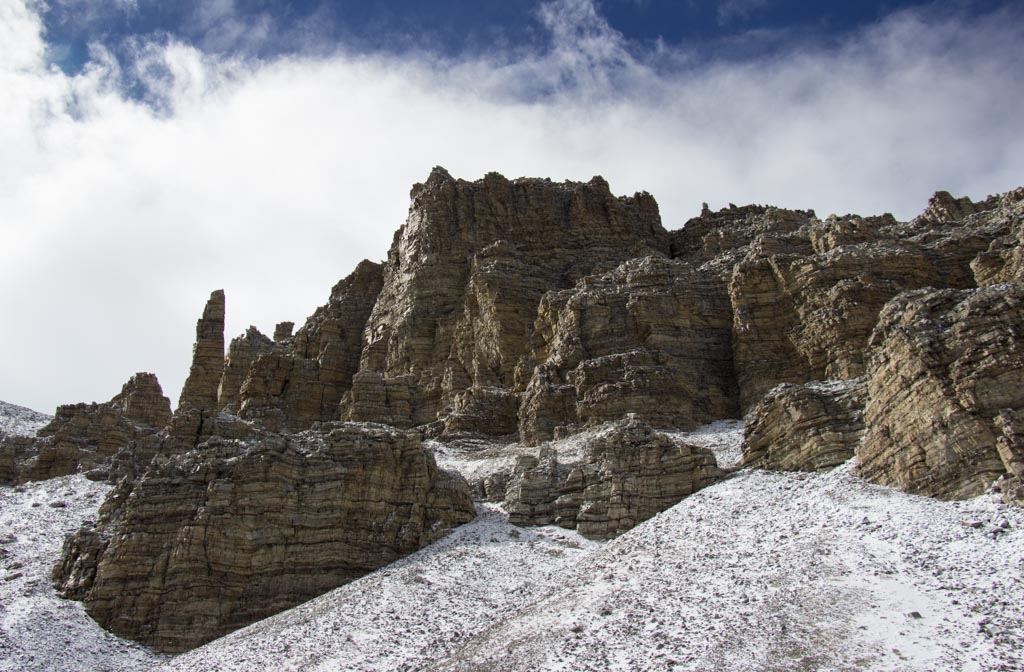
The snowy, gnarled
Bristlecones were silhouetted against the storm clouds:


These pictures
make the hike look more adventurous, difficult, and cold than it was. The temperature was in the high 20s,
perfectly comfortable for hiking. It was
windy and sometimes a little foggy, but not too bad at all. The snow was only about six inches deep. And we were wearing our snow gaiters, which
are knee-length and waterproof.
In this next shot,
Felice is in the lower left corner. The hilly stuff in the middle of the picture is a rock glacier:

Apparently, the rock is thickly laced with
ice that thaws and freezes. As it
re-freezes, the ice between the rocks expands, pushing the pile of rocks slowly
downhill. The trail took us up onto the
rock glacier, fairly close to the headwall, over some pretty blocky talus. The drifted snow on the trail actually made
the hiking easier because it filled in some of the rougher patches.
As we were
getting ready to turn around, the sun came out for a moment and illuminated the
stratified rock:
Sept. 24: We took the Timber Creek Loop, 5 miles and
1700 feet of gain. Most of the route up was very steep, but at least the surface was good.
There were plenty of old aspens along the trail:


There was more
fall color on the trip back down:


The trail down
was right along the creek, with many small cascades – very shady and pleasant.
That
afternoon, we drove up the Wheeler Peak road to the 8500 foot level, where we
had spotted a dense grove of piñon trees. We had been told that the pine
nuts were in season and that there were two ways to harvest them: directly from the cones, or else from the
ground where they had fallen from the tree.
Frankly, we
were skeptical – if the pine nuts were any good, how could there be any left on
the ground? Wouldn’t the squirrels eat
them all? It turns out that there were
so many pine nuts under the trees – thousands under each one – that the
squirrels were probably sick of eating them.
We were also
told that the cones were full of sticky sap – as this photo clearly shows. That white junk on the tips of the cone
segments is like glue:

Each of those
nutshells is around 3/4 of an inch long -- maybe a little less. The
nut inside is about a half-inch long and a quarter-inch wide. We decided not to touch those cones and opted
for the “just pick them up from the ground” strategy.
To protect our
hands from the sap that had dripped from the cones onto the ground, we wore
disposable nitrile gloves – the ones we usually use when dumping the black and
gray water. (News flash: gathering pine nuts is more fun.) We also brought a small step-stool, so that we wouldn't have to kneel or squat -- too hard on the knees!

In much less
than an hour, we had gathered two decent-sized plastic bags full of pine nuts,
while working in the pine-scented shade on a mountainside at 8500 feet. If you have to do stoop labor, this is the place to do it:

When we got
back home, we discovered that they were easy to prepare – rinse them, soak them
in salty water for a few hours, drain, and roast at 325 degrees for 20 minutes. They're done when the nuts turn a butterscotch color -- frequent testing is required. Delicious!
But kind of a lot of work to eat – you have to crack each shell with
your teeth (gently) and extract the nut.
A little time-consuming, but in a good way.
That night, we
again indulged my Milky Way obsession, since we were in a place that is known
for its “primeval” dark skies, to quote the Park Service publication. We drove up to the Mather Overlook at around
9000 feet (cold and breezy, of course), and this was the result:

(That picture might be worth clicking on.) If you look closely, you can see that the mountainsides are faintly illuminated: the stars were so brilliant that they were dimly reflected by the fresh snow on the north face of Wheeler Peak.
This is a similar shot, oriented horizontally -- I have re-worked it in Lightroom to bring out more of the snow:

Sept. 25: We attempted the Wheeler Peak Trail, actually covering about 7 miles with 2000 feet of gain. At the trailhead, there were great views of the sheer canyon below the peak:

The first part
of the trail was pretty flat and smooth, winding around the base of the
mountain. After a few miles, though, the
trail ascended through the talus on the north slope. At the 11,000 foot level, we ran into a lot of snow and ice. The views
were astounding – we could see for well over a hundred miles in every
direction. When we got up toward 12,000
feet, the wind started to howl over the ridge, making it really hard to stand:

In this brief video, I am actually leaning into the wind at about a 45 degree angle, and the pressure of the wind is supporting me -- fun!!
But in a few minutes, it
got significantly worse – we could no longer stand up safely, even in a deep
crouch. We had to sit down. The wind was so loud that we could not hear
each other shouting. Sticking a hand up
felt exactly like putting a hand out of the window of a car on the
freeway. Bits of ice were sandblasting
our faces.
Basing my
opinion on some Internet research and a series of videos shot at the Mt.
Washington Observatory in New Hampshire (where they have a wind gauge and they showed
the effects of wind on humans at varying speeds), I am fairly sure that the
wind was gusting between 70 and 80 mph. Especially
with all of the ice and snow, it was no longer safe to keep climbing, so we had
to head down. Fun is fun, but there is a
limit to adventure.
On the way
back to the trailhead, we stopped to admire the 13,000 foot peak:


This multicolored aspen was right along the road on the way back down to the campground -- all of those colors are on one tree:

Later that afternoon, we stopped in at the Lehman Visitor Center to see if they had a wind gauge on the peak (no), and then we noticed a fruit orchard just east of the parking area. The trees looked ancient, and they are – we later found out that this was the Lehman Orchard, planted over a hundred years ago by an early settler, the discoverer of Lehman Cave. (I think his name was Lehman.)
One of the
apricot trees still had ripe fruit on the branches – little reddish-orange
apricots, and some of them were pretty good!


Overall, Great Basin substantially exceeded our expectations. It is such a cool and green anomaly, set in the middle of the high desert. There aren't very many hiking trails available, but this park is certainly worth a stay of three or four nights. And it would make a great stopover on a trip from California to Utah or Colorado.
Part V: Eastern Sierra
2 comments:
We have so wanted to visit Great Basin National Park in the autumn for fall color and now you have taken us there! It looks like you two had a grand adventure up in the sky island. How wonderful!
We did the Lehman cave tour on our way through (video on our channel). You guys must have been pack mules in a previous life :-) You really get around ! That ancient Bristlecone is truly remarkable. Hard to fathom what it was like there 1200 years before Christ.
Post a Comment