(Note -- Google has changed the navigation somewhat. If you click on a picture, you will get a slideshow, which is not a bad thing. To get out of the slideshow and back to the text, hit "escape," rather than "back.")
"And now for something completely different:" instead of going to the mountains and forests, as usual, we headed for Death Valley. We had never been there, and we were hoping to see the Geminid meteor shower on the night of December 13. Death Valley has some of the darkest skies in the country, and there was no moon on that night. So all the stars seemed as though they were lining up, and off we went.
Wednesday, December 12: Since the new truck was at the very end of its "break-in" phase, we took the easier route: Interstate 15 to Baker and then north through Shoshone and Death Valley Junction. That route is a little longer (and less interesting) than the western route through Ridgecrest and Trona, but there are no steep grades.
Late in the afternoon, we arrived at Zabriskie Point, which overlooks a rugged area of deeply eroded lake sediments:

Felice said that the furrowed texture of the rounded, brown hills somehow reminded her of a shar-pei puppy:

A storm was gathering over the mountains, and there was a brilliant rainbow ice cloud:

Our campsite was at Mesquite Springs Campground, in the northern end of the park – very remote and quiet:

The clouds over the Grapevine Mountains reflected the sunset:

Thursday, December 13:
It rained on and off during the night – Death Valley usually gets about an inch of rain a year, and we were there for much of it. Fresh snow had fallen on the Grapevine Range:

Since the morning was showery, we decided not to take a big hike but instead chose to drive the Titus Canyon loop, which begins near Beatty, Nevada. During a fairly heavy rain shower, we first stopped at the ghost town of Rhyolite, home of the famous "bottle house," built of liquor bottles that had been cemented together:


Fortunately, the rain stopped as we reached the turnoff for the canyon road. If it had been raining steadily, we wouldn't have taken this route, because of the risk of flash flooding. The dirt road through the canyon was not too bad – sometimes a little narrow and steep, with lots of switchbacks and occasional patches of mud, sand, and gravel. I would not have been comfortable in a passenger car:

Note the road scratched into the red clay across the canyon, zigzagging up the mountain from left to right:

The road came close to the snow line (around 5000 feet), but there was no snow on the road itself:

At one point, we took a short hike up a tributary slot canyon. The wet gravel on the floor of the slot canyon was multicolored:

On the way down, we passed through the Leadfield ghost town:


The last couple of miles were very narrow -- no big deal, but I had to drive carefully. After we emerged from the narrows, we parked and walked back up the canyon:

The walls of the lower canyon displayed intricate calcite "mosaics." Angular chunks of black rock were surrounded by the white calcite; the canyon walls looked like petroglyphs of birds and insects, but these were actually random shapes:


Friday, December 14:
It rained again during the night -- no meteors! We awoke to a lot of new snow on the surrounding peaks, right near the campground. Despite the cold wind, we were forced out of bed to shoot the sunrise on the Panamint Range:


This is the same shot, re-edited a year later in Lightroom -- this is more accurate:


We decided that this would be a good day to hike Fall Canyon, a slot canyon just north of Titus Canyon. We discovered that although camping at the north end of the park was quite lovely, it's really far (30 miles!) from almost everything else in the park; every day, we spent at least an hour in the car "commuting" to and from our hikes. The campground at Stovepipe Wells is much more centrally located, although it is just a gravel parking lot behind the general store.
As we hiked up the wash toward the mouth of Fall Canyon, we looked across the valley at a typical alluvial fan at the mouth of Marble Canyon. We did not know this at the time, but we would spend a good part of Saturday driving across (and up) this same fan:

This is something of a "trick shot" of Felice silhouetted against the wall of the canyon; I took this picture from ground level, and the canyon walls are actually several hundred feet high:

At various points in the canyon, the walls narrowed to a few feet:
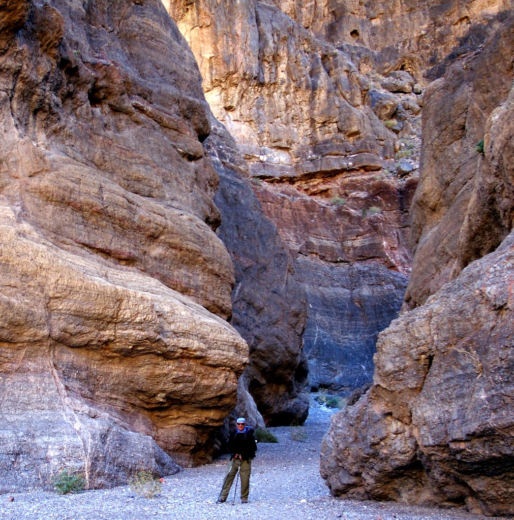

(In the preceding shot, Felice is at the very bottom of the gorge.)

The mountains around Death Valley are sedimentary and metamorphic rock, unlike the familiar granite of the Sierra. And the sedimentary layers have undergone some serious warping:

At the upper end of the canyon, there is a "waterfall" (which really is a waterfall, but only for a few days each year). The smooth, cold marble walls of the canyon had a distinctly bluish tint:

The entire hike was only six miles, but the footing was difficult, especially on the way up -- the gravel was so loose that we would slide back a little with every step. Late that afternoon, we had a little extra time, so we headed north to Ubehebe Crater, which was created by an underground steam explosion. The crater was not far from our campground. We got there not long before sunset, and the colors of the layers within the crater were very vivid:

We hiked around the big crater to neighboring Little Hebe crater:

From the rim of the crater, we could see the rippled layers of ash:

As we continued to climb, we could see that there were volcanic craters and cones throughout the northern end of the valley, silhouetted against yet another evening snowstorm:

This clip provides a panorama of the crater complex:
Saturday, December 15:
After another cold and rainy night, the morning was clear, so we decided to try the Marble Canyon hike. (In case anyone is wondering, camping in our trailer on a cold, rainy night is extremely pleasant – the trailer is very well insulated, and we have a heater, even though we hardly ever use it, except when showering.) The road to Marble Canyon begins at Stovepipe Wells. The first 8 miles or so are through deep sand and dust, and that's the easy part.
The road then drops down into a wash cut into the alluvial fan and then heads up into the hills. I use the word "road" loosely. There is no road, since it washes out every time the canyon floods, several times a year. There are occasional cairns (little rock piles) on the sides of the wash for guidance, but they aren't much help. I put the truck into “four wheel low” (the most extreme setting) and crawled along at about 10 mph. The route travels for several miles over very large rocks; I had to steer carefully around the rocks, so as not to damage the undercarriage or (worse yet) so as not to get stuck on top of a rock, many miles away from a tow truck.
I am sure that a really experienced off-road driver would not be impressed by the Marble Canyon drive, but it was a big deal for a newbie. This was our first real off-road trip with the truck (the Canyonero? the “sensible truck?” – we still are not sure what to call it). It performed beautifully. I drove slowly but steadily through the deep sandy patches – much dust was kicked up, but the tires did not sink in. The tires are sort of hybrids – not really aggressive off-road “all terrain” tires, but not ordinary street tires, either. And in the rocky patches, the truck stepped over the big rocks with no trouble at all, due to the special off-road suspension. I got a few minor scratches on the sides from the spiky mesquite bushes growing in the wash, but that is the price of off-roading. I know that it is not politically correct to say so, but I have to admit that the drive was really fun:

Felice took some video of the drive – unfortunately, the camera had switched itself to “low resolution” mode, so the image quality is not perfect. On the other hand, the grainy quality complements the rough ride:
We were amazed that the National Park Service allows off-roading in Death Valley – usually, the NPS is very restrictive about any sort of damage to the landscape. We took it easy, in order to minimize the impact, but this was very different from (e.g.) Yosemite, where hikers are often forbidden to leave the trail for fear of damaging the environment.
Eventually, after about an hour, the “road” ended at the trailhead, and we continued up the canyon on foot. Notice the huge wall of layered rock in this picture – there is a sharp fault running from the upper right to the lower left, and the strata are offset. To provide a sense of scale, I am standing in the lower right corner:

After about a mile of hiking along the gravel wash, we came to a massive monolithic “choke stone” blocking the streambed:

Fortunately, there was a way to scramble up the hill, around the blockage. On the other side, the canyon soon narrowed, with smoothly sculpted marble walls:


The slot trapped the sunlight, bouncing it off of the walls. We could tell that during flash floods, the water scours and polishes the rock, apparently to a height of 50 feet or more:


Late in the afternoon, we still had time to drive back to Mosaic Canyon, near Stovepipe Wells. The lower part of the canyon is an interesting mix of dolomite (a type of marble), overlain by breccia, which is fine-grained sediment surrounding sharp broken rock. Some breccia is volcanic, but geologists speculate that this particular breccia is the result of debris flows that gush down the canyon. The sand and clay cement the shattered fragments of harder rock:

In this next shot, the breccia engulfs the striped dolomite (which is itself composed of limestone that has been altered by heat and pressure to form marble). Note the "shark fin" shape of the dolomite – this is the result of erosion that had sculpted the marble, prior to the flood of breccia:

The dolomite was really the star of the show at Mosaic Canyon – the flowing water had carved it into draperies, exactly like classical sculpture. We dumped a little water on to the marble, just to accentuate the banding and the texture:

As we emerged from the canyon, the sunset illuminated the Grapevine Range:

Sunday, December 16:
As we got ready to leave, we noticed that we could actually see the south rim of Ubehebe Crater, just a few miles northwest of our campsite -- Felice is pointing to the rim:

The drive home was pleasant and uneventful – we headed west from Stovepipe Wells over Towne Pass, which was long and steep but not too difficult. We then went south through the Panamint Valley to Trona and then over to Highway 395. Panamint Valley was very “western” -- austere, utterly deserted, surrounded by snowy peaks. Someday, when we go back to Death Valley, we will probably take the western route.
8 comments:
Very nice-thank you for sharing.
It is on our bucket list.
Dan, great trip report, as always. You are right about the steep grade on the alternate route. Looks like your new tow vehicle is very similar to ours (2005 Tacoma Double Cab TRD OffRoad) and we also tow an X139. We went into and out of Death Valley a few years ago via Panamint Springs (395/136/190). The haul out is the steepest grade we have ever towed on. The Tacoma can readily handle the X139 on that grade, but 45 mph is about the max comfortable speed.
Consider a vist to Death Valley some time in late March/early April. If you catch it right, the spring flowers are awesome.
Jay
Mammoth Lakes
Dan we love reading your blogs. As usual the photography is awesome. We also enjoy seeing a few shots of you guys and your little FF trailer.
Thanks again for sharing!
Happy Camping!
KyDan
This is one of the best travel blogs ever. We have a FF 189FDS & found u on the users group.
I know the photographers are GREAT but I'm dying to know what camera you use & what is your biggest telephoto lens?
It looks as if you guys carry a lot of weight. (equipment not body weight...haha)
We carry two cameras -- I carry a Pentax K110, a basic DLSR. And Felice carries a Canon A720. My lens is the stock 18-55 zoom, not a telephoto. Her Canon has both an optical and digital zoom. Instead of a real telephoto, we usually crop the image on Picasa, which enlarges it without too much grain. A real telephoto lens would be better, but it is too heavy and bulky. I also use a polarizing filter and sometimes a neutral density filter.
Excellent pics! Looks like it was a fantastic trip. Happy New Year!
There is so much life in a place so many think of as barren. We could spend several lifetimes exploring Death Valley. We enjoyed your blog and photos. Thanks for letting us tag along.
Post a Comment