This is just a draft. July 2025 Eastern Sierra
Monday, September 15, 2025
Monday, July 01, 2024
Sequoias and Local Mountains: March - June 2024
Continuing my rehab, we took four quick trips: to Giant Forest in March, to the Grant Grove area in April, to Mt. Baldy in May, and to Mt. Pinos in June.
March 12: We stayed at Potwisha Campground and "commuted" to the Wolverton area, near Giant Forest. It was foggy and cold, but we didn't care -- it was great just to be on snowshoes again.


We stopped off at the Big Trees trail to see, well, big trees:

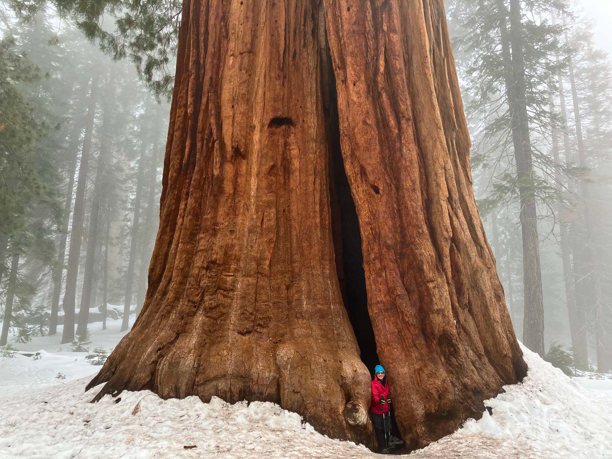


Even though this trail is popular in the summer, we had it all to ourselves --- just add several feet of snow:


The customary wishes were made on the bark of the Sequoias:


March 14: On the way back up the hill, the clouds had lifted, giving us a view of the Great Western Divide:


Back to the Alta Trail for some more silence and solitude:


Sunset at the campground:

March 15: The winter of 2023-2024 had been wonderfully rainy. The Sierra foothills looked like Ireland, only with citrus groves:

As an added bonus, there was a rainbow waiting for us over our driveway:

Note that the sky is darker on one side of the rainbow than the other. This phenomenon is called (no kidding) Alexander's dark band. (Not ragtime.). The explanation involves a lot of physics having to do with the angles at which the light is refracted. It's above my pay grade. As they say, just GTS. ("Google that stuff.")
We had such a good time at Giant Forest in March that we decided to take a quick follow-up trip to the Grant Grove area in April. (Bear in mind that we lost all of 2023 to medical issues, so we have to make up for lost time.)
Azalea Campground is first-come, first-served during the winter. We took a chance and bingo. We snagged a great site located about a hundred yards from any other site, and the snow was not a significant obstacle:

Felice brought some roses from our garden -- why not?

April 10: We mostly tromped around the forest north and east of Grant Grove, just enjoying the freedom of movement that the snowshoes provide. (And enjoying the silence and isolation, too.)


April 11: We started out at the road closure of Generals' Highway and soon found ourselves at Montecito Sequoia Lodge, closed for the season due to the heavy snow and the road closures. Over the past 35 years, we have spent many, many days at the Lodge, both summers and winters.


April 12: Someone had thoughtfully left a sled at our campsite. You might want to crank up the volume to get the full effect for these three short videos:

Apparently, we were not the only ones enjoying Bearskin Grove. These fresh tracks were made by a bear with roughly size 14 claws:

May 15: Our next mini-trip was just a day hike in Ice House Canyon, on Mt. Baldy. The creek was loud and delightful:

Spring!


June 3: Our next mini-trip was to McGill Campground on Mt. Pinos, near Frazier Park. The campground was almost empty. Most of the campsites were very shady; ours wasn't. The campground was at around 7500 feet.
(Warning: a long and exciting story about a DIY fix-it job is approaching. Feel free to skip the next few paragraphs.)
Shortly after we arrived and leveled out the trailer, we noticed that the "check" light was on the refrigerator's display panel. Uh-oh. That would mean that the fridge burner was not getting any propane. I knew the tanks were full. What could be the matter -- was the fridge malfunctioning?
I then tried to light the stove to check the flow of propane. Nothing. With full tanks and no propane flow, the problem was not the fridge. It had to be the regulator, the device that limits the flow of propane from the tanks to the utilities. There was no way I could fix a busted regulator. We were going to have to turn around and go home.
But then I remembered that we happened to have a spare regulator. We'd had a problem about ten years ago with another regulator that made an annoying whining noise, so I got a new quiet one and saved the old noisy one, on the theory that we might need a spare someday.
Well, this was Someday! Time to open the toolboxes.
The hardest part of the fix-it job was finding wrenches to fit the gas fittings on the hoses leading to the regulator. I carry a full set of sockets and open-end wrenches, but some of the fittings were non-standard -- millimetric? Doubtful.
Crescent wrenches did not work either. Fortunately, we had a couple of needle-nose vice-grips pliers, which got the job done. I had a tough time threading the couplings, but Felice's nimble fingers took care of that problem.
We hooked it all up, opened the tank valves, turned on the stove, and lit the burners! Lessons learned: (1) It is still a lot of fun to work together and solve problems, even after 50 years of DIY. (2) Vice-grips pliers are not the first tool I'd reach for, but they are sometimes the last. (3). To the extent possible, carry spares for any mission critical hardware.
(End of DIY detour.)
June 4: We took the Condor Summit trail (which is part of the Vincent Tumamait trail), which starts at about 8800 feet at the top of Mt. Pinos:

The first two miles were in gently rolling terrain. I did some homework and came up empty -- how come the high mountains in this area have relatively flat summits? It must have something to do with the movement of the San Andreas, which runs along the foot of the mountains, but I am stumped.
Speaking of the San Andreas, Felice spotted this anomalous outcropping:

My best guess is that the granite was extruded under water as a form of pillow lava. This is a bold and uneducated guess, but I'm out of my depth. Or it could be just weathered granite, but why would it weather along the seams unless there were layers of different hardnesses? I don't know.
Note, too, that the granite strata (weird phrase!) are sharply inclined, tilted up to a nearly vertical orientation. That is not uncommon for sedimentary or metamorphic rock and is almost certainly caused by uplift due to the nearby San Andreas.
June 5: We took the South Ridge trail, which runs from McGill campground up to Mt. Pinos campground. The trail contoured slowly upward and was very well graded.
The lupine was going strong:


Scent is such a powerful trigger of ancient memories: lupine has a lovely smell, but it always reminds me of the inexpensive laundry soap that my late Aunt Mitzi used in 1955. Long time ago.
Yet another fascinating granite outcropping, with a more typically rounded shape. Note the healthy-looking forest -- have the bark beetles somehow overlooked the mountains south of the Sierra?

June 6: We were having such a pleasant time that we extended our stay for another day, unexpectedly. We hiked around the Chula Vista campground up at the summit and came across the hill where we used to go sledding, back in the early '90s:

No hike is complete without a foot soak:

June 7: We were heading down the hill toward home when Google alerted us to a bad accident on the freeway, with no way around it. What to do? Explore! So we headed out to Cerro Noroeste, a campground at about 8000 feet, just to see what we could see.
It was very pretty, but not worth the long and twisty road up the mountain from Pine Mountain Club. There are very few hiking trails, since the campground sits on a plateau at the summit.
We parked the trailer in the shade -- Felice went for a walk and I took a rest:

Wednesday, January 17, 2024
Anza Borrego Desert State Park: December 2023
December 13, 2023: After a very difficult year filled with medical issues, we finally took a little trip to Anza Borrego Desert State Park to see the Geminid meteor shower. At the beginning of 2023, it looked like our camping days were over – I could not walk.
After back surgery and rehab to deal with nerve damage to my feet, we were once again on the road, testing my ability to deal with the rigors of camping and moderate hiking. (Spoiler alert: no big problems.). We camped in Blair Valley, which has dark skies and plenty of boondocking:


(Those pictures make it look as though we were all alone. We weren't – there were a couple of other trailers scattered about a quarter-mile away.)
Felice took a short hike around the area in the late afternoon and snagged (not literally) this great backlit shot of buckhorn cholla:

The meteor shower was excellent, among the best we have ever seen. There was a little light pollution from distant towns, but not too much. We saw about 25 meteors in about 90 minutes, many of which were bright white or green with long tails. The temperature was around 40 degrees, with almost no wind. I can't say that we were warm, but this was our least uncomfortable Geminid shower, ensconced in our camp chairs, properly dressed, with a big sleeping bag draped over our laps.
December 14: We took the Borrego Palm Canyon trail, which starts in Borrego Springs. Unlike last time, we didn't see any mountain sheep, but the weather was cool and clear.
The boulders lining the floodplain were impressive – imagine the volume of water that tumbled these rocks! To get a sense of scale, Felice is at center right:

More evidence of tremendous flooding – the ends of this massive chunk of palm trunk were rubbed round, like a well-used pencil eraser, after being worn down by many storms:

That huge black boulder deserves a paragraph or two. (If you're not fascinated by rocks, skip this stuff.). Note the color and texture – this is dark fine-grained volcanic rock, almost like obsidian but probably basalt, with veins of quartz, much harder than the coarse-grained surrounding "country rock" of beige granite. How did it get here? Did the granite overlay the older basalt (unlikely) or did the newer lava punch through the granite?
Without scouting far upstream for the original basalt outcropping, there's no way to tell if the basalt predated the granite. But it is clear that this anomalous boulder fell into the canyon and was then tumbled and rounded by thousands of "thousand year" floods. (End of geology moment.)
We came across a "mortero," a cup-like depression in the rock where the native folks used to grind seeds. I am told that the term "Indian" is no longer used:

I am also told that the hard work of grinding the seeds was given to the women, who would sing to keep the rhythm. There are Navajo corn grinding songs available on YouTube – I would guess that the Borrego Springs tribe's songs were similar, but there is no way to know.
After a leisurely climb, we arrived at the palm oasis, complete with a miniature waterfall (about a foot high):


Amazingly, there were little frogs in the pool at the foot of the falls. How did they brave the surrounding desert to arrive at this pool? Tadpoles are notoriously bad hikers. These frogs must be remnants of the ice ages, when the streams ran down into inland seas, providing a way for the frogs to populate the canyons. Now they are stranded on a wet island in the desert. (We didn't get a photo of the frogs, who were unremarkable.)
That evening, as we approached the campsite just after sundown, the almost-new crescent moon was colored by "earthshine," which is exactly what it sounds like: the light of the sun reflects off the earth and illuminates the dark part of the moon. Unfortunately, neither Felice's iPhone nor my old DSLR could quite capture this phenomenon, due to the high contrast between the dark side of the moon and the sliver of "daylight." This is the iPhone shot:

And this is the DSLR shot, with the telephoto zoom:

December 15: The drive home took only four hours. Although the desert is not our top choice for camping and hiking, this little trip was a big success because it proved that we are ready to get back on the road.
Subscribe to:
Posts (Atom)