(Remember that you can click on the photos to see a slideshow, and then hit "escape" to get back to the text. Also, a note on the photo credits: as always, both Felice and I took these shots, and many of my shots resulted from her suggestions. I do the photo editing using Lightroom; my goal is to reproduce just what we saw, as faithfully as possible.)
Since this was a pretty good year for snow in the Northern Sierra, we wanted to see the mountains before the snow had all melted off; it is such a welcome change from the past several dry years. We also wanted to find some really quiet boondocking, away from the hustle and bustle of summer campgrounds. After quite a bit of "flying around" on Google Earth (looking for likely campsites), we ended up in the Eldorado National Forest, west of Pyramid Peak and the Desolation Wilderness.
Since this was a pretty good year for snow in the Northern Sierra, we wanted to see the mountains before the snow had all melted off; it is such a welcome change from the past several dry years. We also wanted to find some really quiet boondocking, away from the hustle and bustle of summer campgrounds. After quite a bit of "flying around" on Google Earth (looking for likely campsites), we ended up in the Eldorado National Forest, west of Pyramid Peak and the Desolation Wilderness.
June 19: Based on our
“flyovers,” we chose an open granite dome at 7,000 feet not far from Wright’s
Lake, instead of a shady spot in the forest, because we wanted to take
advantage of the westerly breeze during the height of mosquito season. (Good call, as it turned out!) Also, an open campsite usually has better
views than a forested site, and this one had views of snowy mountains to the
east and the south.
The paved road from Highway 50 up toward the Wright’s Lake area was very narrow, twisty, and steep: even with the truck floored, we were going under 20 mph. (Admittedly, the trailer held a full load of water, but still, this was quite a road.) And then the secondary forest roads to the west were full of ruts and deep
potholes. No big deal – we just took it
slow and steered around them.
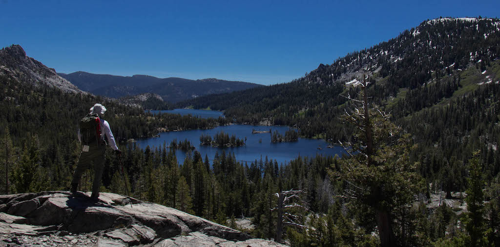
When we arrived at the dome, high above the American River,
we were pleased to find that we had a great view of the Carson Pass area, far to our south – that’s Round
Top on the left side of the picture:

Pyramid Peak and the snowy Desolation Wilderness were to our east -- Felice posed me on a log, since it was Father's Day. (I know it is a non-sequitur, but that's okay.)

There was a wonderful breeze flowing up the canyon -- in order to maximize the airflow inside the trailer, we improvised a prop to hold the window wide open:

After setting up camp, it was time for gin and tonics in the quiet shade of the awning, in the cool, breezy, dry, non-buggy mountain air:

After setting up camp, it was time for gin and tonics in the quiet shade of the awning, in the cool, breezy, dry, non-buggy mountain air:

To be honest, there were mosquitoes (big ones!) during the
dinner hour every night; they clustered on our window screens, clamoring to get in. We toasted them with a good Zinfandel and
closed the windows to silence their whining.
But they were mercifully asleep during the late afternoon cocktail hour, woke up for dinnertime, and then went back to bed shortly after sunset.
This campsite was everything we had hoped it would be –
silent and remote, very relaxing. We
were about 2000 feet above the American River – if we listened carefully, we
could hear it roaring softly in the background, kind of like a faraway freeway (only
much better). We didn't see or hear any
other vehicles near our campsite during the several days that we camped here.
That night, it was chilly (hurrah!), and the full moon lit
up the snowy Crystal Range to the east:

June 20: We decided
to take the Lyons Creek hike, since the trailhead was just a few minutes away
from the campsite. There were masses of
“five spot” near the trailhead – these little flowers (about a half-inch across) grow close to the ground
in big clumps:

The trail was pleasant, but it rarely came very close to the
creek, although we could hear it most of the time. After a few miles, when we got to the point where
the trail crossed the creek, we were unable to get across due to the high
water -- too dangerous. We got fairly close to the high
country, though:

June 21: We drove
over to Echo Lake and took the boat to the upper end of the lake, toward the
Aloha Lake trail. (The boat was kind of expensive, but very worthwhile, saving us a total of five miles of walking.) As soon as the trail
climbed away from the lake, the views of the high country were terrific:

The Echo Lake area stretched out behind us:
The trail to Aloha got pretty tricky. At first, it was really rocky -- like walking on loose baseballs made of granite. Then, when we got up into the high country, the snow became very deep, and at times it was hard
to find the route:

Aloha Lake was surrounded by snowy mountains:


When we got back down to Echo Lake, there was time for a
brief foot-soak before the boat arrived:

June 22: We took the
Twin Lakes hike out of the Wright’s Lake area – the forest service had just
opened the trailhead that morning. The hike
was mostly over open granite slabs, with little shade (but great views of the
mountains):


It is rare to see a cluster of penstemon against a
background of blue sky – usually, this flower huddles low to the ground:

Late that afternoon, before snack time, we found some great
"swimming" in lower Lyons Creek -- very refreshing! (In this case, "swimming" means "splashing
ourselves briefly with ice-cold snowmelt.")
June 23: We decided
to move over to the Carson Pass/Mokelumne Wilderness area, a couple of hours away to the south,
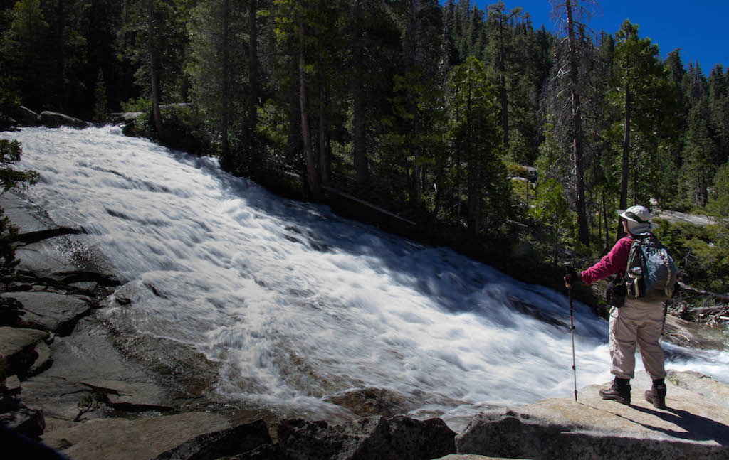
where there was more hiking available. On
the way, we stopped at the Horsetail Falls trail. (By the way, the water at the trailhead faucet is cold and delicious -- we filled three jugs with it.) There is an impressive cascade not too far
from the trailhead:

We were both wearing our new "stout boots,"
leather Asolos with very aggressive traction:

We made it most of the way up to the main falls, carefully
boulder-hopping. We were grateful for
our "stout boots," because quite a bit of the trail involved walking
across steeply-tilted smooth granite slabs.

After the hike, we drove over to the Carson Pass area. After some exploration
in the Toiyabe National Forest just east of the pass, we managed to find
another breezy and open boondocking site, this one at 8000 feet. The forest road leading to the campsite was
incredibly rough, with rocks the size of volleyballs, very deeply eroded ruts,
and potholes the size of bathtubs (one of which was filled with plenty of
water). We put the truck in
four-wheel-drive and crawled carefully around and over the hazards. It was very gratifying that the trailer's
suspension (beefy leaf springs, increased clearance, and heavy duty shock absorbers) was fully
able to cope with this obstacle course, albeit at two or three miles an hour. With enough practice and care, we can now
prudently take the trailer almost anywhere the truck can go, which is very
liberating.
Because we didn't want to crush any of the vegetation (lots of flowers!) surrounding the campsite, we ended up backing the trailer up the hill to a
relatively level pad. It was quite
tricky, but Felice guided me expertly into place. After the hard work of getting the trailer parked, Felice field-tested our shady late afternoon “snacking circle,” with
snowy Elephant’s Back (9500 feet) looming in the background:

That night, before the moon came up, the Milky Way was very
clear, and the whole sky was thickly filled with crisp bright stars:

(As always, I have to confess that these shots of the Milky
Way are a little misleading. Since the
camera takes in a lot of light during a 30 second exposure at an ISO of 3200,
the camera can gather colors that we can’t see in real time.)
June 24: The next
morning was cool and shimmery, with a wonderful breeze. I took this shot in an effort to capture the unique feeling of boondocking, with no neighbors and no pavement, right next door to
the wilderness boundary:

(To be perfectly honest, this campsite wasn't quite as
isolated as the one near the Desolation Wilderness; there was a forest road
that passed nearby, and we did see a few trucks and jeeps each day. But it was still very peaceful.)
Later that morning, we hiked north from Carson Pass into the Meiss Valley along
the Pacific Crest Trail. We were
slightly too early for the height of flower season (which is in mid-July), but
we were not disappointed; if we had come in mid-July, we would have missed the
snow on the mountains. At this time of
year, where some of the snow has melted, the mountains display a "Holstein
pattern" of black and white, which (to us) seemed so much more visually
interesting than either solid white or barren rock:

Notice, by the way, that the rock in the Carson Pass area is volcanic, much darker than the granite in other parts of the Sierra (such as the Desolation Wilderness). Along the trail, there was a lot of neon purple penstemon:

Felice captured me in my typical posture:

When we got to the top of the saddle separating Carson Pass
from the Upper Truckee drainage, we were overcome by irrational exuberance –
fortunately, no one got hurt:

Not to be outdone, Felice decided that she would lift me (or at least
my leg):

The hike was delightfully non-challenging – the surface was
packed dirt, the terrain was fairly level, the scenery was great, and the
weather was cool and breezy. That
afternoon, on the way back to the trailhead, we shot this quick video
panorama. (In the video, I say that this
is the Highway 4 area, but it is really Highway 88. Highway 4 is Ebbetts Pass, not Carson Pass.)
That night, we took some more experimental Milky Way shots –
for this one, I put the tripod and the camera low to the ground, to catch our
silhouettes. We had to hold absolutely
still for 30 seconds, which was harder than it sounds:

A slightly different version of the same shot, re-edited a couple of years later in Lightroom:

June 25: We took a fairly ambitious hike to Round Top Lake, again starting at Carson Pass:


Winnemucca Lake was still partially frozen:

There was still quite a bit of snow on the trail, but it was pretty easy to follow the route. From the saddle near Round Top Lake, we could see the Desolation Wilderness area to the north:

Up at Round Top Lake, the corn lilies were just starting to sprout:

(I know that common corn lillies are not often photographed, but this one was trying hard to look glamorous.)
On the way back, we took a detour to the north side of the
Elephant's Back. The flowers on the
south-facing slopes were just starting to come into bloom:

Late that afternoon, we went to Woods Creek, at the outlet of Woods Lake, to soak our feet -- the water was so cold that our feet immediately cramped up. It was strangely pleasurable, in a painful way.
June 26: Feeling adventurous, we decided to take the Emigrant Lake trail, which starts at the west end of Caples Lake. The first couple of miles were very easy and pleasant, winding along the lakeshore, with plenty of shade. We met some hikers who told us that the trail up to the lake was impassable due to deep snow. We kept going anyway; we knew that the last couple of miles would be pretty steep, mostly along the creek in a north-facing canyon.
As we had heard, there was a lot of snow, but fortunately it was firmly packed and not rotting.
Felice was able to use the GPS function on her iPhone to help us stay on
trail, even though there was no cell coverage.
This was very helpful because there were times when we had to cut off of
the trail due to either snow blockages, downed trees, or meltwater streams; she was able to
guide us back onto the trail every time.
When we got to the lake, she held up her phone as an honorary member of
our group shot:

Sitting by the lake, we noticed that the heavy snowbanks on the other side were cracking. As we headed off into the trees to investigate a small nearby waterfall, we heard a loud, deep "boom." Back at the lakeshore, we could see that a big chunk of the snowbank had broken off and was floating away. These are "before" and "after" shots of the snowbank:


That afternoon, just before cocktail hour, Felice noticed
that the lupine behind the trailer had come into bloom, providing a nice
contrast with the backlit yellow "mule’s ears:"

Late that night, I couldn't resist another Milky Way session. This time, we lit a candle inside the trailer to provide just a little illumination for the windows. I then "painted" the trailer during the 30 second exposure with my old-school incandescent flashlight, for less than one second. (An LED light is no good for “painting” during time exposures, because it gives the subject a bluish cast.) Note the layered clouds to the left of the Milky Way, which positioned themselves perfectly for this shot:

June 27: Instead of getting up early and trying to drive
home all in one day (which would've taken more than 10 hours), we hiked in the
Forestdale Divide area during the morning, figuring (correctly) that we could
stop overnight in Lone Pine to break up the drive. The route was choked with deep snow – there
were no other footprints in the snow, which is always a plus; it is very pleasant (and rare) to be completely alone. Carson Pass is just over
the ridge in front of us; those big dimples in the snowfield are called "sun cups:"

The peak in the center of this picture is the backside of Round Top:

These are (I think) blue phlox:

I had to kneel to get this shot of penstemon against the snow:

Some of the pinkish volcanic rock displayed deep glacial scratches -- it is unusual to see this pattern on a vertical surface:

We bushwhacked up to the 9000 foot level on the ridge behind Round Top, looking southwest toward the central Sierra. Note the red microspikes jingling on the back of my backpack -- as it turned out, we did not need them, but we had them just in case:


