We're fully vaxxed, so let's go to the Red Rock country! (Carefully, of course: masked in public, socially distanced, lots of Purell.). But even a little taste of freedom is wonderful, after a year of quasi-captivity.
April 5: We enjoyed a southwestern tailwind all day and stopped for the night in Leeds, Utah. Fortunately, we had made reservations, something we almost never do. But this year, there is unprecedented demand for campground space.
April 6: To get to Capitol Reef, we took I-15 to Highway 20 (and then to 89, 62, and 24). It was a great ride -- still some snow on the north-facing mountainsides, a sunny, cold, and windy day. The countryside was mostly rolling high desert pinyon and juniper -- not spectacular, but wide-open and cinematically Western.
I had previously mapped out several possible boondocking sites on BLM land east of the national park, so we spent the afternoon putting "boots on the ground" to evaluate them. We chose a remote site with a bumpy and sandy access road. There were a couple of short patches of deep powdery sand (maybe 20 feet long), but the truck had no trouble pulling the trailer through those places.
Although the campsite was very private and silent, there was a lot of blowing dust every afternoon that made it impossible for us to sit outside at snack time. That's one of the drawbacks of boondocking: in a paved campground, there is a lot less dust and dirt.
That night, after it had gotten completely dark, we went outside to look at the stars. There were so many stars that it was hard to see the constellations. In this shot, Orion's sword is directly over the trailer. And there is a faint meteor trail near the nebula, which we did not see until we got home and viewed the photo on the computer:
We stayed outside for quite a while, letting our eyes fully adapt to the darkness. Eventually, we could see pretty well, just by starlight alone, even though the bright galactic center of the Milky Way had not yet risen above the horizon. There was no light pollution at all at this campsite -- some of the darkest skies we've ever seen. It's very rare that the only light to be seen is starlight, all the way down to the horizon, with no artificial light at all.
April 7: We were camped within sight of the Waterpocket Fold, the geologic feature that makes up the entire Capitol Reef area. It's called a fold because that's what it is: the earth's crust is pushed over itself from the west toward the east, like a bad wrinkle in a carpet, along a north-south axis that runs for about a hundred miles. And the early settlers called it the "Waterpocket Fold" because the eroded sandstone formed pockets or pools that stored rainwater. (Technically, it's a "monocline," a step-like fold in the rock.)
The highest peaks of the Fold (which we later learned were in the "Golden Throne" area of the national park) were several miles west of our campsite:
Notice that the layers of the mountains are all tilted jauntily toward the east (toward the camera), a product of the monoclinal fold:
Later, we drove into Capitol Reef and took the Hickman Arch trail. Lots of folks, and only some of them masked. The trail climbed through several layers of sedimentary rock. We soon came to a layer dominated by huge rounded volcanic boulders, an anomaly among the sandstone:
The literature from the park service speculated that these boulders were the result of debris flows coming down from the nearby mountains. In my wholly-unprofessional opinion, these are much more like huge river cobbles, perhaps from a glacial outwash river, rounded after years of tumbling. They are not at all angular, unlike the typically craggy rocks swept away in episodic debris flows. And the layer of volcanic cobbles is pretty uniform throughout the park, indicating orderly deposition in a river delta, rather than the chaotic pattern of a debris flow.
Hickman Arch itself was actually pretty impressive -- for scale, Felice is in the lower left:
The arch is 133 feet long and 125 feet high:
We climbed beyond the arch and then looked back to the east -- the snow-capped Henry Mountains are just visible on the horizon in the center of the shot:
Along the trail, we came across several patches of spherical objects embedded in the sandstone:
With the help of Google, I think that these are a form of "Moqui marbles," iron concretions within the sandstone. Water percolates through the sandstone and dissolves the iron; I'm not sure why the iron then precipitates and forms these spheres. (Often, the spheres remain when the sandstone is completely worn away.)
Compare that shot to this one:
Capitol Reef? Nope. Mars. Those little round things embedded in the rock are called (no kidding) "Martian Blueberries." Apparently, the same chemical process is (or was) at work on Mars as in Utah. The hole was drilled by the Curiosity rover. NASA calls the iron balls blueberries because a scientist noted that they were embedded in the rock "like blueberries in a muffin."
Speaking of colorful names, Capitol Reef is called "Capitol Reef" because of Capitol Dome. The guidebooks say that the dome looks like the United States Capitol building, but the resemblance was not obvious until we viewed the dome from across the canyon on the Hickman Arch trail:
And just to finish the thought: the whole Waterpocket area is called a "reef" because it reminded the early settlers of a huge underwater rock formation. Just as a reef is a barrier to navigation, the Waterpocket Fold was a barrier to east-west travel.
Later that afternoon, we drove over to the Panorama Point/Sunset Trail area on the west side of the park. There were quite a few of these flat "swiss cheese" rocks:
Google tells me that these are "tafoni," an erosional feature. There is disagreement about the origin of tafoni, but it seems pretty clear that rainwater and meltwater have dissolved the minerals. I don't know why the erosion forms this dappled texture, rather than uniformly wearing away the surface of the slab. ("Tafoni" sounds like it should be something delicious -- it looks like cinnamon-flavored chocolate, right? And "tafone" is the singular, but how can there be just one singular hole in a rock full of holes?)
The slanting late-afternoon sun brought out the tilted and richly colored strata of the Waterpocket Fold -- everything seemed out of kilter, like in a carnival fun house. This photo was taken with an absolutely level camera. Note the snowy Henry Mountains in the far distance. And yes, the colors were really this vivid -- the light of "golden hour" on a clear day is magical:
We had brought along a bouquet of spring flowers from our garden at home. The roses did not survive the ride, but the freesias were very happy campers. They looked their best when backlit, and they lasted for several more days, perfuming the trailer. The Waterpocket Fold is just visible in the doorway, beyond the mask, a symbol of the Covid era:
This was a very quiet campsite, except when the wind was blowing. To illustrate: on this afternoon, our pre-dinner snack was accompanied by a little gin and a lot of tonic and sparkling water. (RV camping is so rugged.). We opened the cans of tonic and soda, poured our drinks over ice, put the cans on the kitchen table, and kicked back to enjoy the utter silence.
After a few minutes, I noticed something odd: there was a distinct hollow tinkling noise, like light rain on the roof of the trailer. Not a cloud in the sky. What could it be?
It took us a minute to figure it out: the microscopic bubbles of carbon dioxide were popping in the half-empty cans and echoing inside the cans! The campsite was so silent that this tiny noise was surprisingly loud.
We have often experienced absolute silence while boondocking -- no air traffic, no vehicles, no hum of machinery. Sometimes, it is so quiet that we can hear our own heartbeats pulsing in our ears, sounding a lot like a pre-natal ultrasound exam: whoosh, whoosh, whoosh.
There was a little hill conveniently located just to the east of our campsite, so we climbed up and watched the sunset:
April 8: In the morning, we took a short hike to the west of the campsite to get a better view of the Waterpocket Fold. The climate in this area is so dry that the bare earth looks like piles of dirt at a construction site:
Near the trailer, there were several narrow veins of translucent crystals poking up out of the desert soil - I think this is selenite, but it might be calcite. These crystals were about six inches long -- I got this shot by holding the camera at ground level:
There was a big red mesa just to the north of the campsite -- in any other setting, it would have been the focus of our view. In the Capitol Reef area, though, it was unremarkable. (This is another in a series of "Little Trailer in a Big Landscape" photos.)

In that shot, notice the spindly green bush in the foreground. We were told by a ranger that it is called "Mormon Tea," or ephedra nevadensis. It does not contain ephedrine, unlike other types of ephedra. The early settlers made an astringent tea from the stems of this plant.
We then drove into the park to take the Grand Wash trail. (We had originally planned to ride our bikes on the park's Scenic Drive, but it was too narrow and there were too many cars and RVs.)
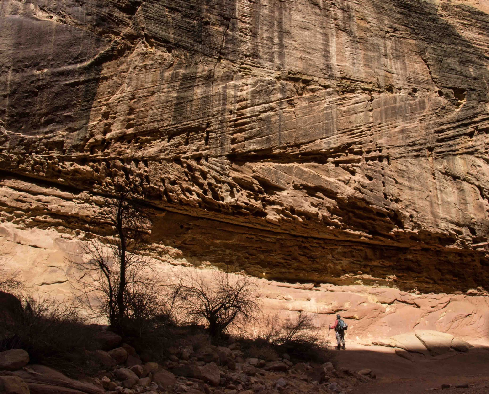
Grand Wash is a dry gravel streambed that cuts through the Fold. Even though it was a fairly cool day, the hike was pretty warm due to the heat radiating from the rock walls:
Unlike the walls of Zion (which are smooth and sheer), these tended to be a lumpy jumble of strata:
At one point, the gulch cut through a fossil dune field -- note that the layers are not parallel but intersecting, as one set of dunes overlapped another:

Note the similar pattern of the overlapping "mini-dunes" in the lower left corner of this shot -- these wind-blown sand ripples have not yet been fossilized. The robot on the right is the Mars Curiosity rover:
The "downstream" end of the Grand Wash ends at the Fremont River, which also cuts through the entire Fold. We soaked our bandanas in the river to cool ourselves off. Although the river was full of sediment, it is easy to image how grateful the settlers were to find a reliable source of water in this arid region:
The shady "narrows" portion of the Grand Wash was nice and cool:
That evening, an intricate lenticular cloud parked itself over the crest of the Fold:
April 9: Boots don't last forever; this old friend had guest-starred in many dramatic "boot shots." May its sole rest in peace:
On our way into the park, we stopped at a fruit orchard in blossom -- many of the trees are over a hundred years old and are still bearing fruit:
We took the Cassidy Arch trail -- it was crowded but worthwhile. Just as we got there, the members of a Search and Rescue climbing crew were practicing their rappelling skills. Felice inched close to the edge of the cliff and caught this climber in mid-descent -- note the climber's shadow on the left leg of the arch:
After carefully surveying the route, Felice was able to walk out onto the top of the arch itself:

We had lunch sitting near (not on) the edge of the cliff:
The feature on the right side of the shot is known as "Fern's Nipple:"
April 10: We hiked to the Golden Throne. It was a pleasant hike but not particularly picture-worthy -- the trail followed the edge of the cliff until it arrived at the base of the Golden Throne. (We did see some bighorn sheep, but they were molting and refused to pose for us.)
The Golden Throne is the peak on the right -- it was unusual to see yellow rock, instead of tan or red:
To us, the most interesting part of this hike was that the trailer was parked just on the other side of the Throne, about four miles distant and two thousand feet below. We had been admiring those "interesting mountains" all week, without realizing that the peaks were a featured attraction in Capitol Reef.
April 11: This is a view of the Golden Throne from the trailer in the early morning light -- the Throne is on the left side of the shot:

Our original plan was to go directly from Capitol Reef to Zion. But Felice looked again at the map and realized that Bryce Canyon was only a little bit out of the way. So we called an "audible" at the line of scrimmage and changed our plans on the fly -- it's very liberating to be able to do that!
As we left our campsite, I requested a shot of the truck and the trailer slowly and carefully negotiating the twisty dirt road. Fortunately, the trailer has a very low center of gravity:
And off to Bryce (and later Zion) in Part 2.