Wednesday, October 15, 2014

A Month in Northern Washington, Sept. 2014: Part III (the Olympic Peninsula)

 September 18:  We took the ferry to Pt. Townsend and then camped out in a lovely driveway, courtesy of our dear friends Caroline and Kate.  They have a beautiful second home in the hills, with a view of the Olympics.   

September 19:  We drove the truck to Port Angeles and took a short hike near “Heart O’ the Hills” campground -- the trail was called “Heart O’ the Forest.”  (Apparently, a moist climate causes gratuitous contractions.)  This was a true rain forest -- every inch was covered with ferns and mosses:
  

The leaves on this understory shrub were (no kidding) three feet long and a foot wide -- that's the tip of Felice’s pole in the bottom center of this shot:

That afternoon, we went back to Caroline and Kate’s -- and they arrived from Seattle with steaks!  Quite a nice change from ramen and lentil soups.

September 20:  We relaxed with Caroline and Kate on their deck -- Penny the GoldenDoodle looked at the camera, right on cue:


We then towed the trailer an hour west to Heart O’ the Hills campground and found a campsite near a creek.  That afternoon, we drove up to Hurricane Ridge -- it was yet another clear and warm afternoon.  Mt. Olympus dominated the skyline to the southwest:


We took the Hurricane Hill trail -- the visibility from the top was excellent, with Mt. Baker to the northeast, Glacier Peak to the southeast, and all of British Columbia to the north.  This video provides a sample of the view:


Along the trail, an Olympic marmot (different from ordinary marmots) posed for Felice as he munched nonchalantly on a lupine bush:


We also came across a family of ptarmigans, chasing (and eating) grasshoppers in the meadow -- the birds looked and sounded like drab muted turkeys (which would be a good name for a rock band):


Late that evening, the sky was still clear, so we drove back up to Hurricane Ridge from the campground.  The Milky Way illuminated the glaciers on Mt. Olympus:


(Full disclosure:  although we could see the Milky Way clearly with our own eyes and could just make out the glaciers on the mountain, this picture reveals far more detail than we could really see.  It is a 30 second time exposure at an ISO of 1600.)

September 21:  We took an easy hike (a little over four miles round trip) to the Goblin’s Gate area on the Elwha River:


It was a hot day, probably around 80 degrees, so we spent a lot of time wading in the clear, cold water and enjoying the warm breeze.  Instead of a boot shot, this is a feet shot: 


September 22:  We moved the trailer from Heart o’ the Hills to Sol Duc campground.  Once again, our campsite was at the water’s edge.  That afternoon, we hiked from the campground up to the falls and spent a lot of time hanging out by the water:


Felice clambered out onto the rocks for this shot -- she is in the upper-right corner:


In this picture, she is on the bridge overlooking the falls:


We hiked upriver a little way:


Back at the campground, we actually made a campfire, a very rare event for us:


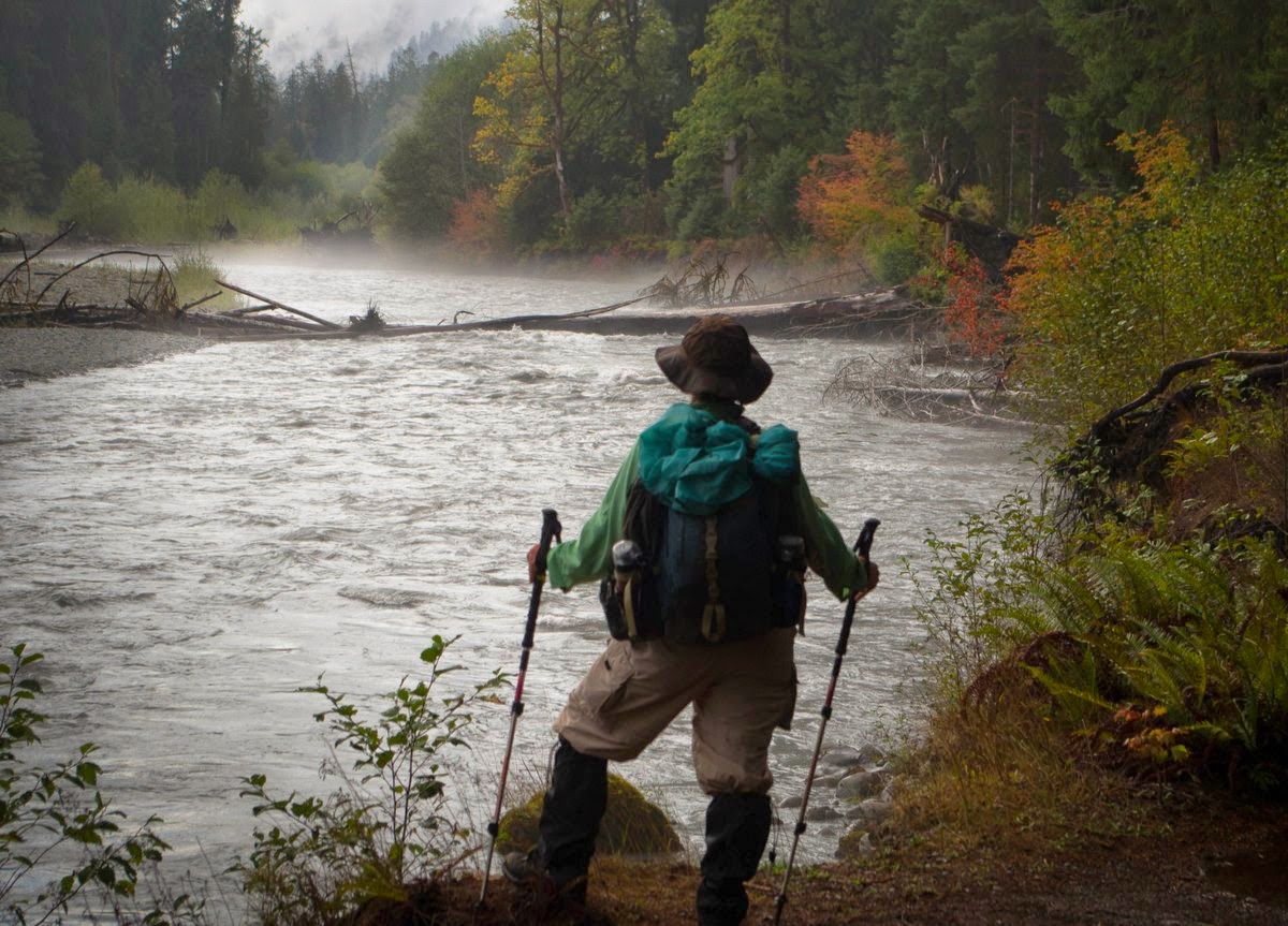
September 23:  It started raining during the night and rained off and on throughout the day.  We decided to try the North Fork of the Sol Duc River, a seldom-used trail that requires a tricky river crossing.  We put on our special water hiking shoes at the edge of the river, and I wore our hiking boots around my neck to keep them dry:


The trail followed the river very closely.  The vine maples were brilliant, especially because the leaves were wet:


September 24 :  We took the trail along the left bank of the main fork of the Sol Duc River, which was pleasant but unremarkable -- the trail was not quite at the river for most of the way, so we could hear the water but could not see it very often.  We came across a fallen tree that had split in a spiral pattern:


When we got home, I did a little research and discovered (surprisingly) that no one really knows why some trees grow in spirals -- maybe the tree is better able to resist high winds.  

Back at the falls, we could see that the heavy rains of the past two days had caused the river to rise a lot -- compare the first shot (from the 22nd) with the second shot (taken on the 24th):


This is a quick video of the falls:


That evening, we hung our soggy garments from the plethora of hooks we’ve installed in the trailer, for exactly this reason; the trailer looked like a mobile laundry room:


September 25:  After a quick stop in the town of Forks for laundry and groceries, we moved the trailer to the Hoh River campground, again finding a campsite right on the river.  It rained very hard all night long; during the heaviest downpours, the pounding on the roof of the trailer woke us up. (Usually, rain has the opposite effect -- excellent "white noise.")

September 26:  We took several small hikes in the rain, in the vicinity of the campground.  This huge spooky maple was on the Hall of Mosses trail:


The river looked rough and uninviting, clouded with a big load of glacial flour:


The mist and fog came and went, rolling up and down the river:


September 27:  The rain stopped, and we watched the sun come up over the river from our campsite:


After breakfast, Felice spotted an eagle across the river -- in the first shot, I have highlighted the bird in the top of the tree:


Then Felice zoomed in:


We set out on the Hoh River Trail, through a dense rain forest -- it was so freakishly green that it looked like a photo taken with the wrong white balance setting.  This picture is absolutely accurate -- this is how the whole jungle looked, mile after mile, a riot of thick vegetation:


The vine maples were set off against the blue-gray river:


Felice caught this little vine maple seedling with stylish two-tone leaves:


This banana slug gets the prize for “Most Banana-ish” -- it looks perfectly ripe:


We made it all the way to Five Mile Island and back -- with a stop for a therapeutic foot soak in very cold water:


We toasted the end of our stay in Washington with another riverbank cocktail hour:


Late that night, I stepped outside the trailer, and both Orion and Sirius were rising over the river and the mountains to our south. Sirius is in the notch of the mountains.  The bright pink star at the top is Betelguese.  There is a fog bank up against the mountains, and the Hoh River is in the left foreground:


September 28:  We left the Hoh Valley and drove down through Washington to the Oregon Coast.  We stayed in Nehalem Bay State Park, right on the beach.  We had heard that Dungeness crabs were in season; we found a nearby place called Kelly’s Brighton Marina where they cook the fresh crab right on the dock.  The crab was delicious, especially on a warm, sunny evening at a picnic table overlooking the harbor.  That’s Kelly himself in the red hat:


That night, we took a walk on the beach near the campground.  The moon was setting over the ocean and yet the Milky Way was visible, an unusual combination.  This picture (a 30 second exposure) makes it look like the moon was full, but it wasn’t -- it was about a quarter moon:


September 29:  On a rainy day, we drove to Grants Pass to Valley of the Rogue State Park.  The riverbank was lined with huge blackberry bushes, but we were a month too late for the peak of the season.

September 30:  On a whim, we drove to Lassen National Park, since the weather was cool and we were in the neighborhood.  We stayed at Manzanita Lake Campground, at about 6000 feet in elevation.  Very pretty, but lots of schoolchildren noisily enjoying “outdoor science camp.”

October 1:  On a clear, cool day, we drove up the mountain toward the high country; on the way, Felice caught this reflection in Hat Creek:


Starting at about the 8,000 foot level, we hiked into “Bumpass Hell” --Bumpass was the last name of the poor fellow who discovered the geothermal area and then stepped into a hot spring, scalding his leg so badly that it later had to be amputated.  As we got near the crater, we could hear it and smell it before we could see it.  The steam vents were roaring, and the sulfur in the steam had discolored the rocks:


This quick video provides an overview:


There were quite a few vigorously boiling mud pots -- Felice zoomed in on a mud mini-geyser:


These two short video clips show the mud pots:


Later that afternoon, we hiked down to Kings Creek Falls, which was nice but a bit of a disappointment -- there was no safe way to get down to the base of the falls.  Instead, this is a side view; Felice is the little blue dot in the top right corner: 


October 2:  We made a quick stop in Oakland to see Matt and Greg, and of course Haydn.  And then home.

Tuesday, October 14, 2014

A Month in Northern Washington, Sept. 2014: Part II (the Mount Baker area)

September 10:  We got a campsite at Silver Fir Campground, right by the river.  That afternoon, we drove up to the Heather Meadows area to enjoy the cool but sunny weather.  There was a patch of late-season pink fireweed conveniently posing in front of Mt. Shuksan:


Every time we come here (this was our third trip to the Baker area!), Felice just can’t get enough of Shuksan -- so dramatic and craggy:
 

Me, too:


We were delighted to find that there were plenty of ripe wild blueberries in the Artist Point area:


As we headed down the hill to the campground at sunset, we passed Picture Lake:


September 11:  We just had to try the long Ptarmigan Ridge trail; in most years, there are tricky patches of snow (even in September), but all of it had melted, making it much easier than usual, so off we went.  As we started out in the morning, Mt. Baker loomed in the distance; we would spend the whole day inching closer to it:


From many points along the trail, we had views of both Baker and Shuksan, depending on which way we were looking:


The trail contoured around huge glacial cirques -- we felt like ants crawling around the edge of an empty swimming pool, with cubic miles of air scooped out between us and the nearest mountain ranges.  The yawning glacial valleys seemed even wider and deeper than in the Sierra -- to get a sense of the scale, Felice is on the trail in the lower left corner:


This video shows the surrounding skyline -- the audio was wiped out by the blustery wind:


We did not go quite to the end of the trail at Coleman Pinnacle, but we got pretty close to Mt. Baker:


Felice captured the icefall on Rainbow Glacier:


From our perch at the edge of the volcano, we could clearly see Mt. Rainier to the south, 135 miles away (really!).  Old-timers that we met on this hike told us that they had never seen Rainier from Baker.  In this shot, Glacier Peak is on the right side of the skyline, only 60 miles away:


We sat on the edge of the canyon for a while, just getting our fill of the mountain:


September 12:  The amazing weather was still holding, so we took the Skyline Divide trail on the north side of Mt. Baker.  We could see snowy mountain ranges marching to the northern horizon, far into British Columbia, certainly more than 100 miles away.  The green alpine meadows rolled along the ridge toward Mt. Baker:


We found a late-season patch of backlit lupine:


The ripe blueberries were irresistible -- quite a lovely setting for berry picking:


The only problem is that the berry bushes were very close to the ground:  we had to sit down to pick the fruit, and it was impossible to avoid sitting on the juicy berries.  I told Felice that her windblown pants looked like a cup of unblended yogurt -- “fruit on the bottom:”


September 13:  We took the Lake Ann trail, which approaches the toe of Lower Curtis Glacier on Mt. Shuksan.  There were still a few wildflowers near the streams:


Along the heavily wooded trail, we were able to catch brief glimpses of Mt. Baker:


Up at the saddle near Lake Ann, the terrain opened up for even better views:


The last time we had taken this trail, Felice fell and cut her leg on some sharp rocks near the lake, and we had to turn around before we got to the overview of the Upper and Lower Curtis Glaciers.  This time, we made it all the way, albeit slowly (because of my foot):


This quick video provides an overview:


Felice zoomed in on the details of the toe of the lower glacier -- the ice was really ice-blue, and the layers in the glacier were easily visible:


The deep horizontal crack (top center in this shot) at the head of the glacier, where it separates from the upper wall of the cirque, is called a bergschrund -- it is probably a hundred feet wide, and at least that deep:


September 14:  Even though it was another lovely day for hiking, my foot needed a day of rest.  We drove up to Artist Point -- Felice walked by herself on the nearby trails.  The reddish bushes in the foreground are full of blueberries -- she had to sit on the ground to get the bushes and the mountain in the same shot:


Meanwhile, I took a nap in the shade of the truck:


That afternoon, we moved from Silver Fir to Douglas Fir campground, for a couple of reasons.  First, we wanted to do a couple of hikes closer to the town of Glacier, instead of commuting from Silver Fir.  And second, we had picked up a mouse hitchhiker in Silver Fir, even though we had carefully mouse-proofed the underside of the trailer and had stored all of our food inside tough plastic bins.  When we trapped him with our humane trap, he came back after we released him in the bushes.

The next time we caught him, we tossed him into the river.  He swam right to shore and came back.  We eventually figured out that our campsite was a little too close to the dumpster, a mouse magnet.  So we were hoping for better luck at Douglas Fir -- more on that later.

September 15:  We hiked up to Heliotrope Ridge, overlooking the Coleman Glacier.  The stream crossings, which are usually pretty tricky, were not bad at all, perhaps since it had been several weeks since the last big rainstorm.  Even so, the meltwater pouring out from under the ice at the toe of the glacier was roaring -- the falls must have been several hundred feet high, since this shot was taken from about a mile away:


Felice took a closer view of the falls -- they were gray-brown, laden with powdery glacial flour scoured out of bedrock by the grinding of the ice -- essentially “mountain soup:”


While we were munching on our sandwiches at the edge of the cliff next to the glacier, Felice noticed that there was a person way out on the ice, all alone, a very dangerous place to be.  In this wide shot, I have highlighted the foolhardy hiker in the left center -- he is a dot on a jumbled sea of fractured and rotting ice:


This next photo is zoomed in a little more:


And this is even closer -- he is in the lower left corner:


We never discovered how he got himself off the ice and up the cliff -- as this shot shows, the lateral moraine is a high vertical wall of dirt and rubble, very unstable.  The edge of the glacier is under a thick coating of dirt, just to the right of the cliff:


We climbed up along this ridge from the forested area to the edge of the glacier, being careful to stay back a few feet from the edge; we were right next to a tangle of seracs, the blocky columns of broken ice:


We sat there for a while, listening to the glacier crumble, as meltwater dripped off the glacier and small rocks fell out of the dirty ice, rattling and bouncing into the crevasses.  Some of the rocks stuck in the ice were pretty big:


Even though it was a warm day (probably in the mid-70s), the wind coming off the glacier was fresh and cold -- it felt like someone had accidentally left the freezer door open.  We could see the peak of Mt. Baker above the icefall:


(By the way, these pictures make it look as though we were really climbing through difficult and tricky terrain.  We weren't.  It was steep but not unsafe, more of a tough walk than a climb.)  

From lower down on the trail, we could see the whole sweep of the glacier field, spilling down several miles from the top of the mountain to the toe of the glacier:


This quick video also shows the full extent of the glacier -- Felice started laughing and said that I sounded like I was doing a parody of Lowell Thomas in an old-time travelogue:


That evening, during our usually-relaxed post-dinner reading period, we heard another mouse in the cabinets.  Not relaxing at all.  I baited the humane trap with peanut butter, and it soon slammed shut.  After several nights of mice tap-dancing in the cabinets, we decided that we had finally run out of humane feelings.  We put some water in a bucket outside the trailer, dumped the mouse into the water, and put a piece of wood over the bucket.  I re-baited the trap. 

That night, every 90 minutes or so, we would hear the trap shut, and I would clamber out of bed (foot and all) and take the trap out to “Auntie Felice’s swimmin’ pool” (the bucket).  In the morning, there were four former mice.  We dumped the bucket, and that was the end of our mouse adventure.

September 16:  We hiked up to Excelsior Ridge, with terrific views of (guess who?) Mt. Baker across the valley of the Nooksack River.  I am told that “nooksack” is an Indian slang word meaning “sleeping bag,” but I am not sure that is correct:


  Along the trail, we caught another late-season flower show -- we could almost imagine what this meadow looks like in mid-summer: 


We found an astonishing quantity of blueberries and huckleberries near the Damfino lakes.  Supposedly, the lakes were named when a ranger was asked the name of the nameless lakes.  (He said he didn’t know -- get it?)  The reddish bushes on either side of Felice were loaded with mixed berries:


The huckleberries were sweet, flavorful, plentiful, and huge -- almost the size of ordinary table grapes.  (They taste like blueberries, but not exactly -- hard to describe.)  Even better, the bushes near the lake were tall, so that we did not have to bend over or sit down.  We picked a couple of water bottles full, and enjoyed them for several days with yogurt.  The stains on our fingers eventually faded:


September 17:  We returned to Bellingham for groceries and so forth, before heading off to the Olympic Peninsula.