Sunday, July 22, 2012

July 2012: Very High Sierra

(Remember to click on a picture to enlarge and click "back" to get back!)

We wanted to get away to the mountains for a week or so, but the weather service had predicted a heat wave.  The solution was obvious: get up as high as possible into the cooler air, and stay there!  As it turned out, we spent a full week at 9400 feet and above.  

Thursday, July 12: We had targeted a boondocking campsite in the Toiyabe National Forest, somewhere between Lee Vining and Bridgeport in the Eastern Sierra.  The exact location of this campsite is a secret; it's at 9400 feet, west of Highway 395, in a remote area.  With our new trailer (which is modified for towing on rough dirt roads), we had no trouble getting there; but when we arrived, we were very surprised to find someone parked in "our spot," just taking in the view of Mono Lake.  Even more surprisingly, he immediately left.

Rain was predicted, so we set up our awning with a sharp tilt to shed the rainwater, a trick we learned in the Northwest.  And we put up a big tarp near the trailer, to use as a work area, draping it over ropes tied between the trees:


Because the soil was so rocky, I couldn't set anchors for the sides of the tarp.  Instead, I tied ropes around logs and then anchored the logs with big rocks:


We got a little bit of rain that night, and we saw thunderstorms all week long over the desert and Mono Lake, but we didn't get any more rain after that.

Friday, July 13: We hiked to Green Lake and East Lake.  Because the trailhead was at about 8000 feet, it was pretty hot for the first few miles, until we got up to the lakes at about 9500 feet.  Even though it was a fairly dry winter, there were still quite a few flowers in the meadows:  


There were fields of "swamp onion," which smelled more like garlic.  Supposedly, these are edible:


Saturday, July 14: We hiked the Virginia Lakes trail, which starts at almost 9800 feet and goes up to 11,300 feet.  We passed a log cabin near Cooney Lake:


As we got up into the high country, we saw quite a bit of metamorphic rock that had been lifted up by the granite of the Sierra.  In this shot, you can see that the shale has been tilted 90 degrees from the horizontal to the vertical:


Black Mountain, at about 12,000 feet, towered over the trail as we climbed up to the summit:


Up at the summit, we had lunch at two little melt ponds.  The snow bank had formed a small bridge:


Going off-trail, we contoured along the west side of the summit ridge, where we got a view of the interior of the Sierra, from Green and East Lakes to the north, all the way into Yosemite on the west and south.  That's Summit Lake behind me in the middle right portion of the picture:


Heading back down toward the trailhead, we could see the broad "U" shape of the valley – imagine this entire canyon, a mile across and 3000 feet deep, filled with a river of glacial ice:


Sunday, July 15: We had intended to take a fairly short hike up to Dunderberg Lake.  When we got to the lake, we found two middle-aged guys camped by the stream -- apparently, they camp at the lake to ski on the snow banks, so that they can say that they have skied in every consecutive month.  (To each his own!)  But they tipped us off to a great hike beyond the lake to Kavanaugh Ridge, at 11,000 feet.  Although the air was cool and breezy, there was no shade because we were far above tree line.  We climbed (carefully) out onto the rocky edge of the cliff, giving us tremendous views of the interior of the Sierra:

The skiers had also mentioned a small glacier on Dunderberg Peak.  It was right near Kavanaugh Ridge, and we could see where skiers had hiked up and had skied down almost to the edge of the wall over the melt pond – the water was, of course, almost freezing, and the wall was about ten feet high – not a great place for skiing, since a fall would probably be fatal:


A fairly large iceberg (perhaps 10' x 5') had broken off of the wall and was floating around in the pond:

Note the pink snow in this picture – I am told that there is a pink algae that grows on snowfields during the summer.  This picture is not "photoshopped" -- the snow is really pink, and the underwater ice is really turquoise:


The edge of the glacier hung over the pond:


As we sat at the edge of the glacier, a little iceberg, about 2 feet wide, floated toward me – I was able to push it back out into the middle of the melt pond:


(By the way, notice the mound of gravel behind me in that shot -- this is actually the terminal moraine of this little glacier, and the pond is sitting in the cirque carved by the glacier in the mountainside.)

On our way back down to the trailhead, we could see storm clouds gathering over Mono Lake and the White Mountains – the tallest mountain in the center is Boundary Peak, over 13,000 feet high:  

That afternoon, we set up our "snack area" in the meadow next to our campsite, overlooking Mono Lake and the desert to the east – in this picture, you can just see the trailer, hiding back in the trees:

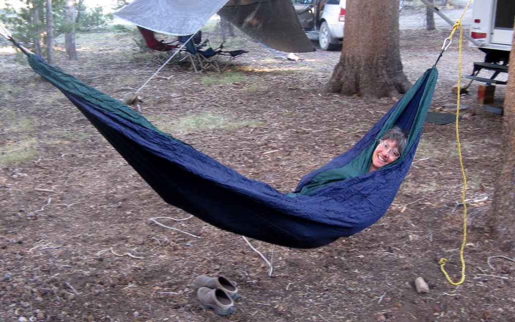
We also set up our new two-person hammock -- very comfortable and easy to use!  It was very pleasant in the late afternoons, rocking while the cool breeze blew through the trees overhead:


It's too bad that the pictures can't capture the peace and quiet of this campsite -- we were many miles away from any other people.  The only sound was the wind in the trees.  The days were generally cool and amazingly bug-free; the nights were pleasantly chilly.  After sundown, it was too cool to sit outside.  (We could not make a campfire because of the fire restrictions in the national forest; and we rarely make a fire anyway, since there is just too much risk of starting a forest fire.)  Nor can the pictures show the long, leisurely meals.  As usual, we brought our favorite foods with us -- breakfasts were eggs, salsa, and toast, and dinners were (e.g.) barbecued beef, fresh green salad, bread, and a pretty good Zinfandel.  Yes, boondocking is hard work -- all of the food and water must be carried with us, and we have to set everything up ourselves, and the terrain is rough.  But the relaxation is priceless.

Late that evening, just before bedtime, we went outside to look at the stars and were surprised to see lightning flickering up and down the eastern horizon, over the Nevada desert.  It was so far away that it was completely silent; the lightning illuminated the cloud banks over the mountains, giving them an orange glow.  Every so often, we could see the lightning bolts themselves, forking into the mountaintops.  The whole display was reminiscent of a fireworks show -- very memorable!

Monday, July 16:  We drove into Yosemite up Tioga Pass to the Spillway Lake trail, which began at around 9500 feet and ended at around 10,500 feet.  This was a surprisingly delightful trail, with a mix of shady forest interspersed with sunny meadows.  There were plenty of flowers:


Even the deer seemed to prefer the shade:


Given the altitude and the harsh conditions, we were surprised to find a tiny frog hopping along the trail: 


The lake itself was pleasant, but the lush meadows surrounded by craggy peaks were right out of “The Sound of Music:”


On our way back down to the trailhead, we had some terrific views of Mt. Conness to the north, around 12,000 feet -- it has a pretty large glacier on its north side, near the 20 Lakes Basin:


Mammoth Peak, at 12,000 feet, was just to the west of the trail – I really liked the way that the ground lupine in this swale echoed the shape of the mountain, so I had to get down on the ground to get this shot:


Felice took a shot of the same area – I looked at her camera and asked, “Where was that log in the foreground of your shot?”  Then I realized that I was the log:


Even though Indian paintbrush flowers are very common, I just had to capture this one in the late afternoon light:


That evening, we were treated to a spectacular display of lenticular clouds, which are "standing waves" of condensation: moist air flows up over the mountains, condenses, and then descends.  The area of condensation is stationary, even though the moisture continually flows through the cloud.  These clouds were south of our campsite, on the leeward side of Tioga Pass:


Tuesday, July 17: We drove up Tioga Pass to the Tuolumne Meadows area.  The trailhead to Tuolumne Falls began at Lembert Dome, which we had climbed a couple of years ago:


The trail was a bit of a disappointment – the first 3 miles were very sandy, and the pack animals had messed things up pretty badly.  But all was forgiven when we got to the falls:
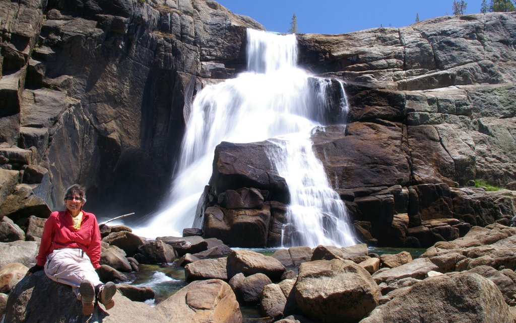


Felice took one of her patented “boots” shots:

The canyon downstream beyond the falls was very enticing – Felice climbed up onto a boulder to get a better view:


But the hike was so long – about five miles each way, with almost a thousand feet of elevation gain on the return – that we could not go down the canyon any further.  It was a long, hot walk back to the trailhead.

Wednesday, July 18:   As we reluctantly left our campsite for the drive home, we got a picture of the week's collection of used bandannas, which we had hung on the awning to dry -- this is in lieu of Tibetan prayer flags, or a string of trout:

The road out of the national forest is very rough – at one point, there was a particularly deep ditch that would have given me a lot of trouble with my old trailer, and I wanted to see how much clearance we had with our "raised up" trailer.  As you can see, there is almost a foot of clearance below our plumbing, which is more than enough.  This may not seem like a big deal to most people, but to a boondocker, this is a very beautiful picture:


That night, shortly after we pulled into Lone Pine, we received a bon voyage present from Mount Whitney:

This is the same shot edited in Lightroom, a year later:


Sunday, May 27, 2012

May 2012: San Francisco and Santa Cruz

Matt was graduating from med school at UCSF, so we decided to take a quick LMIC trip to the San Francisco Bay Area. We stayed at an RV park in South San Francisco just a few hundred yards from Matt's apartment, which was an amazing coincidence. The RV park wasn't wonderful – just a suburban parking lot – but tremendously convenient. 


 May 13: After looking at Matt and Greg's lovely new house in the Oakland Hills, we took a hike in Redwood Park, just up the hill from their house. This is a huge park with excellent hiking trails and lots of shade – here we are with Haydn the wonder dog:


(As always, click on a picture to enlarge, and then click "back.)


May 14: Matt's graduation ceremony was very moving. The high point was when Matt approached the front of the stage for "hooding:" we stood on the left side of the stage and watched him walk to the right side! The situation was quickly remedied -- Felice is shaking the Dean's hand, and he is saying (in a British accent), "My goodness, you nearly had to put the hood onto someone else's son!"


 The rest of the day, we strolled around San Francisco, eating phenomenal dim sum and generally enjoying the cool, sunny, breezy weather. 


 May 15: We towed the LMIC to the Santa Cruz area. We stayed at an RV park in Felton, just across the river from Henry Cowell State Park. That afternoon, we had time for a bike ride through the park – the irises were in bloom along the trail:


 May 16: We took one of our favorite "bike and hike trails" in Big Basin State Park, on the "Skyline to the Sea" trail. We started at Waddell Beach. The trail is very gentle, winding through ferns and redwoods alongside the creek. This photo makes it look like Felice was really speeding – in fact, it is a long exposure with a tight f-stop: 


After 6 miles of riding, we locked the bikes, changed into our hiking clothes, and headed upstream toward Berry Falls: 


This is a view of Berry Falls from a couple of hundred yards away, on another trail:


Further upstream, we came to Gold Falls: 


And on the way down, we scrambled into the stream bed below Silver Falls, where Felice saluted the waterfall in her customary style: 


 The trail is Felice's favorite type for a mountain bike ride – softly carpeted in leaves and well-shaded:


 May 17: We took a long, strenuous ride through the Forest of Nisene Marks, roughly 11 miles each way with about 1800 feet of climbing. The bottom portion of the trail was through redwoods, and the top of it was through a mixed oak forest. 

May 18: We hiked through the Fall Creek area of Henry Cowell State Park, mostly alongside the stream. That evening, we visited with my cousin Sol, Brooke, Marlon, and Mose, and my Aunt Norma and Uncle Fred. We presented the boys with a desk made in the mid-1960s by my grandfather (their great-grandfather); the desk was made for Katie (Sol's sister) and was then used by William, by Sol, by Ben, and by Matt.  After all of that hard use (including a broken leg), I repaired it and restored it.  Sol, Mose, Brooke, and Norma posed with us; Marlon and Fred were both camera-shy:


Monday, March 12, 2012

Yosemite Valley, March 2012

(Remember to click on a picture to enlarge and then click "back" to get back. If you click again, the picture gets even bigger. I apologize in advance for the number of photos – taking pictures in Yosemite in the springtime is like shooting fish in a teacup. You can't miss.)

We have always avoided Yosemite Valley; to quote Yogi Berra, "Nobody goes there anymore, it's too crowded." But we figured that in early March, when the weather is cold and there are no major holidays, we would take a chance. We are very glad that we did: the park was virtually empty, the falls were flowing fairly well, and the campground was quiet.

Sunday, March 4: The drive to Yosemite was a pleasant surprise – we had remembered it as an endless ordeal, but it only took seven and half hours, even while pulling the trailer. We were greeted with the usual spectacular view as we came into the Valley, which provided a perfect backdrop for the obligatory portrait of our new trailer:


After getting situated in Upper Pines Campground, we took a late evening walk to the bottom of Lower Yosemite Falls. The moon was almost full – this was a 30 second exposure at f 3.5, with an ISO of 800:


Monday, March 5: We hiked up to Nevada Falls, a fairly ambitious hike (especially because the shorter Mist Trail route, via Vernal Falls, was closed, supposedly because of ice). As it turned out, though, the longer "winter" route was quite icy; our microspikes came in very handy. Many people turned around because of the difficult conditions. We "boulder hopped" (carefully) to the base of the falls, which were thunderous -- there was no one else around:


These falls are 600 feet high – in this video clip, the "snowcone" of frozen spray can be seen at the base of the falls:


(The falls were so loud that the noise overwhelmed the microphone on the camera -- hence the odd audio.) We then hiked back down to the top of Vernal Falls, expecting that we would have to slowly and carefully retrace our steps over the icy portion of the trail. At the falls, we met a family with young children and asked them how they had managed the ice. They responded, "What ice?" It turns out that they had used the Mist Trail route and that there was no ice at all. We happily took that shortcut down the hill, and we were very glad that we did. Otherwise, we would have missed the vivid rainbow at the base of the falls -- this picture might be worth double-clicking:


After some experimentation, I discovered that my polarizing filter intensifies the colors of the rainbow. This was a half-second exposure at f 27, with an ISO of 200. Unfortunately, no photo can show the mesmerizing pulsation of the rainbow: the colors seemed to wave rhythmically, as the water surged over the falls. It looked as though the colors were springing directly out of the dark rocks, into the sunlight.

(This is an edit, added in late 2013 -- after learning how to use Lightroom, I went back and fiddled around with the preceding picture, hoping to get a slightly more realistic tone to the water and the rock.  The shot was taken in the late afternoon during "golden hour."  Even though the original was a jpeg, rather than a "raw" file, and even though I could not change the white balance, I was able to tweak the settings to achieve something close to the desired result, below.)


On our way back down to the Valley, we were entertained by a pack of almost-tame mule deer grazing by the side of the trail:


Tuesday, March 6: As predicted, there were snow showers all day long, which interfered with the views. Nevertheless, we managed to have fun – we spent most of the day hiking around the meadows in Yosemite Valley:


Later in the day, Half Dome peeked through the clouds:


Wednesday, March 7: The night had been very cold and windy (although we were perfectly comfortable in the trailer – hurrah for insulation!). When we emerged, we were greeted by our neighbor, a small young Chinese lady, who was carrying bags of food. She asked us if we wanted any of it, because she was leaving unexpectedly. We asked her why she was leaving; she told us that she had spent the entire night shivering in her tent as a bear walked around and around, sniffing and growling. Apparently, she had not washed out her cooking pan and had stored it inside her tent, and the bear reached in and grabbed it! We asked her how she knew it was a bear. She told us that she could see its shadow in the moonlight on the walls of her tent: "I was prepared to die!" she announced.

After she hurriedly packed up and left, we opened our mysterious care packages to discover that she had left us (among other things) an enormous coconut cream pie and a huge pomelo, which is similar to a grapefruit (but much more fibrous, as we later discovered):


We then embarked upon our most ambitious hike of the week, from the valley floor to the top of Yosemite Falls, a round-trip of almost 8 miles with a vertical gain of over 2700 feet. This hike was strenuous, but not quite a death march. In the heat of the summer, though, this would be a very difficult hike. Shortly after passing Columbia Point, we were greeted with our first full view of the upper falls:


Note the patches of snow on the walls of the canyon – during the very cold and windy night, the falling spray had frozen in midair and had adhered to the rock. As we were hiking up the trail, and as the sun hit the patches of ice, they would suddenly crack off and tumble down the mountain, sounding exactly like nearby lightning and thunder (or, worse yet, a rockfall), echoing through the canyon. The frozen spray also formed a huge snow cone at the base of the falls:


The upper falls are over 1400 feet high – in this clip, we followed the water from the top all the way down to the snow cone:


From the upper portion of the trail, we could see that Half Dome had been sprinkled with fresh snow:


It took four hours to get to the top (with frequent stops). The viewing area at the edge of the cliff was covered in ice; but Felice conquered her vertigo and was (rightfully) rather proud of herself:


On our way back down (which took another three hours), we stared up at the shadowy sheer cliffs hanging over our heads, rising more than 1000 feet straight up from the trail. One hopes that no rocks will fall:


By the time we were nearing the bottom, the setting sun had begun to inflame Half Dome:


Later that evening, we decided to head back out to the meadow near Yosemite Falls to watch the moon rise over Half Dome. That's Mars in the upper left-hand corner of the picture – this is a 20 second exposure at f 5.6 with an ISO of 200:


Thursday, March 8: We drove up to Badger Pass for a snowshoe hike to Dewey Point, a round-trip of over 6 miles on a trail that heads north from Glacier Point Road. The snow depth varied widely, from none to about two feet:


At times, we decided to carry our snowshoes and hike, rather than shuffling along slowly – this meant that I was sometimes loaded up like a pack mule:


At the end of the day, we took a short walk to Bridal Veil Falls. The swirling wind was whipping the water from side to side:


The snow and frozen spray contrasted sharply with the orange rocks at the base of the falls:


Friday, March 9: We took a walk around Mirror Lake. The most interesting part was the Ahwiyah Point Rockslide, a huge debris field resulting from exfoliation of an 1800 foot granite cliff face on the north side of Half Dome. This slide, which took place in March of 2009, was so cataclysmic that it registered as an earthquake with a magnitude of 2.4. Surprisingly, the talus was not composed exclusively of huge boulders, as one might expect; apparently, the failure of the mountain was so violent that much of the rock shattered during the fall and on impact, creating a mess of sand, gravel, and boulders:


The source of the slide can be seen at the very top of this picture, far above the trail:


Although we are not sure, it seemed that a couple of very large boulders high on the cliff were dislodged by "frost wedging," in which the freezing and thawing of water in the cracks between the rocks during the springtime will eventually pry the rocks apart. We could see huge "sockets" of raw unweathered rock at the top of the cliff, where the boulders had broken away. From there, I would guess that the boulders dislodged other precariously-perched rocks, and the slide was underway.

Late that evening, we decided to pay another moonlight visit to Lower Yosemite Falls. We were all alone at the base of the falls, a rare privilege. We had heard that there might be a "moonbow" during the full moon, but we couldn't see one when we arrived. I decided to take a time exposure of the falls, mostly because the "rooster tail" at the bottom was so prominent. After the camera processed the image, we were shocked to see the elusive moonbow:


This is the same shot edited in Lightroom, more than a year later:


After the camera had revealed the moonbow to us, we were able to see a white streak in the air, but we still couldn't see the colors ourselves. It turns out that since the moon reflects the light of the sun, moonlight contains all of the colors in sunlight. It's just much fainter. Here is a closer view of the rooster tail and the moonbow:


As we left the falls, we were able to see both the upper and lower falls at the same time:


(All of these shots were at 30 seconds with an ISO of 800.)

This is the same shot, cropped and edited in Lightroom about a year later:


Saturday, March 10: We packed up and headed home; but first we stopped off at Mariposa Grove for a short hike among the sequoias. Since this was a Saturday, the grove was fairly busy. We had heard that this was a terrific sequoia grove, but (frankly) the groves at Sequoia National Park are much larger and denser. We ended the trip with the usual mandatory sequoia shots. The first picture is the entire tree, with Felice at the base. If you enlarge the picture, you can see her at the bottom. The second picture is an excerpt for perspective, so that you can actually see her: