Monday, October 15, 2012

Six Weeks in the Mountains: Part I (Glacier National Park, Two Medicine Area)

(To enlarge a photo, just click on it; click "back" to get back.  To watch a video again, click on the counterclockwise arrow in the lower-left corner.)

We had visited the Rockies briefly in 1980 and again in 2005 for a bike tour, but we had never been able to thoroughly explore this amazing region.  So, after months of planning and arranging, we set out on a six-week odyssey in late August of 2012.  We had a very tentative itinerary; we didn't make any reservations, hoping to keep our options wide open.  It worked out better than we had imagined -- we never had any trouble finding good campsites, and we were free to change our plans from moment to moment, depending on the weather and our wishes.  (Admittedly, this probably would not have been possible during the height of the summer tourist season; but after Labor Day, everything changed for the better.)

The first four long days out of Southern California were unremarkable: chugging at 60 mph, towing the trailer straight up Interstate 15 northbound, through Nevada, Utah, Idaho, and Montana.  (Felice kept busy by poring over our guidebooks, which would pay off nicely later on.)  The only surprise was the constant strong tailwind from the south, boosting our mileage to an average of over 13 mpg.  That doesn't sound like much, except that we usually get about 11 mpg while towing.  As we rolled into Montana, we noticed quite a bit of smoke in the sky from the wildfires throughout the Northwest.  

We stopped on the fourth night in Prewett Creek, Montana, on the Missouri River on the east side of the Continental Divide, just before the river enters the prairies.  That evening, we took a pleasant bike ride along the river; you can see the smoke in the western sky behind Felice:


After dinner, we took another ride along the river road in the moonlight, startling a small herd of deer grazing along the roadside.

August 29: As we drove north along the east side of the Rockies, the smoke slowly diminished.  By the time we got to Two Medicine Campground in the early afternoon, the smoke had fully cleared.  We got lucky and found a campsite on the river, just north of Two Medicine Lake.  Almost the first order of business was setting up our snack and cocktail area:


Several of these waterfront campsites at Two Medicine were "pull-throughs;" in other words,  we didn't have to back in to our campsite, which is more convenient:


That night, the sky was clear and bright; we took a walk along the lakeshore, and the mountains stood out against the western sky across the lake -- the tall peak in the middle is Sinopah:


August 30:  We forced ourselves out of bed earlier than usual so that we could catch the 9 AM boat across Two Medicine Lake for a hike to Upper Two Medicine Lake. This was our first hike in grizzly bear country, and we immediately saw evidence of bears on the trail.  This bear was evidently on a high-fiber diet:


Throughout our trip, we wore special pepper spray canisters on our belts and carried bear bells.  Although we were never directly threatened, the presence of bears heightened our sense of alertness on the trail.  This was not really a bad thing; I think it made us more aware of our surroundings.  As we would hike, we would both scan the trail from side to side, looking for bears lurking in the shadows.  When the bushes got very dense or high, we would sometimes sing, usually a blues number: "Oh, Grizzly, don’t you eat me . . . .”

The hike to Upper Two Medicine Lake was not very difficult -- a good "starter" hike for the beginning of a long trip.  As far as we could tell, we were the only ones at the lake:


Late that afternoon, we took another short hike from the lower lake to Aster Falls:


August 31:  We managed to catch the sunrise lighting up the mountains across the lake:


This is the same shot, edited a year later in Lightroom -- this is more accurate than the one above:


Later that morning, the sky seemed a little bit smoky; so instead of taking a "view hike," we hiked to Rockwell Falls along the south shore of Two Medicine Lake.  Along the way, we saw a moose on the edge of a pond near the trail:


The falls were lovely, swirling over carved rock layers:


Here's a brief video of the falls:


At the base of the falls, there were still some wildflowers swarming with butterflies:


That afternoon, we saw a young bull moose in the bushes near a pond.  He trotted slowly down the trail ahead of us; we gave him plenty of room.

September 1:  Feeling ambitious, we again caught the 9 AM boat across the lake and then hiked to Dawson Pass, a fairly long hike (almost 10 miles round-trip) with about 2500 feet of elevation gain.  While crossing a stream, we noticed a fossilized ripple pattern from a muddy shallow seabed; the Rockies are sedimentary, rather than granite, like the Sierra:


When we got to the pass, the cold wind sweeping over the Continental Divide from the West had been funneled into a narrow channel by the mountains and was was blasting us at about 60 mph – it was difficult to stand.  Felice immediately decided that this was a good time to practice her "flying squirrel" routine:


Here she is in action:


I arranged the tripod, weighted with rocks, to take a shot of the two of us on the edge of the cliff, overlooking the Nyack Valley – note that our clothes are blurry because they were flapping furiously in the wind:


We were still feeling adventurous, so we hiked carefully up the flank of Mount Helen to about the 8000 foot level, just to the south of Dawson Pass.  The views were even more spectacular, stretching along the Nyack Valley into the interior of the park:


On our way back down, we found a group of pasqueflowers, sometimes called "mouse on a stick."  Supposedly, they were the inspiration for Dr. Seuss's Lorax:


Once we had gotten to a lower elevation (around 6000 feet), we found a nice patch of huckleberries – they were about knee-high, with reddish leaves. The dark blue huckleberries were hidden underneath the leaves. They weren't as sweet as ordinary blueberries, but they had an intense flavor:


Back at the trailhead, there was a general store selling soft-serve ice cream, which went very nicely with the huckleberries:


That evening, just before sunset, we noticed several other people in the campground with spotting scopes who were gazing intently at the hillside above the campground. We turned around, and there was a large grizzly bear prowling slowly among the huckleberry bushes a few hundred yards from us.  (On another evening, a black bear and her cub were on a different part of the same hillside, not too far from the grizzly.)

Later that evening, the moon illuminated the mountains across the lake: 


The Big Dipper peeked out above Rising Wolf, the mountain next to the campground:


September 2:   Early in the morning,  Randy (a gentleman in the RV next to us) was out for an early morning walk with his dog, Nikka, a special bear-hunting dog from Finland.  Randy and Nikka often work with the park service and the forest service to relocate or track problem bears. As Randy and the dog were walking along the creek near our trailer, the dog started barking furiously, and there was a grizzly bear, just on the other side of the creek -- Randy took this picture with a telephoto setting:


After that excitement, we then spent the rest of the morning running a few errands (laundry, propane, and groceries) in the nearby town of East Glacier.  That afternoon, we took a short hike to Running Eagle Falls:


That evening, we decided that after several days at Two Medicine, we would migrate northward to the Many Glacier area, described in Part II of this saga. 

Sunday, July 22, 2012

July 2012: Very High Sierra

(Remember to click on a picture to enlarge and click "back" to get back!)

We wanted to get away to the mountains for a week or so, but the weather service had predicted a heat wave.  The solution was obvious: get up as high as possible into the cooler air, and stay there!  As it turned out, we spent a full week at 9400 feet and above.  

Thursday, July 12: We had targeted a boondocking campsite in the Toiyabe National Forest, somewhere between Lee Vining and Bridgeport in the Eastern Sierra.  The exact location of this campsite is a secret; it's at 9400 feet, west of Highway 395, in a remote area.  With our new trailer (which is modified for towing on rough dirt roads), we had no trouble getting there; but when we arrived, we were very surprised to find someone parked in "our spot," just taking in the view of Mono Lake.  Even more surprisingly, he immediately left.

Rain was predicted, so we set up our awning with a sharp tilt to shed the rainwater, a trick we learned in the Northwest.  And we put up a big tarp near the trailer, to use as a work area, draping it over ropes tied between the trees:


Because the soil was so rocky, I couldn't set anchors for the sides of the tarp.  Instead, I tied ropes around logs and then anchored the logs with big rocks:


We got a little bit of rain that night, and we saw thunderstorms all week long over the desert and Mono Lake, but we didn't get any more rain after that.

Friday, July 13: We hiked to Green Lake and East Lake.  Because the trailhead was at about 8000 feet, it was pretty hot for the first few miles, until we got up to the lakes at about 9500 feet.  Even though it was a fairly dry winter, there were still quite a few flowers in the meadows:  


There were fields of "swamp onion," which smelled more like garlic.  Supposedly, these are edible:


Saturday, July 14: We hiked the Virginia Lakes trail, which starts at almost 9800 feet and goes up to 11,300 feet.  We passed a log cabin near Cooney Lake:


As we got up into the high country, we saw quite a bit of metamorphic rock that had been lifted up by the granite of the Sierra.  In this shot, you can see that the shale has been tilted 90 degrees from the horizontal to the vertical:


Black Mountain, at about 12,000 feet, towered over the trail as we climbed up to the summit:


Up at the summit, we had lunch at two little melt ponds.  The snow bank had formed a small bridge:


Going off-trail, we contoured along the west side of the summit ridge, where we got a view of the interior of the Sierra, from Green and East Lakes to the north, all the way into Yosemite on the west and south.  That's Summit Lake behind me in the middle right portion of the picture:


Heading back down toward the trailhead, we could see the broad "U" shape of the valley – imagine this entire canyon, a mile across and 3000 feet deep, filled with a river of glacial ice:


Sunday, July 15: We had intended to take a fairly short hike up to Dunderberg Lake.  When we got to the lake, we found two middle-aged guys camped by the stream -- apparently, they camp at the lake to ski on the snow banks, so that they can say that they have skied in every consecutive month.  (To each his own!)  But they tipped us off to a great hike beyond the lake to Kavanaugh Ridge, at 11,000 feet.  Although the air was cool and breezy, there was no shade because we were far above tree line.  We climbed (carefully) out onto the rocky edge of the cliff, giving us tremendous views of the interior of the Sierra:

The skiers had also mentioned a small glacier on Dunderberg Peak.  It was right near Kavanaugh Ridge, and we could see where skiers had hiked up and had skied down almost to the edge of the wall over the melt pond – the water was, of course, almost freezing, and the wall was about ten feet high – not a great place for skiing, since a fall would probably be fatal:


A fairly large iceberg (perhaps 10' x 5') had broken off of the wall and was floating around in the pond:

Note the pink snow in this picture – I am told that there is a pink algae that grows on snowfields during the summer.  This picture is not "photoshopped" -- the snow is really pink, and the underwater ice is really turquoise:


The edge of the glacier hung over the pond:


As we sat at the edge of the glacier, a little iceberg, about 2 feet wide, floated toward me – I was able to push it back out into the middle of the melt pond:


(By the way, notice the mound of gravel behind me in that shot -- this is actually the terminal moraine of this little glacier, and the pond is sitting in the cirque carved by the glacier in the mountainside.)

On our way back down to the trailhead, we could see storm clouds gathering over Mono Lake and the White Mountains – the tallest mountain in the center is Boundary Peak, over 13,000 feet high:  

That afternoon, we set up our "snack area" in the meadow next to our campsite, overlooking Mono Lake and the desert to the east – in this picture, you can just see the trailer, hiding back in the trees:

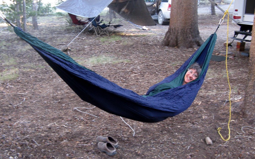
We also set up our new two-person hammock -- very comfortable and easy to use!  It was very pleasant in the late afternoons, rocking while the cool breeze blew through the trees overhead:


It's too bad that the pictures can't capture the peace and quiet of this campsite -- we were many miles away from any other people.  The only sound was the wind in the trees.  The days were generally cool and amazingly bug-free; the nights were pleasantly chilly.  After sundown, it was too cool to sit outside.  (We could not make a campfire because of the fire restrictions in the national forest; and we rarely make a fire anyway, since there is just too much risk of starting a forest fire.)  Nor can the pictures show the long, leisurely meals.  As usual, we brought our favorite foods with us -- breakfasts were eggs, salsa, and toast, and dinners were (e.g.) barbecued beef, fresh green salad, bread, and a pretty good Zinfandel.  Yes, boondocking is hard work -- all of the food and water must be carried with us, and we have to set everything up ourselves, and the terrain is rough.  But the relaxation is priceless.

Late that evening, just before bedtime, we went outside to look at the stars and were surprised to see lightning flickering up and down the eastern horizon, over the Nevada desert.  It was so far away that it was completely silent; the lightning illuminated the cloud banks over the mountains, giving them an orange glow.  Every so often, we could see the lightning bolts themselves, forking into the mountaintops.  The whole display was reminiscent of a fireworks show -- very memorable!

Monday, July 16:  We drove into Yosemite up Tioga Pass to the Spillway Lake trail, which began at around 9500 feet and ended at around 10,500 feet.  This was a surprisingly delightful trail, with a mix of shady forest interspersed with sunny meadows.  There were plenty of flowers:


Even the deer seemed to prefer the shade:


Given the altitude and the harsh conditions, we were surprised to find a tiny frog hopping along the trail: 


The lake itself was pleasant, but the lush meadows surrounded by craggy peaks were right out of “The Sound of Music:”


On our way back down to the trailhead, we had some terrific views of Mt. Conness to the north, around 12,000 feet -- it has a pretty large glacier on its north side, near the 20 Lakes Basin:


Mammoth Peak, at 12,000 feet, was just to the west of the trail – I really liked the way that the ground lupine in this swale echoed the shape of the mountain, so I had to get down on the ground to get this shot:


Felice took a shot of the same area – I looked at her camera and asked, “Where was that log in the foreground of your shot?”  Then I realized that I was the log:


Even though Indian paintbrush flowers are very common, I just had to capture this one in the late afternoon light:


That evening, we were treated to a spectacular display of lenticular clouds, which are "standing waves" of condensation: moist air flows up over the mountains, condenses, and then descends.  The area of condensation is stationary, even though the moisture continually flows through the cloud.  These clouds were south of our campsite, on the leeward side of Tioga Pass:


Tuesday, July 17: We drove up Tioga Pass to the Tuolumne Meadows area.  The trailhead to Tuolumne Falls began at Lembert Dome, which we had climbed a couple of years ago:


The trail was a bit of a disappointment – the first 3 miles were very sandy, and the pack animals had messed things up pretty badly.  But all was forgiven when we got to the falls:


Felice took one of her patented “boots” shots:

The canyon downstream beyond the falls was very enticing – Felice climbed up onto a boulder to get a better view:


But the hike was so long – about five miles each way, with almost a thousand feet of elevation gain on the return – that we could not go down the canyon any further.  It was a long, hot walk back to the trailhead.

Wednesday, July 18:   As we reluctantly left our campsite for the drive home, we got a picture of the week's collection of used bandannas, which we had hung on the awning to dry -- this is in lieu of Tibetan prayer flags, or a string of trout:

The road out of the national forest is very rough – at one point, there was a particularly deep ditch that would have given me a lot of trouble with my old trailer, and I wanted to see how much clearance we had with our "raised up" trailer.  As you can see, there is almost a foot of clearance below our plumbing, which is more than enough.  This may not seem like a big deal to most people, but to a boondocker, this is a very beautiful picture:


That night, shortly after we pulled into Lone Pine, we received a bon voyage present from Mount Whitney:

This is the same shot edited in Lightroom, a year later: