Saturday, October 20, 2012

Six Weeks in the Mountains: Part IV (Banff & Jasper)

(To enlarge a photo, just click on it; click "back" to get back.  To watch a video again, click on the counterclockwise arrow in the lower-left corner.)


September 13:  Tunnel Mountain Campground in Banff was nothing special -- just a slightly run-down RV park with indifferent landscaping, located within earshot of the railroad.  But it had full hookups and was conveniently located, so that we could recharge the batteries and shop for groceries.  After many days in remote locations, we found that Banff itself was a bit of a shock -- wall-to-wall gift shops and so forth.

During the late morning and the early afternoon, we rode our bikes along the Bow Valley Parkway.  The road was lightly traveled, the shoulders were wide, and the views were stunning: 


At one point along the parkway, we noticed a car stopped in the roadway ahead of us. We rode up to the car – the passengers pointed to the bushes alongside the road, near us. There was a large grizzly bear, calmly grazing just on the other side of the trees, probably 20 or 30 yards from us:


We suddenly realized that although the folks in the car were well-protected, our bicycles provided no protection at all.  Thankfully, the bear was completely uninterested in us.  Later that afternoon, we hiked in Johnston Canyon:


September 14:  We left Banff and pushed northward up the Icefields Parkway to Wilcox Creek Campground, at 6600 feet, overlooking the Columbia Icefield.  The drive was spectacular:


When we arrived, the campground was mostly empty (although more campers arrived later in the afternoon).  We found a campsite with an excellent view of Mt. Athabasca:


This was taken from inside the trailer, looking out of the kitchen window -- I always try to position the trailer so that there is a good view from Felice's seat at the dinette:


And, of course, we soon set up our snack area to take advantage of the view:


Just to the west of the campground, out of the forest, we could see the entire crest of the mountain:


That night, we drove down to the toe of the glacier, not far away, to look at the stars.  They seemed strange to me -- everything was out of place because we were at such a high latitude.  The Big Dipper and the North Star were high in the sky, rather than low on the horizon.

Late that night, in our cold, silent, and dark trailer, Felice heard a tiny chewing noise. I hopped out of bed, grabbed a flashlight, and yanked open the cupboard. On top of the ramen noodles sat a tiny field mouse, innocently chewing away.  It scurried away and then peeked out again, with just the tip of its pink nose showing. Although I was not happy about having a mouse in the trailer, I told Felice that was the most adorable Disney mouse I'd ever seen.  It was to become much less adorable over time.

September 15:   Perhaps because of the interruption by the mouse or because the trailer was so quiet and dark and cold, we slept until 8:30, an unprecedented event.  We hiked up to Wilcox Pass, a broad plateau of rolling hills high above the glaciers across the valley.  As we climbed, we could see the icefield spreading out below us:


Feeling adventurous, we went off-trail and hiked to the edge of the cliff facing the ice fields and then climbed up the shoulder of Wilcox Peak.  We reached an elevation of over 8300 feet:


This is the same shot, edited later in Lightroom -- the colors are more accurate:


This video gives some idea of the wind blasting off the icefield and over the cliff:


Throughout the broad plateau of the Wilcox Pass area, there were herds of bighorn sheep grazing among the rocks.  A mother and her baby posed for us on an outcropping:


They then ran down a gully to join the rest of the herd:


Throughout the afternoon, there were rain squalls and snow flurries, but nothing terribly serious – looking south down the parkway, we could see some heavier thunderstorms:


One of the most amazing things about the Wilcox Pass area was that it was so open and treeless, giving us a lot of freedom to explore off-trail:


The whole area consisted of sedimentary layers that had first been tilted from horizontal to vertical and then were later shaved off by the glaciers; the exposed edges of the layers formed a bumpy plateau:


September 16:  In the morning, we packed up and left our campsite, towing the trailer just a mile to the Toe of the Glacier trailhead, located (not surprisingly) at the toe of the Athabasca Glacier.  We climbed carefully onto the ice, staying far away from any crevasses.  The ice was not slippery because it was full of gravel:


We were fascinated by the striated rock that had so recently been exposed after the glacier had retreated.  We've seen glacially-scored rock many times, throughout the Sierra and other mountain ranges; but the scratches are usually relics of the Ice Ages, dulled by time.  Here, these rocks had been scraped within the last few years; as recently as 2000, this entire area was buried under tons of moving ice.  In this picture, Felice is holding a fragment of striated rock, next to a flattened monolith:


I then took a picture of that same bare monolith (in the foreground), looking back toward the glacier, showing that the rock had just emerged from the toe of the glacier during the last few years:


The Canadian park service had put up markers showing the speed of the glacier's retreat; here, Felice is at the "year 2000" marker:


We then headed north up the Icefields Parkway toward Jasper, stopping off at Sunwapta Falls:


A little later, we stopped at Athabasca Falls, which had carved a slot canyon:


That evening, we had no trouble finding a "no hookup" campsite at Whistlers Campground in Jasper, although the "full hookup" campsites were surprisingly busy.  As at Tunnel Mountain in Banff, this campground was not wonderful -- no views of the mountains, a fair amount of train noise, rather scraggly landscaping, and facilities in need of maintenance.  But it was the only campground open in the area during September, and it was conveniently located, and "boondocking" (camping outside a campground) is not permitted in the national parks.    

September 17:  We hiked up from the bottom of Maligne Canyon, starting at the "Sixth Bridge" trailhead, instead of starting at the top.  We were glad we did; we had the trail all to ourselves, and the river was booming past us as we headed upriver toward the slot canyon portion of the trail.  Some of the trees along the riverbank had begun to change:


The rapids were violent but lovely, creating elaborate patterns of standing waves:


After a few miles, we reached the upper canyon, the area most popular with non-hiking tourists.  There were several very graceful waterfalls:


Later that afternoon, as we drove back to Jasper, we spotted some elk on a sandbar in the Athabasca River:

And late that evening, not far from the campground, we ran across another bull elk:


Although we had enjoyed Jasper, we decided that the mountains lacked the scenic punch of the southern end of the Icefields Parkway:  since Jasper is at a lower elevation, there was little or no snow, and many fewer glaciers.  (I think we had gotten a little spoiled by the grandeur of the Columbia Icefields area!)  So we left the next morning for Lake Louise, described in Part V.

Wednesday, October 17, 2012

Six Weeks in the Mountains: Part III, Peter Lougheed Provincial Park

(To enlarge a photo, just click on it; click "back" to get back.  To watch a video again, click on the counterclockwise arrow in the lower-left corner.)

September 9:  We drove from Calgary to Peter Lougheed Provincial Park.  (For future reference, it would be fairly easy to drive straight to Peter Lougheed from Glacier National Park in a day, coming in from the south side of Highway 40, instead of coming through Calgary.)  We were hoping to get a campsite in Boulton Creek Campground because many of the sites have electricity; fortunately for us, that campground was full and we ended up in Lower Lake CG, right on the shore of Lower Kananaskis Lake, and it was virtually empty.  The campground was beautifully situated and well-maintained.  My only complaint is that the speed bumps were very high and steep and were not well-marked.  (Please don't ask me how I know this.)

After a quick lunch in the sunshine on the lakeshore, we decided that instead of setting up camp, we would take a quick bike ride on the lakeside trail to the Upper Lake.  As we rode back to the campsite, it started to get very cloudy.  We raced back to the trailer; just as we were getting back to the campsite, the rain started to come down fairly heavily. We set up camp in the rain, getting thoroughly soaked.  We ducked into the trailer just as a thunderstorm crashed over the lake. 

The contrast was comical: it was absurdly luxurious to be on the shore of a lake in the Canadian Rockies, in a thunderstorm, taking a hot shower and getting into warm, dry clothing. The trailer was rocking in the cold wind sweeping off the lake; we were sitting at the dinette, enjoying our Zinfandel and our afternoon snack.

Suddenly, the storm passed and the sun came out.  Through the trees we could see that the mountains just across the lake had received a fresh dusting of snow -- this video provides a "before and after" view:


For a long time after the storm had passed, we stood on the beach by the lake, gawking at the snowy peaks and taking pictures, watching the scene change as the clouds came and went:


Late that evening, we spotted a couple of moose in a nearby meadow:


September 10:   We awoke to a drizzly day; nevertheless, we hiked up to Rawson Lake in the rain.  We were properly dressed, but it was a bit of a hassle to hike in our ponchos.  When we got up to the lake, it started to snow fairly hard -- the sun was peeking through the clouds and back-lighting the falling snow:


This is the same shot, edited in Lightroom -- it shows the wind-driven wet snow swirling over the lake:


September 11: After a cold and drizzly night (comfortably ensconced under our heavy blankets!), we were forced out of bed early in the morning by the reflected sunrise over the Rockies across the lake, which had gotten another dusting of snow overnight.  The Rockies were to the west, and the sun was rising (obviously) in the east.  This is the first light of dawn:


A few minutes later:


This is the same shot, edited more than a year later in Lightroom -- this is much closer to the real thing:


This video provides a panorama of the sunrise:


The whole scene was so vivid (and the trailer was so close to the lakeshore) that the mountains were reflected on the side of the trailer:


Later that morning, we drove up to Highwood Pass, to hike Ptarmigan Cirque.  Near the crest, we saw this amazingly crumpled mountain, folded at a 90 degree angle in the middle.  In the middle of the saddle, the layers that would have formed the arch of the fold have been eroded away -- I think this type of formation is called an anticline:


It was still snowing lightly when we got to Highwood Pass:


The route took us up above the treeline, past an icefield, into a heavily glaciated area; we followed a spur trail high up the mountain slope:


We were right at the edge of the rain shadow of the mountains: the snow flurries were blowing in on us from the west and north, while the sun was shining on us from the south. It was cold, windy, and exhilarating to be up in this alpine environment, especially since the trailhead was at about 7500 feet.   Usually, it would have taken us many hours of slow climbing to get up to that elevation.

Down in the cirque below us, there were chaotic mounds of moraine and a remnant icefield:


That afternoon, we drove down to the Kananaskis Resort and took a bike ride along the trail through the valley. The ride trended gently uphill for several miles, through the forest. On the way back, we could see a rainstorm behind us, and we raced it back to the car.  Just as we finished loading the bikes, the storm hit.


September 12:  We were again forced out of our warm bed by another cold and brilliant sunrise over the snowy peaks:


This is the same shot, edited more than a year later in Lightroom -- this is much closer to how it really looked, including the mist on the lake and the snowy strata in the mountains:


Later that morning, we took a pleasant hike around the north shore of Upper Kananaskis Lake to the lower falls; this is the view that greeted us upon our return to the campsite:


This is the same shot, edited later in Lightroom:


We just had to take one more panorama from the campsite before leaving for Banff:


We agreed that Peter Lougheed would be worth a much longer visit, someday.  It is "only" a provincial park; in any other setting, it would be a major national park.  But we wanted to head north; so we reluctantly pulled up stakes and drove to Tunnel Mountain Campground in Banff National Park, described in Part IV.
Tuesday, October 16, 2012

Six Weeks in the Mountains: Part II, Glacier National Park (Many Glacier Area)

(To enlarge a photo, just click on it; click "back" to get back.  To watch a video again, click on the counterclockwise arrow in the lower-left corner.)

September 3:  Before we packed up to leave, the sunrise at Two Medicine forced us out of bed once again:


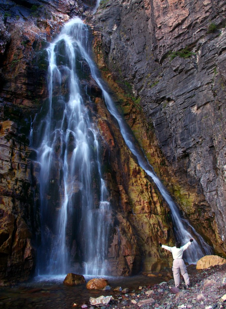
Many Glacier was an easy two-hour drive from Two Medicine.  The campground at Many Glacier was nicely shaded, but (unlike Two Medicine) the trees blocked the views of the surrounding mountains.  As soon as we had set up camp, we took a short hike to Apikuni Falls, scrambling over some rocks and boulders to get to the base -- Felice assumed her usual position of worship in front of the falls:


September 4:  We caught the 9 AM boat across Swiftcurrent Lake to the Grinnell Glacier trail. It was a fairly strenuous hike (8 miles and 1600 feet of elevation gain).  The morning started out cloudy and cool, but the clouds burned off as we climbed, revealing the deep blue-green Grinnell Lake far below us.  From different vantage points along the trail, the color of Grinnell Lake kept changing, depending on the lighting. It went from turquoise to aquamarine to emerald and back again, all day long; the extraordinary color is caused by the "glacial flour" suspended in the water, which absorbs all of the color in sunlight except for blue:


As we climbed up toward the glacier, we saw bighorn sheep grazing in a meadow below the trail:


Nearer to the glacier, above treeline, two rams perched on a rocky ledge above us:


One of them turned his head toward us, casually posing for his picture:


A busy marmot scurried amongst the rocks:


The last ascent up to the glacier itself was pretty steep, but it was worth it; the glacier tumbled down a hillside into a milky blue melt pool with a scattering of small icebergs:


We walked out onto the rocks surrounding the outlet stream -- behind us is the toe of the glacier:


As the glacier retreated, it exposed the rocks that it had sliced.  The concentric rings in this picture are cross-sections of fossil stromatolites, mats of blue-green algae formed hundreds of millions of years ago in a shallow warm ocean and then entombed in sandstone.  The layers of rock were then uplifted when the Rockies were formed and were later carved by the glacier:


This shot shows the bedding planes of the sedimentary rock, which are gently tilted, forming a shallow border for the body of the glacier:


Throughout our travels through the Rockies, we were struck not only by the height of the mountains but by the yawning space of the valleys -- all of that air between the mountains had once been rock that was slowly pulverized by the glaciers and then washed down the rivers to form the whole Mississippi Delta.  We eventually realized that the Rockies are sort of like music -- just as music requires some silence between the notes, the craggy mountains are even grander because they are separated by deep chasms.  In this view toward the south, notice the huge U-shaped valleys left by the vanished glaciers, thousands of feet thick:


This view is to the east, toward Swiftcurrent Lake and Lake Sherburne.  In the far distance, on the left side, note the curving lateral moraine, a huge tapering gravel and rock ridge deposited by the side of the glacier after the last Ice Age:


September 5:  This was our day to drive the entire length of the Going to the Sun Road, from St. Mary to Lake McDonald and back again.  The morning was gloriously clear:


On the way back from Lake McDonald, we stopped at at Logan Pass and hiked the Highline Trail for a few miles out toward Granite Park Chalet.  Although the trail was cut into the side of a cliff, there were cables strung along the rock face; we held onto them as we traversed the ledge:


Felice managed to conquer her vertigo and enjoyed the hike in spite of it:


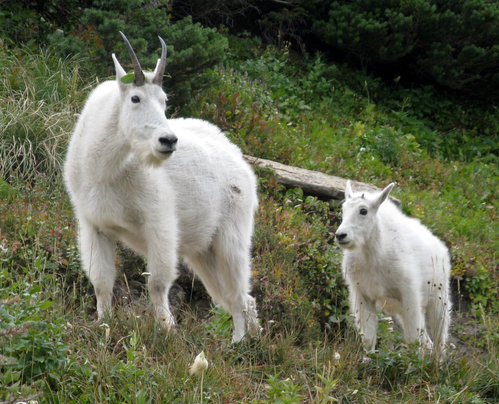
On our way back to Logan Pass, we ran into a family of mountain goats, who were completely unafraid of us, calmly grazing:


We kept backing away from the goats on the trail, but they kept coming nearer: 


Just as we got back to the parking lot, the goats obligingly walked behind the sign for Logan Pass:


Late that afternoon, on our way back to Many Glacier campground, we ran into a "bear jam" on the road; we soon discovered that there is a group of grizzly fanatics who patrol the roads in this area, lugging around their enormous lenses, hoping for the perfect photograph.  These "bear groupies" had spotted a grizzly on the beach near the lake.  The bear seemed uneasy, frequently sniffing the air for danger.  One of the "experts" told us that there was a larger grizzly in the bushes and that this middle-sized bear felt threatened:


Soon thereafter, he slowly walked into the lake and started swimming across.  Late that evening, after we were safely buttoned up inside the trailer, it rained hard for most of the night.

September 6:   We noticed that there were lots of "thimble berries" growing near our campsite – these berries are similar to raspberries.  They are very fragile and have to be picked carefully.  They are tasty, although they are full of seeds:


Since it was still cloudy after the rainstorm, we decided not to go for a "view hike" in the high country; instead, we headed back to the Going to the Sun Road, to St. Mary and Virginia Falls.  This is St. Mary Falls:


And this is Virginia Falls:


The intricate structure of the falls can be seen in this close-up:


Felice spotted these colorful rocks in a small stream near the base of Virginia Falls, and I set up my tripod for a time exposure.  That's how much of our photography works – Felice spots the shot, and I take care of the technical side:


Later that afternoon, as we headed back down to the trailhead, the clouds lifted and we could see fresh snow on the surrounding peaks.  Since the Rockies are sedimentary, the various rock layers tend to trap the snow and to display those wonderful stripes, adding extra texture to the view:


Late that afternoon, the mountains were reflected in St. Mary Lake – that's Wild Goose Island in the middle:


September 7: We hiked up toward Swiftcurrent pass, past Bullhead Lake and Red Rock Falls.  It was windy and very cool, but we found a good lunch spot on a hill overlooking the entire Swiftcurrent Valley -- again, notice the U-shaped valley carved by the glaciers, and imagine this whole valley filled almost to the brim with dense glacial ice:


We ran across several of these really striking velvety-brown butterflies, with sky-blue spots and yellow trim – after a little research, I discovered that this was the "Mourning Cloak," which is the official state butterfly of Montana:


On the way down, we found another excellent huckleberry patch and picked some more of them, all the while looking around for bears.  We devoured the berries later in the day, mixed with vanilla yogurt and granola.

September 8:  We had hoped to stay longer at Many Glacier, so that we could take the Iceberg Lake and Ptarmigan Tunnel hikes; but both of them were closed because of bear activity. So we reluctantly packed up and headed north across the US-Canadian border to an RV park west of Calgary, Alberta, for some much-needed grocery shopping, laundry, and battery-recharging (literally – the batteries were getting low after many days of "no hook up" camping).  After a recovery day, we headed west to Peter Lougheed Provincial Park, described in Part III.