Friday, July 19, 2013

Tioga and the Yosemite High Country: July 2013

We wanted to do some hiking in the Yosemite high country, near Tioga Pass, to escape the heat.  On a whim, we checked the reservation system for Tuolumne Meadows Campground, and found a last-minute opening.  On Saturday July 6, we drove to Lee Vining and stayed in the RV park at the foot of Tioga Pass.

Sunday, July 7:   We headed uphill to Tuolumne Meadows and got our campsite, which was very tight.  (We later learned that we had selected a “tent only” site for our trailer, which the Ranger didn’t tell us.  But we managed to squeeze in, anyway.)  The campground was pleasant – lots of shade and fairly cool.  As one might expect, the campground was full.  Even so, it was not too noisy, except for the occasional generator here and there.  Of course, we prefer the silence and privacy of boondocking, but the nearest boondocking is about an hour away; in prior years, we had discovered that the “commute” between our campsite and the Tioga Pass trailheads was too time-consuming, often taking an hour each way.

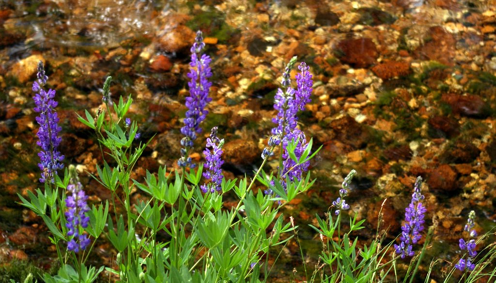
After getting settled in our campsite, we took a pleasant hike upstream along the Lyell Fork of the Tuolumne River.  Although many of the wildflowers appeared past their prime, the lupines were still going strong:


We were surprised that there was still so much water in the river, since the snowpack had been so light last winter:


Late that evening, we took a short walk.  To the south, the Milky Way over the Tuolumne River was very bright:


Lembert Dome was silhouetted by the glittering northeastern stars:


As we walked back toward the campground, a rather large bear walked out of the darkness and calmly crossed the trail right in front of us.  (It wouldn’t hold still for a photo, and I thought it might be a bad idea to use the flash.)  The next morning, we reported the bear to a ranger. She told us that this particular bear was a permanent resident in the campground area.  The bear (a female) is 33 years old, the second oldest bear in the entire country.  (Who knew that bears had birth certificates??)  This bear's teeth are worn to a nub, due to old age -- she survives by stealing easily-chewable "people food" from picnic tables.

Monday, July 8:  We hiked up Lembert Dome.  Thankfully, Felice had no problem with her acrophobia.  At almost 9500 feet, it was cool and breezy on top; the sky was so clear that it was almost indigo.  Cathedral Peak is on the left of this shot, and the Grand Canyon of the Tuolumne is on the right:


After descending Lembert Dome, we had lunch at Dog Lake and then hiked up toward Young Lakes.  The guidebook said that we would get to a great view, but we were unable to find it. However, we had a great time splashing around in Delaney Creek.

On our way back to the trailhead, we saw some climbers on the north face of Lembert Dome.  Felice looked up and said "thanks, anyway, but that's not for me:"


Tuesday, July 9:  We hiked to North Dome, which sits across from Half Dome in the upper Yosemite Valley.  The last time we took this hike, Felice had some difficulty with acrophobia, but not this time!  It was windy, cool, and clear on top of the dome:


On the way back down, we got a great view of the arch at Indian Rocks, without having to hike all the way up to it.  This is the only granite arch in Yosemite:


Wednesday, July 10:  This was a day of “bits and pieces,” rather than one long hike.  We started out at Olmsted Point, which (we thought) was just a parking lot just west of Tenaya Lake.  But we realized that there was a trail leading down from the parking area onto a ridge overlooking all of Tenaya Canyon.  The shot below is a view toward the northeast.  Polly Dome is on the left, Pywiak Dome is in the foreground on the right, and Medlicott Dome is behind it.  The high mountains in the center background are in the Mt. Conness/Saddlebag Lake area:


This view is toward the southwest, down Tenaya Canyon toward Yosemite Valley.  Cloud’s Rest is on the left, and Half Dome is above my head:
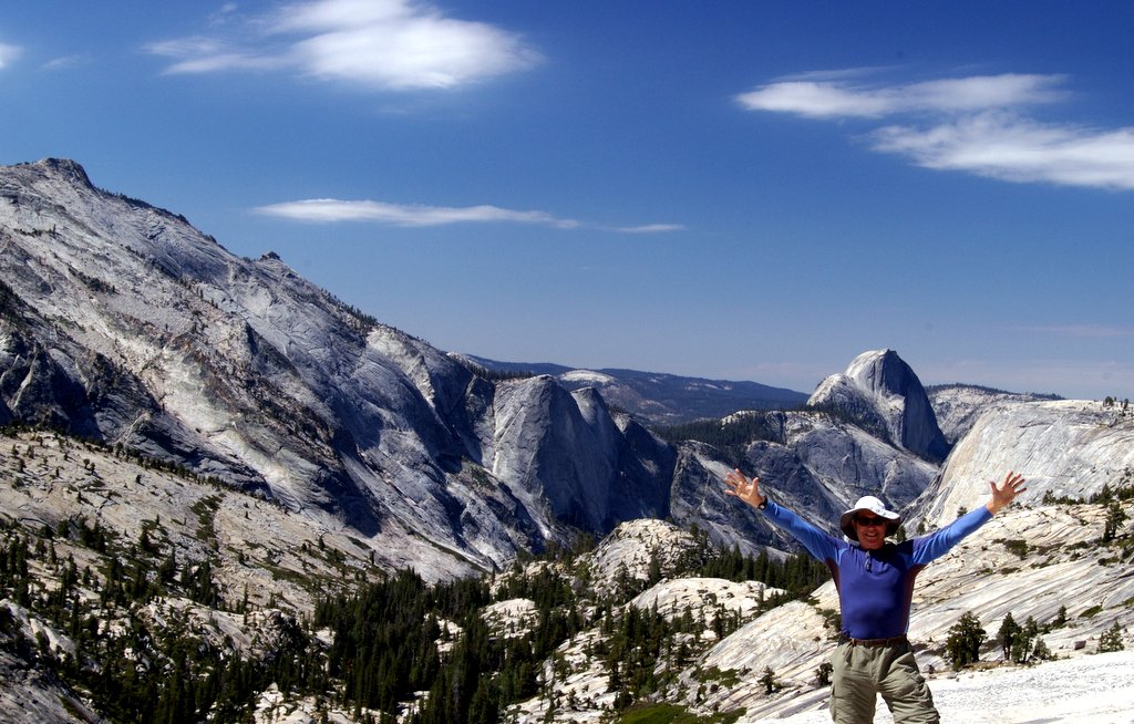


Later, we hiked up to May Lake and then had lunch on a ridge just to the east of the lake, with a sweeping view of the northeast quadrant of Yosemite.  In this shot, looking toward the east, Cathedral Peak is on the far right. Mount Dana is in the center right background.  The Tioga Crest is to the left of that, and on the far left is the Dunderberg Peak area:


In the late afternoon, we returned to the Lyell Canyon area on the Tuolumne River.  The red flowers are columbines:


The lupine stood out against the reddish gravel in the streambed:


Thursday, July 11:  We hiked up to the Cathedral Pass area.  Unfortunately, horses and mules had trashed the trail, leaving a mess and also turning the soil into loose dust.  At one point, we passed a spring, where the water gushed directly up out of the rock – in this video, the flow of the water stirs the gravel in the pool:


The trail circled around Cathedral Peak in a counterclockwise direction, beginning on the north side.  The craggy peaks dominated the entire hike; the light was continually changing, as the clouds streamed across the sky.  This is the north side of the peak:


As we got up into the high country, we saw a woodpecker flying back and forth to her nest (a hole in a dead tree), feeding her babies:


This is the west side of Cathedral Peak:


Eventually, we reached the south side of the peak:


Up at Cathedral Pass, at around 11,000 feet, it was windy and cold:


From the pass, we looked down at the Upper Cathedral Lake basin:


The shores of Lower Cathedral Lake were lined with acres of glacially-polished sheets of granite, containing inclusions of big quartz crystals that had been sheared off and buffed to a shine by the ice:


Nearby, there were unpolished examples of exactly the same sort of rock; the jagged chunks of quartz were like walnuts in fruitcake:


Friday, July 12:  We left Tuolumne Meadows and headed south to Rock Creek, between Mammoth and Bishop.  We were able to get a campsite at East Fork Campground; once again, there was no nearby boondocking.  The campsite was adequate, although there was very little shade.  Late that afternoon, we hiked up to Ruby Lake.  The lake itself was austere and bleak, but there were phenomenal views of the Little Lakes Valley from the trail:


Saturday, July 13:   We hiked the entire Little Lakes Valley, including the Gem Lakes and Morgan Pass:  


Up at the 11,000 foot level, the Indian Paintbrush was just starting to poke up:


We saw something we’d never noticed before – at the higher altitudes, the conifers were producing bright red baby cones:


Morgan Pass was bleak, austere, windy, and cool.  Back down in the meadows along the stream, the wind ruffled the grass:


Below the outlet from Long Lake, we came across a wonderful patch of flowers:


This is Felice’s view of many of my photos – I am crouched over my tripod, blocking much of the scenery:


At the end of the day, we found a shady and cool spot near Rock Creek.  We splashed around for a while and then enjoyed a cold drink next to a small rapids:


Friday, May 24, 2013

Literally Over The Rainbow: Sequoia National Forest, May, 2013

After several months without camping, we had an open week, so we (naturally) raced up to Sequoia National Forest with the trailer.  On the afternoon of May 12, we scored our favorite “boondocking” campsite, somewhere north of Big Meadow, on a ledge at 8000 feet, overlooking Kings Canyon.  This was the first time we had towed the new LMIC with the new truck on a long, rough, rutted, rocky dirt road, and we were delighted with the trailer’s clearance and the truck’s power.  (Of course, we kept our speed very low, to avoid damaging the trailer’s suspension.)

That evening at sunset, we took a walk near our campsite and came upon this terrific view of the Buck Rock Fire Lookout. Note the seemingly-flimsy catwalk bridging the gap between the two rock formations:


May 13:  We decided to explore some nearby Sequoia groves, Horseshoe Bend Grove and Kennedy Grove. They were noted on our topo maps, but these groves are not tourist destinations!  The forest roads leading to the groves was very sketchy – the sides of the new truck were deeply scratched by thorny bushes that had overgrown the old logging trail.  (I have given up on the paint job -- that’s the price of back-country exploration.)  The hike to Horseshoe Bend was very difficult and hot.  We had to “bushwhack” through the undergrowth on steep slopes, and we never did find the grove itself, even though we arrived at its alleged GPS coordinates.  (And that's the price of going off-trail -- sometimes it works out great, and sometimes not.)  It was much easier to find the northern border of Kennedy Grove – we just hiked south along the remnant of the access road to find the old-growth sequoias.

Later that hot afternoon, we drove over to Ten Mile Road and hiked up another forest road to Landslide Creek, where we splashed around in pools of cool water.  When we got back to the campsite, it had begun to cool off.  That's the snowy Monarch Divide in the northeast:


Unfortunately, the picture can't convey the silence and peace of this campsite -- the wind in the tall fir trees, the "cheeeese-burger" song of the mountain chickadee, the whizz of the bumblebees racing back and forth.  In an entire week, we saw two motorbikes near our campsite.  Other than that, nothing.  The price of this isolation was a long "commute" to other areas of the forest and the national park -- twenty minutes of slowly bumping over rocks, followed by ten minutes on a one-lane road, just to get out to Highway 198.

May 14:  We made the long drive down to the south end of the park in the Lodgepole area and hiked out to Tokopah Falls.  We were surprised (and pleased) to find that there was plenty of water in the river, even though this has been a dry year:


Felice suggested that I take a little video of the falls – she started to laugh at my bleak “just the facts” narration:


This is just another video of the falls:


That afternoon, we hiked down into Lost Grove – Felice is the small white object at the bottom center of the picture, placing her hands on the trunk of the tree and making her customary wishes:


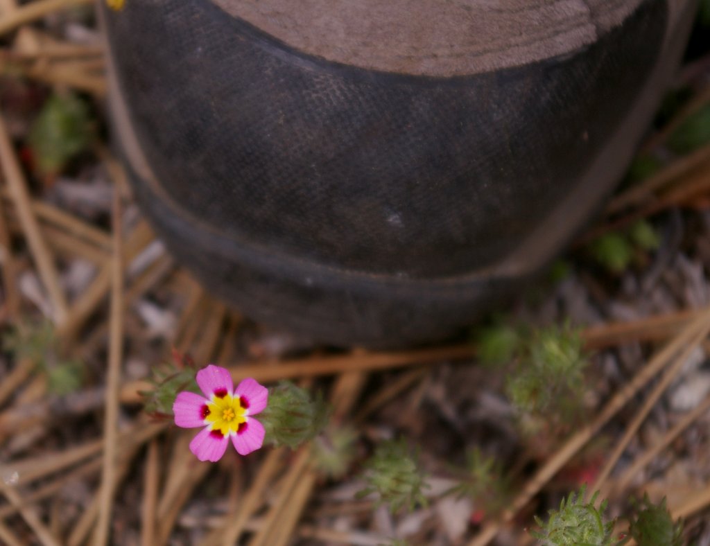
Felice’s favorite little pink flower, “True Baby Stars,” which are a type of phlox (lianthus bicolor), were scattered throughout the underbrush.  These flowers, although perfectly formed, are really tiny.  In this picture, they are next to the toe of her boot:


Late that afternoon, as we returned to the campsite, the dark clouds gathered.  We buttoned up the trailer and enjoyed cocktails and snacks in the trailer, as a cold rainstorm pattered on the roof.  Very pleasant and civilized!

The storm soon blew over.  To the west, the setting sun came out, but it was still raining hard in the deep canyon to the east of our campsite, perfect conditions for a rainbow.  The rainbow extended not only from horizon to horizon: it was a 270 degree rainbow, with the northern end dropping down into the valley below us, so that we were literally over the rainbow, looking down on the end, something we had never seen before:


The storm shifted, and the snowy mountains north of Kings Canyon slowly emerged, next to the main rainbow (and behind the fainter double rainbow):


This is the same shot, edited in Lightroom for greater accuracy:


And as if this were not enough, we were soon treated to a gaudy sunset.  The clouds to the east reflected the color of the sun setting in the west -- this is the way it really looked:


May 15: The morning was clear and cool, so we decided to take a “view hike” up to Big Baldy.  The hike was much easier than our last visit to Baldy on snowshoes!  We could clearly see the Buck Rock lookout tower, just above our campsite:


There was still plenty of snow on the Great Western Divide to the east:


Felice and I both participated in the obligatory "boot shot:"


 Felice spotted some outcroppings of metamorphic rock atop the granite ridge; this once was sedimentary rock that was then altered by heat and pressure,  It was on site prior to the rise of the granitic Sierra, which bubbled up beneath the metamorphic “country rock” and exposed it.  Note also the yellow line of pollen in the crack next to the flowers:


We were astonished by the volume of pollen streaming from the trees.  At times it looked like yellow smoke or mist.  Later that afternoon, we hiked down into Redwood Canyon and discovered that the dogwood had just come into bloom -- Felice spotted this cluster in front of the shaggy red bark of a Sequoia:


We took our usual “small person, large tree” shots.  In this shot, I am standing at the base of the tree:


And the blue speck at the bottom of this picture is Felice:


That evening, the tips of the Monarch Range caught the last of the sunlight, as lenticular ice clouds formed over the Sierra:

May 16:  The day was cloudy and cool, a perfect opportunity for the hike to Mist Falls in Kings Canyon, usually a hot 9-mile round trip.  When we got to the trailhead, we were greeted by a thin “yearling” bear:


Along the trail, we posed on a granite slab in front of the Sentinel, which seemed to have less snow than in past years:


But despite the light snowpack, the falls were booming at peak levels.  Felice felt compelled to walk into the cold mist:


This is the same shot, edited in Lightroom:


This video tracks along the main cascade:


In the middle of the falls, a huge standing wave is continuously erupting -- it is often ten feet high:


Below the standing wave, the water shoots over a smooth ledge to form a giant rooster-tail:


Late that night, I woke up and stepped outside the trailer to see the stars.  Since the moon had set, the stars were particularly brilliant and clear.  This is a 30 second time exposure with an ISO of 1600; the colors of the Milky Way are apparently real (but are invisible to the unaided eye):


May 17:  Sitting at the breakfast table in the trailer, we saw the Obelisk formation on the north wall of Kings Canyon, peeking out above a layer of low clouds:


The weather was very cool and cloudy, so we decided to hike into Muir Grove, instead of taking a “view” hike.  Dorst Campground was closed, thus adding an extra mile to the hike (but also completely eliminating the crowds!).  As we approached the grove, we stood on a granite dome and watched the clouds swirling over the ridge across the canyon and then flowing down through the trees:


Even though we’ve been to Muir Grove many times, we had never seen it in wet, cold, fog.  The trees seemed to soak up the moisture gratefully.  Bundled up against the 40 degree air, we lay down flat on our backs in the middle of a circle of giant trees, looking up for a long time as the clouds drifted through the treetops:


This is almost the same shot, edited in Lightroom:


The grove was absolutely silent – no one else was around.  Later, we hiked over to the western edge of the grove and found Felice’s favorite pair of trees, which she calls the “husband-and-wife” trees.  Unlike most paired trees, they are not joined at the base but have grown up next to each other.  In this picture, we are holding up three fingers and five fingers, since this is our 35th anniversary:


Felice is the small red object at the bottom of the picture – note the fog blowing through the top of the trees:


Before leaving, we bushwhacked into the southern portion of the grove, an area we had never explored – it was full of ancient trees, many in tight groups:


May 18:  We hated to leave our campsite, but we had to go home for a couple of days to drop off the trailer -- and, as it turned out, we were coming right back to celebrate Matt’s 28th birthday!  Before we left, Felice saluted the early morning skyline:


May 21:  Over the weekend, we decided to zoom back up to Montecito Sequoia to surprise Matt for his birthday.  We left home at 5:30 AM and were hiking near Grant Grove by 11 AM!  (The trip is a lot faster without the trailer.)  We took the Sunset Trail down to Viola Falls and Ella Falls:


Frankly, we were a little disappointed in the hike – it was hot, dusty,  and “upside down,” and the trail went through a lot of "prescribed burn" damage.  Also, the falls were rather unimpressive.  But the day was a success – we surprised Matt that evening at the lodge and celebrated his birthday at the Montecito lodge.

May 22:  The morning was cold, breezy, and clear, so we decided to tackle Mitchell Peak, a tough 2000 foot climb over roughly 3 1/2 miles, topping out at 10,300 feet, with phenomenal 360° views of the surrounding peaks.  When we got to the top, it was very cold.  We stretched out on the warm rocks, sheltered from the wind, and took a rest.  After lunch, we clambered up onto the highest rock:


On the way down from the summit, we ran into some remnant patches of snow:


That evening, there was a full moon, so we headed off to Grant Grove to walk around in the big trees.  Not surprisingly, there was no one else there – it was in the low 30s.  In this time exposure, I was able to get the Big Dipper (upside down at the top left), along with the crown of the General Grant tree (at the right):


Just before we left the grove, we caught the top half of the General Grant tree against a background of stars: