September 18: Our original plan was to head over to Mount Robson Provincial Park, which isn't far from Jasper; but after doing some research, Felice determined that there was relatively little day hiking at Mount Robson. (The backpacking is spectacular, but that's not for us.) And while examining the guidebooks, she also discovered that there is great day hiking in the Lake Louise area, which came as a surprise to me. (I used to associate Lake Louise with the Château, hardly a wilderness destination, so I didn't originally intend to go there – it turns out I was wrong!) So we packed up and headed south down the Icefields Parkway, a phenomenally beautiful drive. The leaves had changed dramatically during the last few days:


Along the way, we stopped off at Peyto Lake:


Late that afternoon, we pulled into the Lake Louise campground, which offered electricity and water and lots of train noise, day and night; but it was very conveniently located.
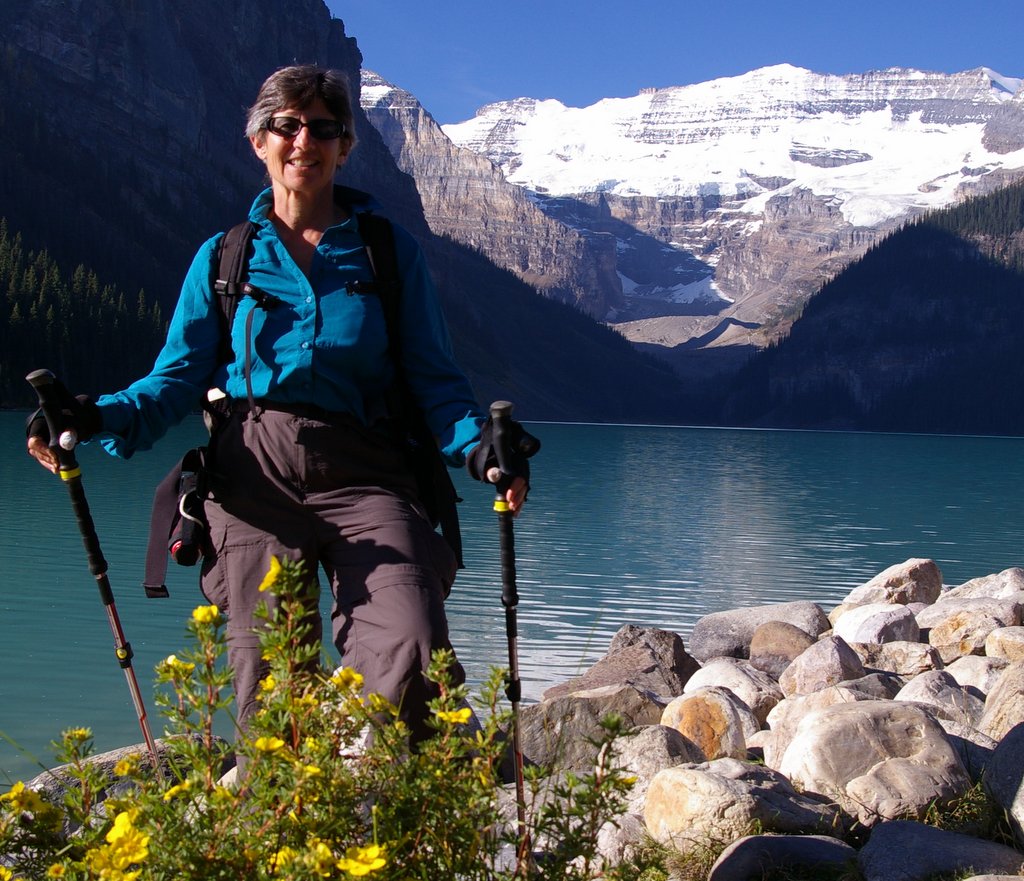
September 19: We awoke to yet another beautiful day – we were in the middle of a prolonged Canadian "Indian Summer" (or perhaps "First Nations Summer?"), with a ridge of high pressure sitting over the Rockies. (While we were enjoying cool, sunny, and breezy weather, the same huge high-pressure system was cooking Southern California with weeks of hundred degree temperatures.) As we stepped out of the trailer in the early morning, we discovered that there was a glacier-capped mountain looming over the campground – I am told it is Mt. Temple, elevation 11,600 feet:

We decided to tackle the hike to the Plain of the Six Glaciers, an 8 mile round-trip with about 1400 feet of elevation gain. As we departed from the Château, the glacier was shining across the lake:
About halfway up the trail to the glacier, we spotted a small herd of mountain goats scrambling up a ridge:


I was hoping that they would pose in front of the glacier, but this is as close as they would get -- they are in the upper right corner of the picture:

As we climbed, Victoria Glacier dominated the western horizon. The yellow tree in this picture is a larch, a deciduous conifer. (By coincidence, we had come to Lake Louise for the height of "larch season." Folks had come up from Calgary for the day, just to see the larches in full color.)

Near the top of the main valley, we could see into a big side canyon to the south, dominated by the Mitre, Mount Lefroy, and the Lefroy Glacier. Just as I got set to take a picture, we heard a huge boom as a big chunk of ice fell from the Lefroy Glacier and shattered in midair – notice the backlit cloud of ice crystals in the center of this picture:

The trail to the base of Victoria Glacier ends at an observation area, but there was a sketchy trail leading beyond it, along the edge of a ridge of moraine. We were able to get much closer to the glacier:

The trail to the base of Victoria Glacier ends at an observation area, but there was a sketchy trail leading beyond it, along the edge of a ridge of moraine. We were able to get much closer to the glacier:

From our perch, we could see down into the valley, which was partially filled with the lower portion of Victoria Glacier. Notice the crevasses running perpendicular to the axis of the glacier. The lower part of the glacier is brown, not white, because of all of the rock trapped in the ice:

In this video clip, the panorama starts in the east, with the Chateau at the far end of Lake Louise:

In this video clip, the panorama starts in the east, with the Chateau at the far end of Lake Louise:
It was windy and cold; we bundled up and perched on the rocks for quite a long time, just to watch the glacier. We had heard that there had been icefalls the prior afternoon, and we were hoping to see one. The edge of the upper glacier was teetering on the edge of a cliff; the annual layers of ice within the glacier are clearly visible:

The waiting paid off: we were lucky enough to see an icefall. Our first warning was the thunder of the ice cracking off from the main glacier. This sequence shows the progression of the icefall – the ice is falling from Victoria Glacier onto the toe of Abbott Glacier, which is on the left side of the picture:

The waiting paid off: we were lucky enough to see an icefall. Our first warning was the thunder of the ice cracking off from the main glacier. This sequence shows the progression of the icefall – the ice is falling from Victoria Glacier onto the toe of Abbott Glacier, which is on the left side of the picture:


Although we were too far from this particular icefall to see its residue, there were several other avalanche chutes nearby, with angular chunks of fresh-fallen ice spilled onto the lower glacier:


Later that afternoon, on our way back down, I couldn't resist another shot of the Mitre framed by a larch:

As we got back down toward Lake Louise, we noticed that the stream running from the glacier into the lake was not blue – it was milky white, looking exactly like runoff from a sloppily-maintained concrete mixer:

And yet, when that milky water ran into the lake, it became turquoise blue:

Late that evening, after the campground was completely dark, a little bit of the sunset still lingered on the edge of the glacier at the top of the mountain:

September 20: Since it was "larch season," we felt compelled to try the Larch Valley/Sentinel Pass hike, a strenuous round-trip of 8 miles with an elevation gain of 2500 feet, topping out at about 8400 feet. The first couple of miles were through the forest, until we got to Larch Valley:


After leaving Larch Valley, the trail was mostly above treeline. Near the pass, we could see that it was a series of daunting switchbacks carved into the walls of the cirque -- and yes, the faint scratches on the cliff behind me are the switchbacks:

Parts of it were fairly narrow, exposed, and crumbly, but Felice was again able to overcome her vertigo:

The view from the top was our reward:

This picture looks north toward the Lefroy Glacier – the day before, we had been looking south toward that same glacier from the trail to Victoria Glacier. The backside of the Mitre is on the right:

On the way back down, we caught the reflection of Fay Glacier in a small pond:

The larches provided a convenient frame for Fay Glacier:

This area is known as the "Valley of the Ten Peaks;" most of the peaks appear in this short video clip:
September 21: We decided to move to Yoho National Park, just a half-hour to the west, on the other side of the Continental Divide. (We didn't want to have to "commute" to Yoho from Lake Louise, and we wanted to escape the train horns during the night at the Lake Louise campground.) We were able to get a really great campsite at Kicking Horse Campground, right on the riverbank. The roar of the rapids helped to mask the sound of the trains. (Many of the campgrounds in the Canadian national parks in the Rockies are near the train tracks, probably because the railroads were largely responsible for developing the parks.) That afternoon, we stopped off at Natural Bridges, just down the river from the campground:

We then took a pleasant bike ride on a gentle singletrack trail along the river – it was completely deserted:

The river was loaded with "glacial flour," fine powder scoured out by the glaciers. Depending on the angle of the sunlight, the river was milky blue or milk white:

As we returned to our campsite late that afternoon, Mt. Stephen loomed over us, illuminated by the slanting sunlight:

September 22: We took a long hike (10 miles round-trip) to Twin Falls on a hazy day – there was a fair amount of smoke in the air from forest fires to the south. We stopped for lunch at the base of Laughing Falls:

Most of the trail was flat, with a steep climb during the last mile or so to Twin Falls:

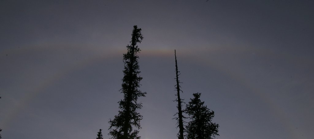
We were not sure if the hazy sky was due to smoke or due to moisture – later that afternoon, we saw an unusual "sun dog" or parhelion, with a rainbow around the sun and another rainbow intersecting it at a tangent. I think these are caused by ice crystals at high altitudes refracting the sunlight:
Back at the trailhead, we were surprised (and delighted) to find that there was enough sunshine, despite the haze, to create a rainbow across Takakkaw Falls, the highest waterfall in Canada (over a thousand feet):

September 23: Despite the hazy conditions, we hiked the Iceline Trail, more than 8 miles round-trip and about 2000 feet of elevation gain. The trail began very steeply; after quite a while, the trail emerged from the trees, giving us a view of Takakkaw Falls, with Daly Glacier (its source) above it:

Once we got above treeline, the mountains opened up all around us:
The trail skirted the base of Emerald Glacier; the tip of Felice’s pole is pointing to the annual layers of ice:

The glacier had recently retreated, revealing a worn-down staircase of sedimentary rock:

In the far distance, we could see the huge Wapta Icefield. The middle of the main glacier is striped with a curving "medial moraine," where two or more tributary glaciers have come together. The lateral moraines (on the sides of the two tributaries) then merged to form the medial stripe:

At the trail’s summit, Felice clambered up a rocky peak overlooking the whole valley:

After we got back down to the trailhead in the late afternoon, we took another short walk to Takakkaw Falls – I couldn't resist another "rainbow time exposure:"

As we drove back down toward the campground, we noticed a group of cars gathered at the "spiral tunnel overlook." Because the mountains in this area are so steep, the Canadian railroad had to dig two huge spiral tunnels to help the trains cope with the difficult grade. This is the "upper spiral" – the cars in this picture all belong to the same train, and the middle half of the train is inside the tunnel. The cars on the right side of the picture are moving west, into the tunnel -- the cars on the left, slightly lower down, are moving east, out of the tunnel:


That evening, near the campground, we spotted another bull elk:


September 24: In an effort to escape the smoky skies (and to begin our trek back home), we drove for 11 hours from Yoho to Bellingham. It was a big effort, but it was worthwhile because it gave us an extra day in the Mount Baker area, described in Part VI.
No comments:
Post a Comment