(Remember that you can
click on the photos to see a slideshow, and then hit "escape" to get
back to the text. Also, a note on the photo credits: as always, both Felice and
I took these shots, and many of my shots resulted from her suggestions. I do the photo editing using Lightroom; my
goal is to reproduce just what we saw, as faithfully as possible.)
Tuesday, August 22: As
we headed from Fruitland, Idaho, toward Washington, we were trying to figure
out where to go next, since so much of the Far West (and especially the Pacific
Northwest) was covered in smoke. We
decided to hold off on heading north to Mount Baker, since we had heard that
smoke from the British Columbia fires had spilled over into northwestern
Washington.
The real-time "smoke maps" available to us on the
web showed that Mount Rainier looked fairly clear, at least for the time
being. (Hurrah for unlimited data, and
hurrah for Felice’s ability to use her iPhone to gather information while we
were on the road!) The route across
northeastern Oregon was dismal – barren rolling hills, shrouded in orange
smoke. We drove to Columbia Sun RV Park
in Kennewick, Washington. It was huge
and well-appointed. Our trailer was less than half the size of any other rig in the park -- we looked out of place.
Wednesday, August 23: We drove from Kennewick toward Mount
Rainier, thinking we would stop late in the day to see if we might be able to
find a spot at White River Campground, which has quite a few "first-come,
first-served" spaces. (Our backup plan was to camp in a nearby forest service campground.) Miraculously,
we found a good space in D loop, although not one of the prime spots right on
the riverbank.
Thursday, August 24:
We took the Glacier View trail, which starts right in the campground. The morning clouds were lifting away from
Little Tahoma, a volcanic peak east of Rainier:


We stopped for lunch where the trail intersected the White
River, with an impressive boulder field:

At the high point of the trail, we found some pasqueflowers
in bloom, aka the Lorax blossoms:

We went back down the trail to a spur leading to the Emmons
Moraine, which gave us great views of the snout of Emmons Glacier -- Felice's pole is pointed at the terminus:

This is a close-up of the crevasse field high on the
mountain. As the river of ice flows very gradually (perhaps, dare I say, glacially?) up and over resistant
ridges of rock, it fractures into huge parallel blocks. These are slow-motion rapids, a newly-minted oxymoron:


That evening, just at sunset, we stood on the edge of the cliff overlooking
the White River to watch the new moon setting over the peak of the mountain:


This was also taken from the cliff over the river, much
later that evening:

Friday, August 25: We
drove up to the Sunrise trailhead to take the Burroughs Mountain Trail, one of
the greatest hikes we've ever taken. The massive rounded peak of Rainier was in our faces all day long. It was overwhelming, sort of like sitting
very close to an Imax screen. We took
the loop trail in a clockwise direction, which was wonderful – every
switchback brought the view closer and closer:


Felice took this picture of the peak from the high point of
the trail – it wasn't until we got home and looked carefully at the center of the picture
that we saw the slanting climbers’ traverse cutting diagonally across the north
face of the glacier:

From the top, we got a great view of the steamy volcanic area on the north side of the peak. The thick layers of successive lava flows are visible in the foreground:

After the hike (and some soft-serve ice cream), we drove
down the hill a little way to Sunrise Point, where we knew we could get a cell
signal (so we could check the weather forecast and our email). We parked in a far corner of the parking lot,
in the shade. When we were ready to go,
I turned the ignition key – nothing. The
battery had died, without any warning.
As we were discussing our meager options (we were 60 miles
away from the nearest tow truck), a person emerged from a nearby camper. "Dead battery? Let me give you a jump!" He introduced himself as Sierra Willoughby, a
former Rainier ranger. He recommended
that we drive immediately to Enumclaw and get a new battery. (As it turned out, Mr. Willoughby was camped not far from us; we brought him home a sixpack of Sierra Nevada Hop Hunter IPA, his favorite.)
That's exactly what we did – fortunately, the O'Reilly auto
parts store was open late. To celebrate,
we got a pizza and managed to watch the Dodger game on Felice’ iPhone – quite a
treat! That win was the end of the Dodgers' record-setting hot streak; their record-setting losing streak began the next day.
Saturday, August 26: The day was very hot and hazy. Instead
of undertaking a demanding hike, we took the easy Eastside Trail along Chinook Creek
to Stafford Falls:

Nearby, we found a very secluded swimming hole – we bravely
submerged ourselves in the snowmelt, just as the timer clicked the shutter:

Sunday, August 27: We
took the Summerland hike, which was shady and cool most of the way. This group of "shelf fungus" or
"bracket fungus” was pretty impressive – each of those "shelves"
is about the size of a dinner plate.
Believe it or not, some forms of this fungus our edible – no, thank you!

Up top in Summerland, the monkeyflowers were lining the
creeks. In this shot, you can see a
little bit of haze near the peak from the wildfires throughout the Northwest. The lower elevations
were much smokier:


There were some clumps of (I think) mountain bog gentian in
the meadows -- these were the most beautiful flowers that we saw on this entire
trip:


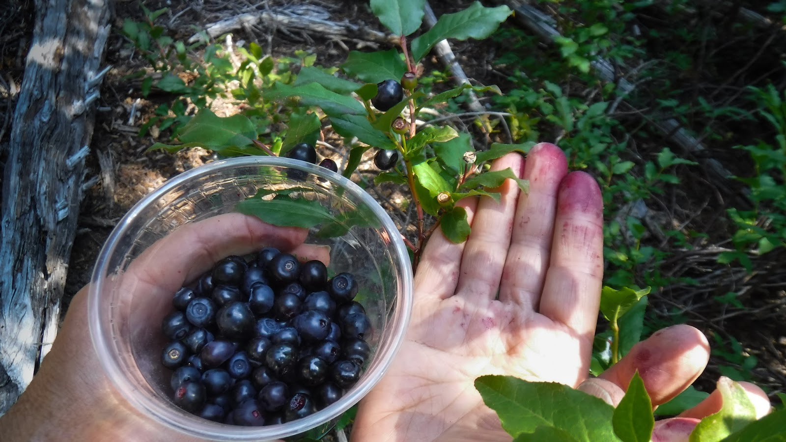
On our way down, we stopped off to pick about a quart of wild
huckleberries, which took us almost an hour. We mixed huckleberries into yogurt and ice
cream for the next week – delicious!
That night, we took a long exposure of the mountain, just
after the moon had set behind the peak:

Monday, August 28: When
we woke up, it was pretty smoky. So we
ditched our plan to move to Cougar Peak Campground and instead headed south to
try to find clear skies. But Oregon was even
worse – 100° temperatures at the coast, with very bad air quality throughout
the state, and no relief in sight. We
stopped for the night at an RV park in Crescent, Oregon, north of Klamath Falls. During our drive through all of Oregon, we never saw one speck of blue sky -- just brown and orange smoke.
Next: Part III – Tahoe
and the Desolation Wilderness
-->
1 comment:
What a grand adventure at Mount Rainier! Those were some very nice hikes you took. And, some very nice photography! It is such a treat to see your love of the outdoors. Thanks again for sharing your trips!
Post a Comment