Saturday, October 20, 2018

The Mountain West, Fall 2018: Part 3 (Crested Butte)

(Click on the photos to see a slideshow; hit "escape" to get back to the text.  As always, both Felice and I took these photos.  I edit them on Lightroom, trying to reproduce just what we saw.)

Sept. 20:  We drove from Fruita through Montrose and Gunnison to Crested Butte, just over 160 miles, an easy drive.  Using Google Earth and the Forest Service Motor Vehicle Use Maps, I had spotted a bunch of decent boondocking sites in the canyons not too far north of Crested Butte.

This time, we did not unhitch the trailer -- Google Earth had shown me that there were a few wide turnaround areas in the canyon.  We cruised slowly up Washington Gulch, which was a relatively smooth gravel road (at least in the lower reaches of the valley).  We were surprised (and not pleasantly) to see so many RVs parked in the meadows on an early Thursday afternoon in mid-September.  Fortunately, the spot that I had hoped to get was in the upper part of the canyon, where the road was narrow and rough, not suitable for most RVs (except truck campers).  And yes, the spot was still open!

The muddy "driveway" up to our campsite was very steep -- probably the steepest unpaved grade I had ever towed on.  (Please excuse the preposition at the end of the sentence -- this is a very exciting story.)  I had to put the truck into "Four Wheel Low" (a rare event, prior to this trip) and crept up the hill.  The truck did not lose traction, but I had to give it a lot of gas to make any progress at all.  (End of exciting story -- I guess you had to be there.)

At the top of the access road, the campsite per se was very spacious (which, as we will see later, is not always a good thing):


There was no view of the canyon from the site because of all the doggone trees, but the trees themselves were pretty good:


Late that afternoon, a polite young guy pulled his car onto the lower portion of our "driveway" and told us that "about 20 of his friends and family members" would be joining him that weekend.  We were not happy to have neighbors, but it's a free country, so (to quote Tony Soprano), "Whaddaya gonna do?"

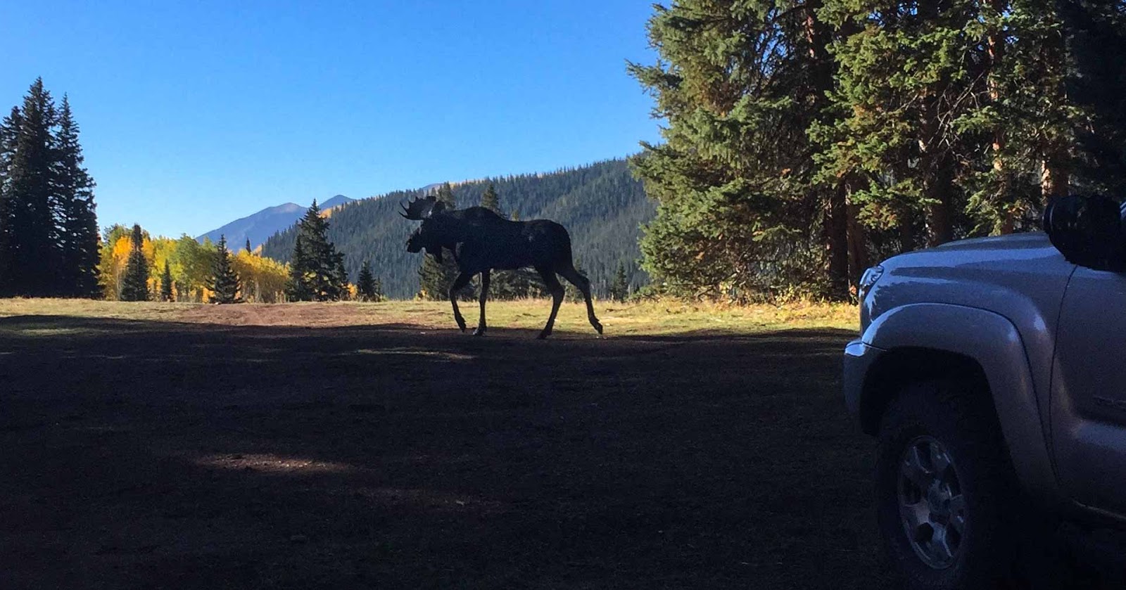
Sept. 21:  Just after breakfast, Felice went to get something out of the truck.  Something was coming out of the trees, just a few feet away from the trailer -- a fairly large bull moose!  She called to me and (showing great presence of mind) snapped a couple of photos with her iPhone:


After the excitement of the moose wore off, we finished our coffee:


This is not a trick shot -- that is a reflection in the window:


 We headed back into town to do a few errands but were waylaid by Gothic Mountain:


That afternoon, we had time for a short hike in the upper part of Washington Gulch.  The trailhead was at around 11,000 feet; we hiked for about four miles (round trip).  The road up to the trailhead was not too rough, but there was one hairpin curve that was too tight for a long wheelbase truck, so we had to do a three-point turn.  That was something I had never encountered.

From the trail, we could see into the Slate River canyon, otherwise known as the "Oh-Be-Joyful" area (great name!):


The trail leading from Washington Gulch over to the Gothic Valley looked down on the town of Crested Butte:


The geology of the Gothic Valley was complex -- the strata ran every which way:


Sept. 22:  We headed out toward Kebler Pass on Route 12, a surprisingly-busy gravel road, to Horse Ranch Park, and took the Gold Creek trail.  We hiked around 7 miles, round trip, with less than a thousand feet of elevation gain.

Not far from the trailhead, we came across an aspen grove under attack by some ambitious beavers.  At first, we could not figure out why they would cut down so many large aspens and then just abandon the trunks, wasting all of that effort:


But a close look at a nearby pond cleared up the mystery -- they cut down the trees so that they could get to the branches to build their lodges and their dams.  Note that the leaves on these branches are still fresh and green -- very recently cut!


All along the trail, there were good views through the trees -- this is East Beckwith Mountain, I think:


According to our guidebooks, the aspen groves in this area are some of the largest in North America:


The trail passed through the Raggeds Wilderness (not ragged):


I am pretty sure that the arched peak is Marcellina Mountain, on the left side of this photo.  Geology aficionados (and aren't we all?) will of course recognize it as a classic laccolith, where a blob of magma rose under the base of the mountain, caused the overlying strata to bow:


(Just to be clear, I did not know that until I looked it up.)

The aspens were so bright and so dense that the air looked like light green water.  We took a super slo-mo movie:


On our way back to our campsite, we came across my favorite road sign:


Back in town, we noticed a lot of activity.  It turns out that this was the local celebration of Vinotok, a pagan harvest holiday, complete with a bonfire and a parade.  Felice got so excited that the end of the video has the marchers going straight up:


It was too chilly to have cocktail time outside, but we could still see the late afternoon sun on the aspens:


That evening, we discovered that in addition to the promised "20 friends," a new group arrived, about 50 kids from town, with little tents dotted all around us.  Not too close, but still annoying.  They all went down to town to participate in the Vinotok festivities and then came back late at night.  Fortunately, they were not too noisy, and they were all gone by the middle of the next morning.  Most astonishingly, they did not leave one speck of trash --  a miracle!

Sept. 23:  We often have multiple guidebooks for any given area -- sometimes, one author will describe a hike that the others have omitted.  This was one of those instances -- one of the books mentioned a newly-opened trail to the North Pole Basin, which was not open to the public until around 2013.  It sounded good, and it was great.

We headed up through the Gothic area to the trailhead (just north of Schofield Pass).  The guidebook warned us that the access road from Schofield Pass to the North Pole trailhead would be tricky, and it was -- very narrow, very rough, cut into the side of a significant cliff.  Much more suitable for a little Jeep than a full-size truck. 

We crawled along very slowly and carefully.  Big bulging ridges of bedrock caused the truck to lean over sideways toward the edge of the cliff.  I was not alarmed, but I was fully alert (and having fun, in a cautious way).  At one particularly challenging place, Felice threatened to jump out and walk.  (She didn't, at least not this time.)  I asked her to take a video of the truck inching over the really interesting boulders, but she did not think that this would be a good idea. 

Fortunately, when we got to the trailhead, there was a small flat space available for parking.  We were the only vehicle at the trailhead (always a good sign!), although later in the day two more vehicles arrived.  (Most of the trail is on land belonging to the Rocky Mountain Biological Laboratory.)

The first part of the trail was pleasant but unremarkable, winding upward through the forest.  At one point, we came across an abandoned wooden hot tub, so I climbed in:


(It turns out that this hot tub belonged to a defunct resort, which is now part of the RMBL property.)

Eventually, the trail breaks out of the trees and begins a fairly steep climb up an old mining road.  As we climbed, the south side of the Maroon Bells came into view:


The upper portion of the trail was above treeline, with sweeping views of the surrounding peaks:


This shot provides an even better view of the Maroon Bells, in the center of the photo.  For most of the day, we were completely alone in this chilly and breezy basin, at nearly 13,000 feet:


Felice is looking up at the uptilted strata of Crystal Peak:


Usually, our pictures come reasonably close to capturing the feeling of the places we go.  These really don't -- there is no way to catch the huge, open, silent expanse of this wild area.  This was among our favorite hikes of the whole month-long trip.  (For the record, we hiked about 7 miles round trip, with about 1500 feet of vertical gain.)

Sept. 24:  After breakfast, it looked like it was going to rain; being hardy Californians, we just hitched up and fled, heading down to Montrose for some errands, and then on to Silverton.  As we left Washington Gulch, we stopped for one last view of Gothic Peak:


Next:  Part 4 (Silverton)

Thursday, October 18, 2018

The Mountain West, Fall 2018: Part 2 (The Tetons)

(Click on the photos to see a slideshow; hit "escape" to get back to the text.  As always, both Felice and I took these photos.  I edit them on Lightroom, trying to reproduce just what we saw.)

Sept. 13:  We drove into Jackson and stopped at the Bridger National Forest office to buy some maps and get some tips on hikes in the area.  The staff gave us some great advice on boondocking -- I had planned to camp in the forest above Curtis Canyon (near the Elk Preserve), but the ranger told us that the road had been badly damaged by off-road trucks after a recent rainstorm and was virtually impassable.  He suggested instead that we check out another area up toward Moran Junction, near the Triangle X ranch.

We unhitched the trailer at a highway turnout near the ranch and went exploring in the unencumbered truck -- this is one of the most enjoyable aspects of boondocking, cruising around on the back roads, looking for the best available site.  The access road was pretty rough (deep ruts, big rocks, and steep hills), but we were sure that the trailer would be able to handle the terrain (yes, at 3 mph, but that's good enough!).

We first came across a big flat meadow, up on a ridge, with a panoramic view of the Tetons and the Snake River Valley:


Heaven, right??  Nope -- the meadow was covered in wall-to-wall noisy big rigs.  No good.  So we kept crawling along, checking out each of the spur roads branching off from the main route.  This one had no view; that one was too dusty; the third was not sufficiently private.

After about an hour of searching, we found a great site:  a good (but not great) view of the mountains, quiet, secluded, grassy, with room for just one trailer (no neighbors).  The only problem was a deep dip (really a seasonal streambed) -- could the trailer handle this challenge without bottoming out?  We went back down to the highway, hitched up the trailer, and slowly crossed the Big Dip -- success!  This photo does not show the depth of the streambed, but let's pretend that it does:


The campsite had one other minor flaw:  although it was a "lollipop" site (with just enough room in the cul de sac to turn the trailer around), there was a young aspen tree slanted across the "driveway," perfectly poised to collide with the air conditioner on the roof of the trailer.  (It is illegal in most national forests to cut a live tree without a permit.)  But no problem!  I had brought my extendable 10 foot pole (formerly a drywall lifting pole) for exactly this reason.  I lifted the tree while Felice drove under the obstacle:


With apologies to Grant Wood's "American Gothic," this photo shows the business end of the contraption -- I attached two long quarter-inch bolts through a small piece of  plywood and then screwed the plywood onto the end of the pole:


Go ahead and laugh -- it worked!!

Sept. 14:  We took the Bradley and Taggart Lakes trail, which was pleasant but not very taxing (mostly level and relatively short).   The Tetons loomed over us throughout the day:


Felice took this photo on her iPhone -- she held the phone down in the meadow grass (for foreground interest) and tilted the lens up at the mountains:


Late that afternoon, back at the campsite, it was warm enough to convene our traditional "snacking circle:"


The sunset that evening was better than average -- during most of the month of travel, there were not many great sunsets, because the sky was too clear and there were no clouds to catch the light.  (Life can be so hard, sometimes.)


Sept. 15:  On our way to the trailhead, we stopped off at Jackson Lake Dam to catch the reflection while the lake was still calm:


We took the Leigh Lake/String Lake trail -- again, not very demanding, but with great views:


At the end of the day, our feet were grateful for the snowmelt:


Sept. 16:  We started out on the Garnet Canyon trail but were persuaded by fellow hikers to try the Amphitheater Lake trail.  It was a very instructive day:  we learned that a ten mile round-trip hike with three thousand feet of vertical gain can be more of an ordeal than a pleasure, unless the destination is really extraordinary.  And to tell the truth, the lake was not extraordinary -- it was just a nice glacial cirque:


The trail surface was rocky and steep, and there were quite a few people.  Not a bad day, but not one of our best hikes ever.

By the way, you can just see in that photo that Felice is carrying a red canister of bear spray on her belt.  The rangers advised us to have spray handy at all times.  Another hiker on this trail told us that a guide and a bow-hunter had just been attacked by grizzlies in the national forest.  We later found out that the attack took place just a few miles from our campsite, when the hunter and the guide had gone back to look for an elk that they had wounded the previous day. 

Sept. 17:  This was a day of errands in Jackson -- laundry, shopping, work, etc.  No photos of the laundry, although the name of the laundromat was Missing Sock Laundry -- well played! 

Sept. 18:  Forcing us out of a warm bed (grumble), the Tetons reflected the sunrise:
  
We took the Cascade Canyon trail, starting with a ferry ride at Jenny Lake that saved us a couple of miles of walking.  We covered about nine miles and gained over 1000 feet.  The trail was fairly busy, but for good reason:

  
(Those berries are evidently inedible -- there were huckleberry bushes all along the trail, but the bears had harvested all of the fruit.  They would not touch those reddish-orange berries, though.)

We spotted a female moose basking in the morning sun:


 This is a wide shot of the same scene, showing the breadth of the canyon.  The moose is at the bottom of the photo, left of center:


Felice managed to snag a shot of the elusive pika:


These adorable little critters not only look like stuffed animals, they even sound like squeaky toys -- cheep! cheep!

All along the trail, the foliage was changing color:


Another group of hikers spotted this bear on the wall of the canyon, high above us.  It looks close due to the telephoto lens, but it was probably a hundred yards away.  I think it was a grizzly, judging by the ears and its size, but I am not sure:


Later in the day, we spotted a bull moose, but he was hidden in the shadows and was too far away for a decent photo.

Sept. 19:  We woke up to a very smoky day -- the mountains were barely visible from our campsite.  A forest fire had broken out southeast of Jackson.  So we pulled up stakes and headed to Colorado, stopping for the night in Fruita (another 450 mile day).  The route took us through Flaming Gorge in Utah and then through Rangely, Colorado.  I had heard that the road from Rangely to Fruita was bad, but it wasn't -- decent pavement, not too steep or twisty, and wonderfully empty.  (Perhaps my recollection is influenced by the fact that Felice bought a pint of Ben and Jerry's ice cream in Rangely and then slowly spooned it into my mouth as we drove south in the late afternoon -- very pleasant!)

Next:  Part 3 (Crested Butte).

Wednesday, October 17, 2018

The Mountain West, Fall 2018: Part 1 (Great Basin National Park)

(Click on the photos to see a slideshow; hit "escape" to get back to the text.  As always, both Felice and I took these photos.  I edit them on Lightroom, trying to reproduce just what we saw.)

The original plan for this autumn was a trip to the Northwest and British Columbia, both of which unfortunately caught fire.  But in late August, we studied the daily online air pollution maps and noticed that much of the smoke coming from the West seemed to be arching up over the Tetons, with the flow of the jet stream; Colorado and Utah were clear, too.  The various webcams looked good, so hurrah for Plan B!

Our first destination was Great Basin National Park, since it was sort of on the way to the Tetons.  The big goal on our first day (Sept. 9) was an RV park in tiny Pioche, Nevada, 450 miles from home, a long day of driving.  But surprise!  We had a strong tailwind most of the day (which makes a big difference when towing a trailer), and we got to Pioche in the afternoon.  It was hot.  Stop, or keep going?  We knew there were no other RV parks along the route, but maybe we could get to a campground in the evening, using our trusty headlamps to set up camp in the dark . . . .

We just kept barreling north on Highway 93, through the scenic but desolate high desert.  Northern Nevada is not like the area around Las Vegas -- it is mountainous, with chaparral on the hillsides.  The road was empty:  just the way I like it.  To alleviate her usual "trapped in the passenger seat" restlessness, Felice tried out a NASA-style bungee workout cord that I had improvised.  (The verdict: not wonderful, but better than nothing.) As we approached Great Basin, Felice pored over the map and discovered a BLM campground, Sacramento Pass, perfectly located on Highway 50.

We stopped around sunset (550 miles -- a new daily record for us!) and set up camp, and yes, the headlamps were successfully deployed.  For future reference, the campsites nearer to the highway have a little more road noise (not surprisingly).  There is an interior loop up a steep roadway, called the Equestrian Area, that is farther from the highway (but which seemed crowded for a Sunday night in September).

That night, the Milky Way display was one of the best we have ever seen -- the bright "star" on the left is actually a planet, Mars.  The photo does not do justice to the deep rust color of Mars; on the other hand, the photo slightly exaggerates the beauty of the Milky Way, so it comes out even:


As it turned out, the view of the Milky Way was better from Sacramento Pass than from Wheeler Peak Campground in Great Basin:  since the horizon to the south was not blocked by the mountains, the bright center of the galaxy was fully visible.  (Those are high, thin clouds just to the right of the galactic center, not part of the Milky Way itself.)

Sept. 10:  This was a bonus day -- we were supposed to be in transit, but our marathon drive to Sacramento Pass meant that we were able to get to Lehman Caves for the morning tour.  The tour was interesting -- the guide knew quite a bit about the local geology, and the formations were satisfyingly grotesque.  Amazingly, these shots were all taken on Felice's iPhone -- none of our other cameras worked well in the dim lighting:


There was even some wildlife -- this little guy is a pseudo-scorpion, about an inch long:


After the cave tour, we headed up the hill to Wheeler Peak Campground, at around 10,000 feet.  The road to the campground is steep and twisty, but a good tow vehicle would have no trouble pulling a small trailer up that grade.  The interior roads in the campground were pretty tight but not impossible.

The views of the ridge from some of the campsites were excellent:


Our campsite was in the trees, but we could still see the mountains from our front window:


As you might expect at 10,000 feet, the stars were terrific, even if the nearby peaks cut off part of the Milky Way:


Sept. 11:  We had already acclimated to the elevation for a couple of nights, so why not tackle the Wheeler Peak trail?  The last time we tried (almost exactly two years ago), the snow and ice and howling wind stopped us about halfway up.

All along the trail, the aspens were at peak color:


There was no snow, which made the footing a lot easier, even if the dry mountains were a little less scenic:


Up on the ridge at well over 12,000 feet, the wind was (once again) howling --  my guess is that it was above 40 knots, not quite as bad as the last time we were here.  We were so high up that the sky was a very dark blue:


I tried to narrate a short video, describing the view into Utah and much of Northern Nevada, but the wind blasted the microphone:


Felice did her best Rocky the Flying Squirrel imitation:


We were within a thousand feet of the peak when we had to turn back -- I am not sure we will ever make it to the top of this mountain.  (For the record, we climbed well over 2,000 vertical feet and hiked more than 8 miles.)  On the way back down to the trailhead, the aspens were backlit by the afternoon sunlight:


Sept. 12:  We hitched up and headed out of the campground through a tunnel of aspens:


We headed northeast through northern Utah and Wyoming toward the Tetons, stopping for the night in Thayne, Wyoming, a 430 mile day.  Not an epic drive, but plenty long.

Next:  Part 2 (The Tetons).