This time, we did not unhitch the trailer -- Google Earth had shown me that there were a few wide turnaround areas in the canyon. We cruised slowly up Washington Gulch, which was a relatively smooth gravel road (at least in the lower reaches of the valley). We were surprised (and not pleasantly) to see so many RVs parked in the meadows on an early Thursday afternoon in mid-September. Fortunately, the spot that I had hoped to get was in the upper part of the canyon, where the road was narrow and rough, not suitable for most RVs (except truck campers). And yes, the spot was still open!
The muddy "driveway" up to our campsite was very steep -- probably the steepest unpaved grade I had ever towed on. (Please excuse the preposition at the end of the sentence -- this is a very exciting story.) I had to put the truck into "Four Wheel Low" (a rare event, prior to this trip) and crept up the hill. The truck did not lose traction, but I had to give it a lot of gas to make any progress at all. (End of exciting story -- I guess you had to be there.)
At the top of the access road, the campsite per se was very spacious (which, as we will see later, is not always a good thing):

There was no view of the canyon from the site because of all the doggone trees, but the trees themselves were pretty good:

Late that afternoon, a polite young guy pulled his car onto the lower portion of our "driveway" and told us that "about 20 of his friends and family members" would be joining him that weekend. We were not happy to have neighbors, but it's a free country, so (to quote Tony Soprano), "Whaddaya gonna do?"
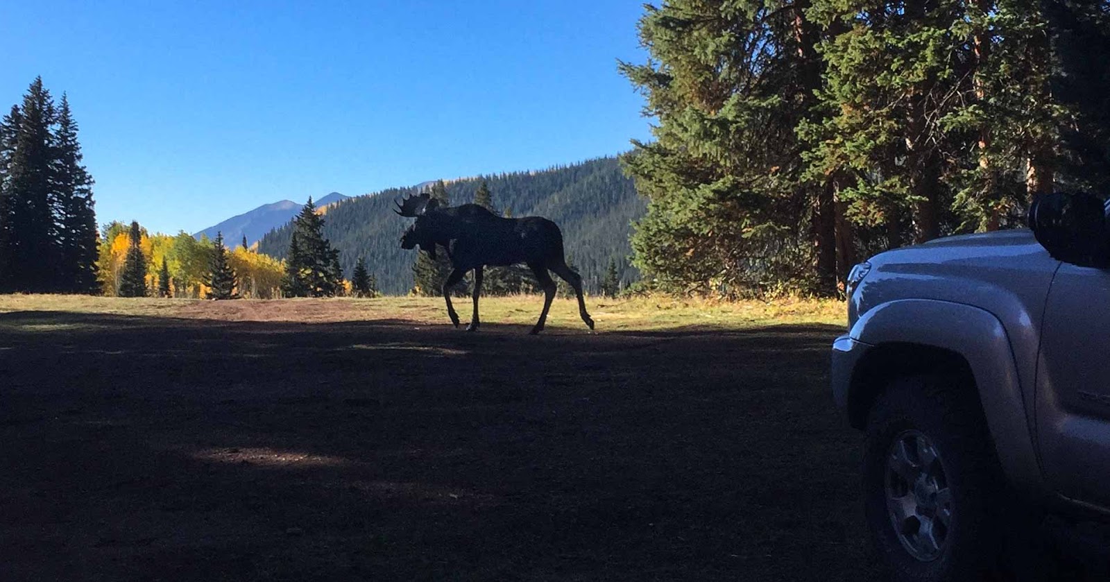
Sept. 21: Just after breakfast, Felice went to get something out of the truck. Something was coming out of the trees, just a few feet away from the trailer -- a fairly large bull moose! She called to me and (showing great presence of mind) snapped a couple of photos with her iPhone:

After the excitement of the moose wore off, we finished our coffee:

This is not a trick shot -- that is a reflection in the window:

We headed back into town to do a few errands but were waylaid by Gothic Mountain:

That afternoon, we had time for a short hike in the upper part of Washington Gulch. The trailhead was at around 11,000 feet; we hiked for about four miles (round trip). The road up to the trailhead was not too rough, but there was one hairpin curve that was too tight for a long wheelbase truck, so we had to do a three-point turn. That was something I had never encountered.
From the trail, we could see into the Slate River canyon, otherwise known as the "Oh-Be-Joyful" area (great name!):

The trail leading from Washington Gulch over to the Gothic Valley looked down on the town of Crested Butte:

The geology of the Gothic Valley was complex -- the strata ran every which way:

Sept. 22: We headed out toward Kebler Pass on Route 12, a surprisingly-busy gravel road, to Horse Ranch Park, and took the Gold Creek trail. We hiked around 7 miles, round trip, with less than a thousand feet of elevation gain.
Not far from the trailhead, we came across an aspen grove under attack by some ambitious beavers. At first, we could not figure out why they would cut down so many large aspens and then just abandon the trunks, wasting all of that effort:

But a close look at a nearby pond cleared up the mystery -- they cut down the trees so that they could get to the branches to build their lodges and their dams. Note that the leaves on these branches are still fresh and green -- very recently cut!

All along the trail, there were good views through the trees -- this is East Beckwith Mountain, I think:

According to our guidebooks, the aspen groves in this area are some of the largest in North America:

The trail passed through the Raggeds Wilderness (not ragged):

I am pretty sure that the arched peak is Marcellina Mountain, on the left side of this photo. Geology aficionados (and aren't we all?) will of course recognize it as a classic laccolith, where a blob of magma rose under the base of the mountain, caused the overlying strata to bow:

(Just to be clear, I did not know that until I looked it up.)
The aspens were so bright and so dense that the air looked like light green water. We took a super slo-mo movie:
On our way back to our campsite, we came across my favorite road sign:

Back in town, we noticed a lot of activity. It turns out that this was the local celebration of Vinotok, a pagan harvest holiday, complete with a bonfire and a parade. Felice got so excited that the end of the video has the marchers going straight up:
It was too chilly to have cocktail time outside, but we could still see the late afternoon sun on the aspens:

That evening, we discovered that in addition to the promised "20 friends," a new group arrived, about 50 kids from town, with little tents dotted all around us. Not too close, but still annoying. They all went down to town to participate in the Vinotok festivities and then came back late at night. Fortunately, they were not too noisy, and they were all gone by the middle of the next morning. Most astonishingly, they did not leave one speck of trash -- a miracle!
We headed up through the Gothic area to the trailhead (just north of Schofield Pass). The guidebook warned us that the access road from Schofield Pass to the North Pole trailhead would be tricky, and it was -- very narrow, very rough, cut into the side of a significant cliff. Much more suitable for a little Jeep than a full-size truck.
We crawled along very slowly and carefully. Big bulging ridges of bedrock caused the truck to lean over sideways toward the edge of the cliff. I was not alarmed, but I was fully alert (and having fun, in a cautious way). At one particularly challenging place, Felice threatened to jump out and walk. (She didn't, at least not this time.) I asked her to take a video of the truck inching over the really interesting boulders, but she did not think that this would be a good idea.
Fortunately, when we got to the trailhead, there was a small flat space available for parking. We were the only vehicle at the trailhead (always a good sign!), although later in the day two more vehicles arrived. (Most of the trail is on land belonging to the Rocky Mountain Biological Laboratory.)
The first part of the trail was pleasant but unremarkable, winding upward through the forest. At one point, we came across an abandoned wooden hot tub, so I climbed in:

(It turns out that this hot tub belonged to a defunct resort, which is now part of the RMBL property.)
Eventually, the trail breaks out of the trees and begins a fairly steep climb up an old mining road. As we climbed, the south side of the Maroon Bells came into view:

The upper portion of the trail was above treeline, with sweeping views of the surrounding peaks:

This shot provides an even better view of the Maroon Bells, in the center of the photo. For most of the day, we were completely alone in this chilly and breezy basin, at nearly 13,000 feet:

Felice is looking up at the uptilted strata of Crystal Peak:

Sept. 24: After breakfast, it looked like it was going to rain; being hardy Californians, we just hitched up and fled, heading down to Montrose for some errands, and then on to Silverton. As we left Washington Gulch, we stopped for one last view of Gothic Peak:

Next: Part 4 (Silverton)
1 comment:
Moose, beavers, fifty tents, beautiful fall color, wonderful hikes, pagan holidays; what an adventure! Thanks for letting us come along!
Post a Comment